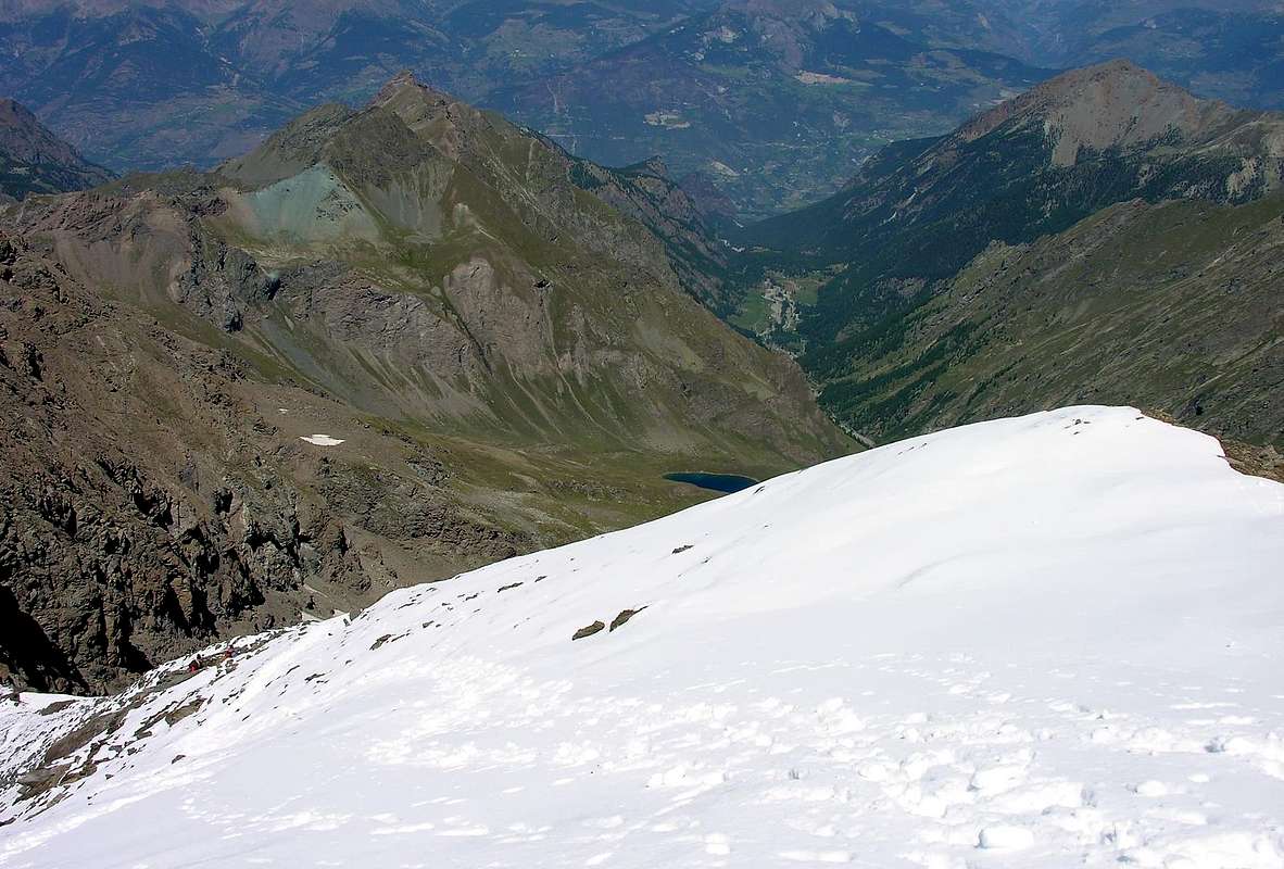
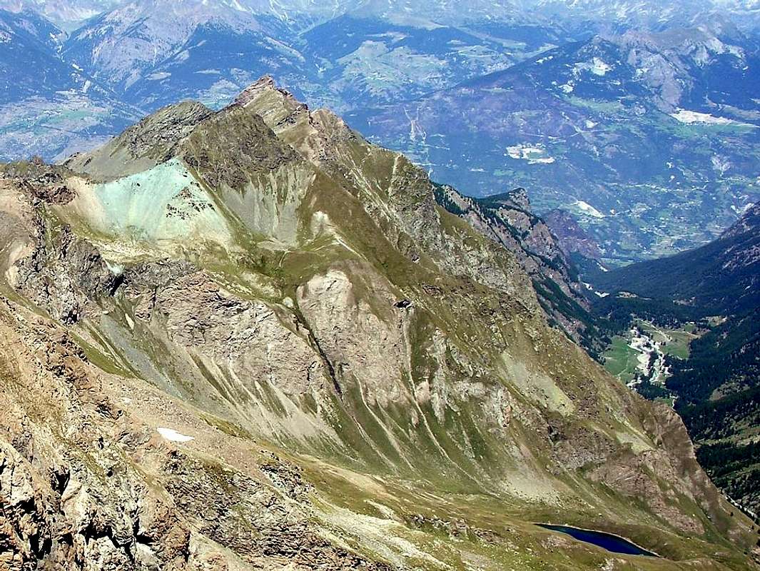
Small pyramid on the watershed between the Saint Marcel and Fénis-Clavalité Valleys. Summit sparsely attended due to the long approach both from Fénis (Barche) and from Saint Marcel (Druges Alta). Very good panorama on Punta Garin, Monte Emilius and Grande Roise to NW and on Mont Avic, Mont Rafray, Mont Glacier and Mont Delà to the East.
Piccola piramide sita sulla cresta spartiacque tra i Valloni di Saint Marcel e Fénis-Clavalité. Montagna non molto frequentata per le lunghe marce di avvicinamento sia da Fénis (Barche), che da Saint Marcel (Druges Alta). Ottimo panorama sulla Punta Garin, Monte Emilius e Grande Roise a Nord-Ovest e su Mont Avic, Mont Rafray, Mont Glacier e Mont Delà ad Est.
First Ascents
First on the summit: unknown.
In winter: unknown.
SW Crest and Edge (Standard Route): Unknown, in ascent from Terre Bleue Pass.
E Face and SW Crest in final part: , Osvaldo Cardellina and Giuseppe Lamazzi (Aug 11th, 1996), in ascent from Les Druges Alte, Mulàc, Petite Chaux Alp and through Terre Bleue Pass; in descent SW Ridge integral to Col 2.823 meters or Terre Bleue .
W Face (Western or of Right Edge): Osvaldo Cardellina, lone (May 04th, 2008), in ascent from Les Druges Alte, Servette, Eteley, Mulàc, Plan Rué, Emonin, Layet Alp and Loch, Petite Chaux High Pastures and subsequent crossing towards Grand Avert Hill, Grande Cresta (South Crest), Punta Plan Rué (Southern Ridge), Mont Corquet up to the Mont Roux and descent to Corquet, Prapremier, Bren, Fontainefroide Pastures and Les Druges Alte Hamlet.
W Face (Left or Northern Side): Osvaldo Cardellina, lone (Jun 29th, 2008), in ascent from Vargney/Pouria/Roquilllod, Servette, Mulàc, Plan Rué, Emonin, Layet reaching Petite Chaux last Alp and same route to Servette, Pouria, Les Druges Tall.
N-NE Ridge: unknown, in ascent from Grand Avert Pass.
N-NE Wall: Osvaldo Cardellina, solo (Jul 01th, 1995) , in ascent from Barche, Lovignana, Margheron, Robbio, Maisonnasse, Celey, fork1862 meters into the Val Fénis to Bayet and Arcolo Pastures below Grand Avert Pass; in descent SW Crest integrally to Lavòdiléc Hill, Lake, Alp to Meney Damon Pasture.
Getting There
BY CAR:
From Torino, Milano, etc: Motorway A5. Exit Aosta est For Grand Brissogne and Saint Marcel.
From Switzerland: through the Grand St. Bernard Tunnel or the homonym Pass. Drive to Aosta, For Grand Brissogne and Saint Marcel.
From France: through Mont Blanc Tunnel or Petit St. Bernard Pass. It isn't necessary to enter in Motorway A5, you can drive through SS.26 Aosta direction. Exit Aosta est For Grand Brissogne and Saint Marcel.
BY PLANE:
Aeroporto "Corrado Gex" Saint Christophe (Aosta).
Topography
As mentioned in the Overview, this mountain is located in the partition between the Valleys of Saint Marcel (West) and Fènis-Clavalité-High Comba Tersiva. More precisely, the long watershed that got out of Punta Tersiva (3.515m), divides at Punta del Tessonet (3.264m); this branch goes more to the Northwest, and after Gianni Vert and Laval Summits, reaches the Saint Marcel Hill or Corona (2.916m). In addition, this branching is split further by forming the Chain of Roises and the Group of Mount Emilius (3.559m), both on the Central Valley of Dora Baltea. A second branch proceeds from Tessonet decidedly toward the North, and after Lavodilec Hill (2.870m) gets up in the two Avert, Petit (2.946m) and the Grand (2.991m); themselves are divided by an unnamed hill on the Maps, but known by local visitors, due to the bluish color of the rocks and soil that cover it, as Col de Terre Bleue (2.820/3m). After the Grand Avert the crest form of the same name Col (2.832m), immediately followed by a crest that advances more and more jagged ridge called the Gran or Great-Crete and someone known as "Crest of the Devil" (2.908m; there an Inn with such a name just before Les Druges at the entrance of the Valley of St. Marcel); this stands up with some pinnacles and three jumps to the next Tip Rué Plan (2.877m). Two other collars, the first of which is told by the Hunters of deer "Belfrond Collar" (2.598m), anticipate Crotey Col (2.460m), net and deep carving before long, flat grassy ridge that reaches Mount Corquet (+ 2.530m). A final subdivision sends a short ridge to Mont Roux (2.280m) with the its Coppermines of Servette-Chuc, while on the opposite side of the partition with the Municipality Fénis leads to the Torasse or Mont-Touriasse (1.903m) end with the rocky-wooded promontory Mont Saint-Julien (1.377m), which houses the Shrine of St. Grat and includes "perched" on a high wall, which falls above the Vallon of the Clavalité the renowned Hermitage of the same name.
Come già detto in Overview, questa montagna é collocata nel divisorio tra i Valloni di Saint Marcel (Ovest) e di Fénis-Clavalité-Alta Comba Tersiva. Più precisamente sul lungo spartiacque che, scendendo dalla Punta Tersiva (3.515 m), si divide alla Punta del Tessonet (3.264 m); da questa un ramo procede maggiormente a Nordovest e, dopo le Punte Gianni Vert e di Laval, raggiunge il Colle di Saint Marcel o Corona (2.916 m). Oltre, questa ramificazione si sdoppia ulteriormente formando la Catena delle Roises ed il Gruppo del Monte Emilius (3.559 m), entrambi sulla Valle Centrale della Dora Baltea. Una seconda ramificazione procede dal Tessonet decisamente verso Settentrione e, dopo il Colle di Lavodilec (2.870 m) si rialza nei due Avert, il Petit (2.946 m) ed il Grand (2.991 m); gli stessi sono separati da un colle innominato sulle Carte, ma conosciuto da parte dei frequentatori locali, causa il colore bluastro delle rocce e del terriccio che lo ricoprono, come Col di Terre Bleue (2.820/3 m). Dopo il Grand Avert, la cresta spartiacque forma l'omonimo Colle (2.832 m), subito seguito da una cresta che avanza sempre più frastagliata chiamata la Gran Cresta o Grande-Crete e da qualcuno conosciuta come "Cresta del Diavolo" (2.908 m; esiste una Locanda con siffatto nome appena prima di Les Druges, all'ingresso del Vallone di St. Marcel); questa si alza con alcuni pinnacoli e tre salti verso la successiva Punta di Plan Rué (2.877 m). Altri due colletti, il primo dei quali é detto dai Cacciatori di camosci "Colletto Belfrond" (2.598 m), anticipano il Col Crotey (2.460 m), netto e profondo intaglio prima della lunga e piatta dorsale erbosa raggiungente il Mont Corquet (+ 2.530 m). Un'ultima suddivisione invia una breve cresta al Mont Roux (2.280 m) con le sue Miniere di rame di Chuc-Servette, mentre sul lato opposto il divisorio con il Comune di Fénis conduce a La Torasse o Mont-Touriasse (1.903 m) per terminare con il promontorio roccioso-boschivo di Mont Saint Julien (1.377 m), che ospita il Santuario di San Grato ed include "abbarbicato" su di un'alta parete, precipitante sopra il Vallone della Clavalité, il famoso nonché omonimo Eremitaggio.
Route
From Les Druges Alta – Pouria (1.600m), along the dirt road to the Petite Chaux Pasture (2.419m). From the pasture, along the path joining the valleys, to the minor summit 2.658. Herefrom, along tracks toward East up to the Colle di Terre Bleue (2.820/3m). Now to NE up to the Quota (2.940m), where the ridge becomes more narrow, almost an edge. Along stacked boulder up to a detached "small cannon" wherefrom the edge gets much steeper Climbing a short wall and a grassy dihedral (II°, quite exposed to SE, dangerous if wet) you get the last ridge that, with an easy scramble, leads to the summital Cross (3h'45).
Da Les Druges Alta – Pouria (1.600 m), raggiungere per strada poderale l'Alpeggio Petite Chaux (2.419 m). Dall'alpe per il sentiero intervallivo raggiungere la Quota 2.658 m Da questo punto seguire la traccia di sentiero verso Est fino al Colle di Terre Bleue (2.820 m); dirigersi ora verso Nord Est fino a Quota (2.940 m), ove la cresta diventa spigolo. Risalire per blocchi accatastati ad un "cannoncino" distaccato, oltre il quale lo spigolo si impenna; per una breve paretina ed un diedro con erba (II°, molto esposto a Sud-Est; infido se bagnato) si tocca il crinale della vetta, che per blocchi conduce alla croce (3h'45).
Difficulty
This route can be considered EE/A, F+.
L'itinerario è classificato EE/A, F+.
Gear
Standard mountaineering equipment.
Campings
Remember that free camping is forbidden (except for emergency reasons, over 2.500m, from darkness until dawn).
Mountain Conditions
You can get meteo information at the official site of the Regione Valle d'Aosta:
"Guida delle Alpi Occidentali" di Giovanni Bobba e Luigi Vaccarone C.A.I. Sezione di Torino Volume II (parte II), 25 Maggio 1896.
"Guida dei Monti d'Italia – Emilius Rosa dei Banchi-Parco del Mont Avic" di Giulio Berutto e Lino Fornelli - Club Alpino Italiano/Touring Club Italiano, Marzo 2005.
"Guida della Regione Autonoma Valle d'Aosta" di Mario Aldrovandi; Ed. S.P.E. di Carlo Fanton, Torino 1964.
"Diari Alpinistici" di Osvaldo Cardellina e Indice Generale accompagnato da Schedario Relazioni Ascensioni 1964-2019 (inediti).
MAPS:
Kompass "Gran Paradiso Valle d'Aosta Sentieri e Rifugi" Carta Turistica 1:50.000.
L'Escursionista "Parco Naturale del Mont Avic" Carta dei sentieri 1:25.000.
L'Escursionista "Tour de la Vallée de Cogne Grand Paradis" Carta dei sentieri 1:25.000.
Hapax "Les Sentiers" Comunità Montana Monte Emilius, Luglio 2000 1:25.000.
Meridiani Montagne "Gran Paradiso" 1:25.000.
I.G.C. Istituto Geografico Centrale Torino "Il Parco Nazionale del Gran Paradiso" 1:50.000.
Studio F.M.B. "Gran Paradiso" Bologna 1:50.000.
Enrico Editore Ivrea-Aosta "Gruppo del Gran Paradiso" 1:50.000.
L'Escursionista "Valle di Cogne" Carta dei sentieri (n° 10) 1:25.000.
FONDAZIONE MONTAGNA SICURA Villa Cameron, località Villard de la Palud n° 1 Courmayeur (AO) Tel: 39 0165 897602 - Fax: 39 0165 897647.
A.I.NE.VA. (Associazione Interregionale Neve e Valanghe).
Useful numbers
Protezione Civile Valdostana località Aeroporto n° 7/A Saint Christophe (Ao) Tel. 0165-238222.
Bollettino Meteo (weather info) Tel. 0165-44113.
Unità Operativa di Soccorso Sanitario Tel. 118.
Acknowledgements
I am greatly indebted to my friend "Osva" for the detailed description of the route and to "Topography". In addition i want to thank Gabriele Roth for the translation of the text from italian.
Parents refers to a larger category under which an object falls. For example, theAconcagua mountain page has the 'Aconcagua Group' and the 'Seven Summits' asparents and is a parent itself to many routes, photos, and Trip Reports.

 8901 Hits
 82.48% Score
 15 Votes