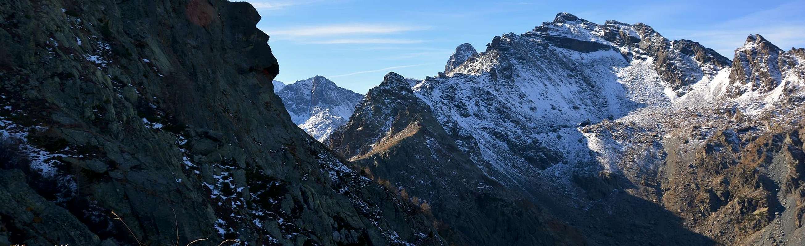
Great mountain immediately to the East of Mount Iverta divides the Walloon of the Lago Gelato from the most to the East of the Lakes, in fact descends from the top to the North-northeast a large rocky ridge, formed Testa Piana (Flat Head; 2.607m) and the subsequent quota 2.503 meters, ending with the small, but very bold, the pyramid of Bec Espic (2.536m), on the walls of which were drawn many routes, demanding rock. Even over long Ridges West-Northwest, North-northeast and East-northeast, as well as those of the two previous units have been opened since the 2000 of interesting climbing routes, by local climbers. This mountain is also called L'I(E)nvers del Lago Gelato, which in the local dialect means mountain located behind (logically the lake) and in the less exposed to the sun or "Adret", has four ridges that surround many fronts. To the West is the Valley of Lago Gelato with its ancient ironmines, while North down the Walloon of the Torrent de Chalamy which originates from Lago Gelato same, as well as by its Northern Side, the other two walloons have turned to the Northeast on a wild valley between a spur of the ridge towards the secondary and the Espic Bec and east over the Great Gorge. The last one, to the south, less steep falls over the Plateau dell'Iverta, locked between Mont Iverta little Medzove Point and Mont Belplà. Mountain whose ascent does not present any kind of difficulties but less popular and and even less frequented, because the length of the approaches. Accessible, in fact, also from Barbustel Refuge (2.200 meters) just below the Lago Bianco Hill (2.309m) on the watershed dividing the Champorcher Valley, and from this a long crossing to Northwest leads to Plateau of the Iverta, reconnecting the ascent route described below. Beautiful views over the nearby Group of Mont Avic Northwest and on the Mont Glacier to the South.
Grande montagna subito ad Oriente del Monte Iverta, divide il Vallone del Lago Gelato da quello più ad Est dei Laghi; dalla sua sommità infatti scende verso Nord-nordest un grande crestone roccioso che, formata la Testa Piana (2.607 m) e la successiva Quota 2.503 metri, termina con la piccola, ma alquanto ardita, piramide del Bec l'Espic (2.536 m), sulle pareti del quale sono state tracciate numerose vie, impegnative, in roccia. Anche sulle lunghe Creste Ovest-Nordovest, Nord-nordest ed Est-nordest, nonché su quelle delle due precedenti quote, sono state aperte dall'inizio degli Anni 2000 delle interessanti vie di arrampicata, da parte di alpinisti locali. Questa montagna chiamata anche L'I(E)nvers del Lago Gelato, che in dialetto locale significa montagna posta dietro (logicamente al lago) e nella zona meno esposta al sole ovvero "Adret", presenta quattro creste che delimitano altrettanti versanti. Ad Ovest rimane il Vallone del Lago Gelato con le sue antiche miniere di ferro, mentre a Nord scende il Vallone del Torrent de Chalamy che prende origine dal Lago Gelato medesimo, nonché dal suo Versante Settentrionale; altri due valloni sono rivolti a Nordest su di una selvaggia gorgia tra un contrafforte secondario e la cresta verso il Bec l'Espic ed a Est sopra la Gran Gola. L'ultimo, verso Sud, scende meno ripido sopra il Plateau dell'Iverta, rinchiuso tra il Monte Iverta, la Piccola Punta di Medzove ed il Mont Belplà. Montagna la cui salita non presenta nessun tipo di difficoltà ma poco conosciuta ed ancor meno frequentata, causa la lunghezza degli avvicinamenti. Raggiungibile, infatti, anche dal Rifugio Barbustel (2.200 m~) appena al di sotto del Colle del Lago Bianco (2.309 m) sulla cresta spartiacque con la Valle di Champorcher; da questo una lunga traversata verso Nordovest conduce al Plateau dell'Iverta, ricollegandosi alla via di salita qui sotto descritta. Belle le vedute sul vicino Gruppo del Monte Avic a Nordovest e su quello del Mont Glacier verso Mezzogiorno.
First Ascents
First on the summit: Unknown.
In winter: Unknown.
W-NW Edge and Great Crest: Erik Bellotto, Diego Gaioni and Franca Stevenin, (Jun 24th, 2000), in ascent.
N-NE Ridge Diego Margiotta, (Aug 23th, 2001).
E-NE Ridge: Felice Bechon and Diego Margiotta, (Oct 12th, 2001).
E Crest of Quota 2.503 meters: Diego Margiotta and Felice Bechon, (Jul 11th, 2000).
E Crest of Quota 2.503 meters (Variant): Diego Margiotta and Marco Giampietri, (May 29th, 2002).
Quota 2.607 meters on E-NE Ridge: Diego Margiotta, Piero Palma and Mauro Ratti, (Jul 29th, 2001).
Same Wall, "Via Ricerca Laterale": Diego Margiotta and Andrea Giulivi, (Aug 12th, 2001).
Same, "Via Il camino degli Elfi": Diego Margiotta and Gian Paolo Chiola, (Jun 29th, 2002).
Quota about 2.625 meters, "Via Torre Rossa": Diego Margiotta and Felice Bechon (Jun 16th, 2001).
"Via Torre Staccata": Diego Margiotta, lone, (Aug 23th, 2001.
SE Spur: Diego Margiotta and Teresio Macagno, (Sep 28th, 2002).
Getting There
BY CAR:
From Torino, Milano, etc: Motorway A5. Exit Verrès for then to continue on SS.26 toward Champdepraz.
From Switzerland: through the Grand Saint Bernard Tunnel or the namesake pass. Drive to Aosta, Verrès and Champdepraz.
From France: through Mont Blanc Tunnel or Petit Saint Bernard Pass. It isn't necessary to take Motorway A5: you can drive on SS.26, in the direction of Aosta and Verrès.
BY PLANE:
Aeroporto "Corrado Gex" Saint Christophe (Aosta).
Road Itinerary
From the Municipalities of Verrès (391m) in Southeast, or Montjovet (489m) to catch up with the Northwest Regional Road, South of Dora Baltea and Motorway A5, to Champdepraz (523m), located at the entrance of the with the same name valley. From this go along way toward Southeast with a first series of seven switchbacks to the junction, near the Bridge of Gorf, for Gettaz des Allemands (995m, old village that bears witness to the passage of Walser) a dozen others, even closer, door in the upper part of the walloon, dominating from steep and wild precipices overhanging the Torrent de Chalamy, which originates at the base of the Northern Slope of the Invers. Left to right (West) to the branch Crestaz (1.293m) with its ancient ironmines, the same goes with a long diagonal to the South reaching Villages Barbustel or Barbuste (1.240m) and the adjacent Covarey, just before you reach Volla or Voella (1.307m; Museum of the Natural Park of Mont Avic, small restaurant with a few rooms amongst the houses not long ago renovated keeping the style of the Aosta Valley), where it ends with ample parking.
Dai Comuni di Verrès (391 m) a Sudest, oppure Montjovet (489 m) a Nordovest raggiungere con la Strada Regionale, a Sud della Dora Baltea e dell'Autostrada A5, quello di Champdepraz (523 m), sito all'ingresso dell'omonimo vallone. Da questo percorrer la strada verso Sudest con una prima serie di sette tornanti insino al bivio, presso il Ponte di Gorf, per Gettaz des Allemands (995 m, vecchio villaggio testimoniante il passaggio dei Walser); una dozzina d'altri, ancor più ristretti, porta nella parte alta del vallone, dominando dall'alto erti e selvaggi dirupi sovrastanti il Torrent de Chalamy, che si origina proprio alla base del Versante Settentrionale dell'Invers. Lasciata a destra (Ovest) la diramazione per Crestaz (1.293 m) con le sue antiche miniere di ferro, la stessa procede con un lungo diagonale verso Sud raggiungendo i Villaggi di Barbustel o Barbuste (1.240 m) e l'attiguo di Covarey, appena prima di raggiungere Volla o Voella (1.307 m; Museo del Parco Naturale del Monte Avic, piccolo ristorante, con alcune camere, tra le case da non molto tempo ristrutturate mantenendo lo stile valdostano), dove termina con ampio parcheggio.
Approaches
Approach A (From Voella little Hamlet in Champdepraz Valley) From the Hamlet of La Ville-Veulla through the farm road to the "Magazine" until the junction for Pra Oursì Pasture, at an altitude of 1.340 meters; go in the direction of West passing a first torrent and a second reaching the pasture at an altitude of 1.791 meters(1h'15). From Pra Oursì Pasture definitely changing direction towards the South to reach the path that leads through, first the path that leads from the "Warehouse" and then into the gorge central halls Volla or Walloon of Chalamy. From this junction continue through the path n° 6 which dates from the same passing parallel and just above the Chalamy Torrent. The same goes wedged deeper into the small valley and, through long straight section under a rock band at the base of the South East Slope of Mount Avic, shall be directed towards a narrow passage formed by the three rock outcrops that descend from Envers of Lake Ice (2.915m), the second highest mountain in altitude for the small subgroup. In foreground stands the gloomy ominous spire of the Bec l'Espic, overlooking the valley with his daring Walls, always continuing along the left side basin (West), the path turns away from the Torrent Chalamy to go round to the right (West always) a rocky spur and "broken" and would be the first or most Northern of those who go down almost parallel by mass dell'Invers. The trail gradually turns into a dirt road, built for the descent of the mineral through large sledges, reaching a more open below the glacis which are located above the loadstone mines. Turning more to Southeast the same, supported by dry stone walls and embankments, through discharges of the same; turning then reaches a plateau in the Southwest near the emissary of Lake Gelato. As they came near the caves of Mines (closed), leaving just the top right corner the remains of barracks and a refuge of Forestry (private and closed) reaches the narrow ledge Northern of the lake (3h'45/4h'00).
Avvicinamento A (Dal Villaggetto di Voella nel Vallone di Champdepraz) Dalla Frazione di La Ville-Veulla, per la strada poderale verso il "Magazzino" sino al bivio per Pra Oursì a quota 1.340 m; salire con direzione Ovest superando un primo torrentello ed un secondo raggiungendo l'alpeggio a quota 1.791 m(1h'15). Da Pra Oursì, cambiando decisamente direzione verso Sud, raggiungere, tramite il sentiero di collegamento, dapprima il sentiero che sale dal "Magazzino" e successivamente inoltrarsi nel vallone centrale che sale da Volla o Vallone di Chalamy. Da questo bivio proseguire per mezzo del sentiero n° 6 che risale il medesimo transitando parallelamente ed appena più in alto dell'omonimo torrente. Lo stesso prosegue incuneandosi sempre di più nel valloncello e, passando per lungo tratto rettilineo sotto una fascia rocciosa che cinge alla base il Versante Sudest del Monte Avic, si indirizza verso una strettoia-giogaia formata da questo e da tre costole rocciose discendenti dall'Invers del Lago Gelato (2.915 m), seconda vetta in altitudine per il piccolo sottogruppo. Frontalmente s'erge minacciosa la scura guglia del Bec l'Espic, dominante dall'alto il vallone con le sue ardite pareti; sempre proseguendo lungo il versante sinistro idrografico (Ovest), il sentiero s'allontana dal Torrente Chalamy per andare a doppiare sulla destra (sempre Ovest) una costola rocciosa e "spezzata" tale da costituire la prima o più Settentrionale di quelle discendenti quasi in parallelo dalla massa dell'Invers. Il sentiero progressivamente si tramuta in una carraia, costruita per la discesa del minerale tramite slittoni, raggiungendo una parte più aperta sottostante lo spalto sopra al quale son site le miniere di magnetite. Volgendo più a Sudest la medesima, sostenuta da mura a secco e massicciate, attraversa gli scarichi delle medesime; volgendo poi a Sudovest raggiunge un altipiano nei pressi dell'emissario del Lago Gelato. Passando presso le caverne delle miniere (chiuse) e lasciando appena in alto a destra i resti dei baraccamenti ed un Rifugio della Forestale (privato e chiuso) raggiunge la stretta sponda Settentrionale del lago (3h'45/4h'00).
Approach B (From the Royal dirt Road by Dondena, Lake Bianco Hill to Barbustel Shelter) From the little Village of La Cort, to continue verse West-northwest on the Real dirt Road to Dondena Village reaching not very after a small parking lot near and along the same one (1.830/40m about; noumerous signs and entry in the Park of the Avic Mountain); to begin awry immediately with the path n° 10 that part (North) and it goes up again with a steep zigzag bringing itself, with direction Northeast, at first toward a small secondary torrent and subsequently placing side by side that more important descendant from the impending Lake Muffé. To go up again along the bank right hydrographic of the same one with the path, almost mule-track, that unties him with a series of hairpin bends flanking the wood, alternate to rectilinear lines in diagonal. To go out, leaving on the right (East) the deviation for the La Grand Cort Pasture (1.944m, that from he is quietly seen here, abandoned among green pastures) so in the superior tableland in her narrowing among the appendixes of the Mount Ros (2.289m) to West and you it terminal of the Southwestern Crest that it climbs to the Point Perche (2.396m; also with the toponym of Perché, or Perforated), or Southern shoulder of the Cima Piana (Plain Top also called Mont de Panaz 2.512m). Continue on the walloon floor through less steep slope with run mostly "open" and, abandoning on the left (West) the deviations for the Loch Vernouille (2.145m) with the paths n° 9C/10B and, momentarily, also the n° 10, to climb with the n° 10C reaching the ruin of the old Muffé Pasture (2.076m), close to the homonym Lake suffered to East I approach (2.119m; 0h'30). From this to ascend up with direction Northwest in a area even more disclosed among small backs with lawns and moraines (small sources that gush out a little everywhere) again meeting the path "of base" n° 10, that it originates from the Lake Vernouille, few more than hundred meters more aloft. To abandon therefore the aforesaid variation continues with, that continues in opposite (Northeast) toward the nearby Loch Bianco Hill (2.308m), and to proceed with this last I pour the neighbour Col de la Croix (2.287m), reaching it with a final line of a more steep. A short descent leads quickly to the Barbustel Shelter, at Lake Bianco in the Upper Walloon of Champdepraz also Lochs Walloon (E; 1h'15/1h'45).
Avvicinamento B (Dalla Strada Reale per Dondena, Colle del Lago Bianco verso il Rifugio Barbustel) Dal Villaggetto di La Cort, continuare verso Ovest-nordovest sulla sterrata Strada Reale Dondena raggiungendo non molto dopo un piccolo parcheggio presso e lungo la medesima (1.840/50 m~; nunerose segnalazioni ed ingresso nel Parco del Monte Avic); iniziare con il sentiero n° 10 che prende inizio subito a monte (Nord) e risale con un ripido zig-zag portandosi, con direzione Nordest, dapprima verso un torrentello secondario e successivamente affiancando il più importante, discendente dal soprastante Lac Muffé. Risalire lungo la sponda idrografica destra del medesimo con il sentiero, quasi mulattiera, che si snoda con una serie di tornanti affiancando il bosco, alternati a tratti rettilinei in diagonale. Uscire, lasciando sulla destra (Est) la deviazione per l'Alpe La Grand Cort (1.944 m, adagiata tra verdi pascoli) così nell'altipiano superiore nella strettoia tra le appendici del Mont Ros (2.289 m) ad Occidente e la propaggini terminali della Cresta Sudovest risalente alla Cima Perche (2.396 m; o Perché, cioé Forata), o spalla Meridionale della Cima Piana o Mont de Panaz (2.512 m). Continnuare sul fondo del vallone con percorso alquanto meno ripido e maggiormente "aperto" e, abbandonando sulla sinistra (Ovest) le deviazioni per il Lac Vernouille (2.145 m) con i sentieri n° 9C/10B nonché, momentaneamente, anche il n° 10, risalire tramite il n° 10C raggiungendo i ruderi dell'Alpe Muffé (2.076 m), vicino all'omonimo Lago, subito ad Est appresso (2.119 m; 0h'30). Da questo proseguire con direzione Nordovest in una zona ancora più dischiusa tra piccoli dossi con prati e morene (piccole sorgenti che sgorgano un poco dovunque) incontrando nuovamente il sentiero n° 10, proveniente dal Lac Vernouille, poco più di un centinaio di metri più in alto. Abbandonare quindi la variante seguita, che continua in opposta direzione (Nordest) verso il Col de la Croix (2.387 m), e continuare con quest'ultimo verso il Colle del Lago Bianco (2.308 m), raggiungendolo con un tratto finale di poco più ripido. Una corta discesa conduce in breve tempo al Rifugio Barbustel, presso il Lago Bianco nell'Alto Vallone di Champdepraz conosciuto anche come Vallone dei Laghi (E; 1h'15/1h'45).
Routes
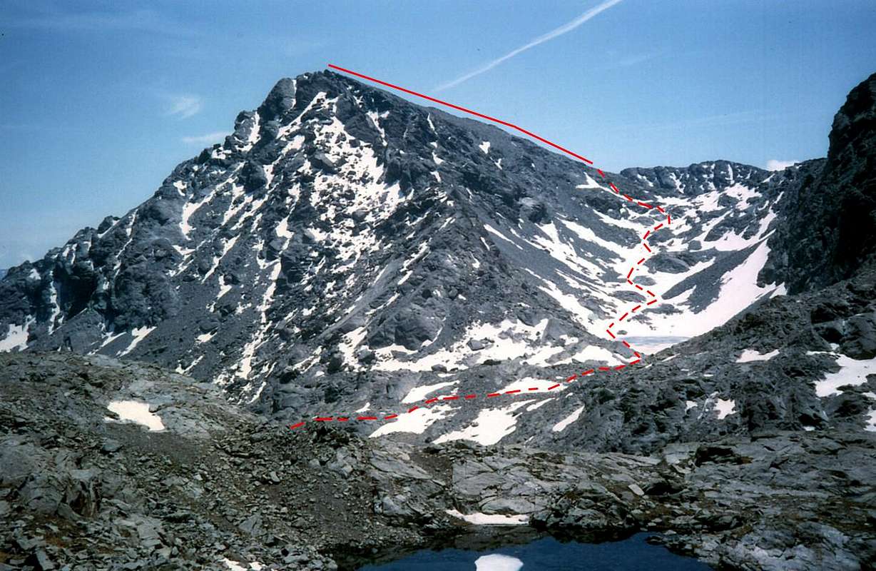
Route A (From Voella Hamlet through Frozen Loch Via) From Lago Gelato, leaving behind the entrance of the mines and the remains of the huts of the miners, continue with the path n° 6 and heading South-southeast along the North shore of the lake and then below the West-northwest Ridge of Envers, bending slightly to the right so you can reach the same Collar of Invers at an altitude of 2.720 meters and immediately below the Iverta Plateau, where there are the small Lacs des Heures (2.750m). Leaving them on the right (Southeast), go in the opposite direction along the Southwest Crest, composed of debris and small rocks falling apart, easily reaching the Summit (1h'15/1h'30; in total 5h'00/5h'30 from Veulla Village).
Via A (Dal Villaggio di Voella per la Via del Lago Gelato) Dal Lago Gelato, lasciando alle spalle l'imbocco delle miniere nonché i resti delle baracche dei minatori, proseguire sempre con il sentiero n° 6 e con direzione Sud-sudest lungo la sponda Settentrionale del lago e, successivamente, al di sotto della Cresta Ovest-nordovest dell'Envers; piegando leggermente più a destra si raggiunge così il Colletto dell'Invers medesimo a quota 2.720 metri circa e subito appresso il Plateau dell'Iverta, ove son situati i piccoli Lacs des Heures (2.750 metri circa). Lasciandoli sulla destra (Sudest), salire in senso opposto lungo la Cresta Sudovest, composta da detriti e piccole rocce in sfacelo, raggiungendo facilmente la Sommità (1h'15/1h'30; in totale 5h'00/5h'30 dal Villaggio di Veulla).
Route B (From Champorcher Valley by Barbustel Shelter) With the same way at the end, but reaching the Plateau of Iverta and the Collar of Envers starting from Champorcher Valley and using the Barbustel Refuge (2.209m), at the Lake Bianco. Excursion has become more popular with the construction of the same, the utility for the climbs of all satellites Mount Glacier but also for the crossing to the L'Envers and the nearby Mount Iverta. Through the Approach B reach the refuge (1h'20/1h'30 from the car park of the Royal Road Dondena). From this go up into Walloon of the Lakes on the Upper Valley Champdepraz and, with the trail n° 6/102, passing in succession the Lake Bianco (2.154m) via a short descent, Nero (2.166m) and Cornuto (2.168m), passing just above their banks and reaching to the North Pisonet Alpage (2.301m), located at the end of this first part of the walloon below and a rocky promontory. From this path, which gradually turns into beautiful muletrack, turned decidedly from the West to the South and the steep back with a dozen hairpin bends standing at Grand Lake (2.485m; 1h'45/2h'00), the largest in Aosta Valley and at the beginning of the second and upper part of the vallon. Flanking its Northern shore is reached at a small waterfall, and its tributary immediately below the Bivouac Verthuy of the Forest (2.535m; private and closed), amid a swarm of small lakes called of Leità. Here the trail splits by sending a branch to the Southwest and the Medzove Pass (2.613/4m), which leads into the Walloon of Savoney, secondary to the Fénis-Clavalité, left abandoned this, instead it continues to the North-northwest, always with the path n° 6 which, becoming less pronounced among grassy fields, reach the limited Plan of the Betassa. Through this narrow basin to reach the base of a small, steep grassy gully that goes back to the small saddle around 2.800 meters immediately to the West of Mount Belplà also Bel Plat (2.828/9m) up the short path and traces encountering yellow signs, not always evident, and some stone mound. From the saddle to climb the nearby watershed ridge and continue under the same heading North past the little Point of Medzove (2.848m) just to the right, with a scenic route, but that requires attention in the presence of snow or ice. Reached the small lake 2.762 meters, the small trail descends in Southeast completely changing direction and reaching the Plateau of the Iverta, the Lakes of Heures and subsequent Envers Collar, whence the Via A (1h'20/1h'30; total in 3h'15/3h'30; 4h'00 at Summit).
Via B (Dalla Valle di Champorcher tramite il Rifugio Barbustel) Con la stessa via nella parte terminale, ma raggiungendo il Plateau dell'Iverta ed il Colletto dell'Envers partendo dalla Valle di Champorcher ed utilizzando il Rifugio Barbustel (2.209 m), sito di presso al Lago Bianco. Gita diventata più frequentata con la costruzione del medesimo, d'utilità per le salite di tutti i satelliti del Mont Glacier ma anche per la traversata all'Envers ed al viciniore Monte Iverta. Tramite l'Avvicinamento B raggiungere il rifugio (1h'20/1h'30 dal parcheggio della Strada Reale di Dondena). Da questo risalire il Vallone dei Laghi, nell'Alta Valle di Champdepraz e, con il sentiero n° 6/102, sorpassare in successione i Laghi Bianco (2.154 m), tramite una corta discesa, Nero (2.166 m) e Cornuto (2.168 m), transitando poco al di sopra delle loro sponde Settentrionali e raggiungendo l'Alpe Pisonet (2.301 m), posta al termine di questa prima parte del vallone e sottostante ad un promontorio roccioso. Da questa il sentiero, che progressivamente si trasforma in bella mulattiera, da Ovest volge decisamente a Sud e risale l'erta con una dozzina di stretti tornanti portandosi al Gran Lago (2.485 m; 1h'45/2h'00), il più esteso in Valle di Aosta ed all'inizio della seconda e superiore parte del vallone. Fiancheggiando la sua sponda Settentrionale si raggiunge, presso una cascatella, il suo immissario e subito appresso il Bivacco Verthuy della Forestale (2.535 m; privato e chiuso), sito tra un nugolo di piccoli laghi detti della Leità. Qui il sentiero si sdoppia inviando un ramo verso Sudovest ed il Colle di Medzove (2.613/4 m), adducente al Vallone di Savoney, secondario a quello di Fénis-Clavalité; abbandonato a sinistra questo, si continua invece verso Nord-nordovest, sempre con il sentiero n° 6 che, diventando meno pronunciato tra campi erbosi, raggiunge il ristretto Pian della Betassa. Attraversato questo piccolo bacino si arriva alla base d'un ripido canalino erboso che risale alla piccola Sella 2.800 metri circa subito ad Ovest del Mont Belplà o Bel Plat (2.828/9 m); salire il breve tratto su sentiero e tracce incontrando segnali gialli, non sempre ben evidenti, e qualche tumulo in pietra. Dalla selletta salire alla vicina cresta spartiacque e proseguire al di sotto della medesima verso Nord oltrepassando la piccola Punta di Medzove (2.848 m) subito a destra, con percorso panoramico, ma tale da richiedere attenzione in presenza di neve o ghiaccio. Raggiunto il piccolo lago 2.762 metri il sentierucolo scende cambiando completamente direzione in Sudest e raggiungendo il Plateau dell'Iverta, i Lacs des Heures ed il successivo Colletto dell'Envers, donde alla Via A (1h'20/1h'30; in totale 3h'15/3h'30; 4h'00 alla Cima).
Difficulty
The route can be classified EE/F.
L'itinerario è classificato EE/F.
Gear
For Hiking.
Da escursionismo.
Campings
Remember that free camping is forbidden (except for emergency reasons, over 2.500m, from darkness until dawn).
Mountain Conditions
You can get meteo information at the official site of the Regione Valle d'Aosta:
"Guida delle Alpi Occidentali" di Giovanni Bobba e Luigi Vaccarone C.A.I. Sezione di Torino Volume II (parte II), 25 Maggio 1896.
"Guida dei Monti d'Italia – Emilius Rosa dei Banchi-Parco del Mont Avic" di Giulio Berutto e Lino Fornelli - Club Alpino Italiano/Touring Club Italiano, Marzo 2005.
"Diari Alpinistici" di Osvaldo Cardellina e Indice Generale accompagnato da Schedario Relazioni Ascensioni 1964-2019 (inediti).
MAPS:
Ingenia "Parco Naturale del Mont Avic" Carta dei sentieri 1:25.000.
Hapax "Les Sentiers" Comunità Montana Monte Emilius, Luglio 2000 1:25.000.
L'Escursionista "Parco Naturale del Mont Avic" Carta dei sentieri 1:25.000.
Enrico Editore Ivrea-Aosta "Gruppo del Gran Paradiso" 1:50.000.
I.G.C. Istituto Geografico Centrale Torino "Il Parco Nazionale del Gran Paradiso" (n° 3), 1:50.000.
I.G.C. Istituto Geografico Centrale Torino "Ivrea Biella Bassa Valle d'Aosta" (n° 9), 1:50.000.
Parents refers to a larger category under which an object falls. For example, theAconcagua mountain page has the 'Aconcagua Group' and the 'Seven Summits' asparents and is a parent itself to many routes, photos, and Trip Reports.

 6105 Hits
 83.55% Score
 17 Votes