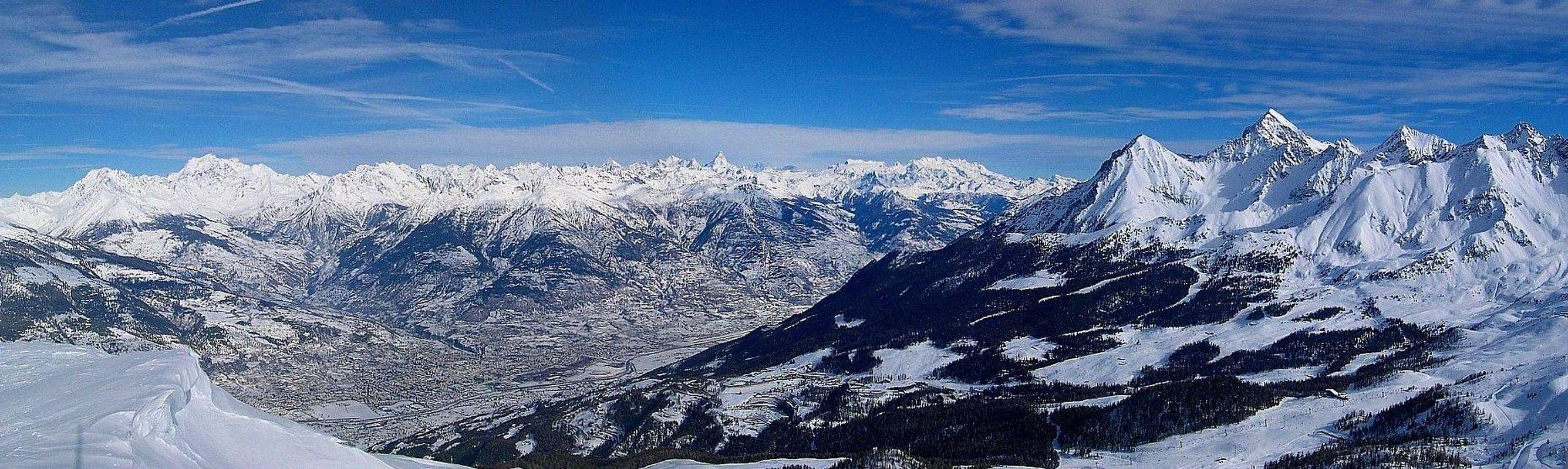
First summit on the ridge dividing the Val di Cogne from the Pila Hollow, grassy on all its sides but the E-NE, one that is made by a broken rocks bank ending on a scree. On its summit a rustic and high wooden Cross. Very popular both in summer, as a fine panoramic hike, mostly with departure from Pila's Resort (1.800m around) and through the Oriental Slopes or the great North-northwest Ridge (easy, but less popular for more and more complicated trail, at the least for the mid part of the route, inside and crossing the Liautaysaz's and Champchenille Woods). As it regards the part it always turns to the touring there is to observe that along the whole run that from the Point de La Pierre and up to the maximum peak of the Point of the Valletta (3.090m), apex of the coastline watershed that separates the Basin of Pila from the Valley of Cogne, and vice versa, since 2003 he has been equipped a Strong Street that at first has interested the slope in this last top departing from the Pass Tsasetze or Chasèche (2.815m) along his Crest progressively Southwest and then by extension up to the point in matter, with the paths 4A up to the Hill of the Drinc (2.565m) and subsequently n° 1 up to that that is known, with popular name, but improper, as "La Pera" (= "The Pear"); certainly he has already facilitated the elementary run in existence widening it same to the mass. For against he has removed from him some his charm or at least the inventiveness to find the passages along the trail; they are splendid however the sights along the whole crossing and I beter and better glorify the glimpse on the glacial Wall Northeast of the Grivola, that is risen really before with great stateliness & impressiveness. In winter and spring when many ski-mountaineers come to amuse, above all along the easy Northwestern Slope with departure from few over the Village of Ozein (1.363m); exactly to the alternative 1.490 m around immediately over the Fraction of Dailleu (1480m), where the dirt road "poderale" departs for the Alps of Romperein also called Rond Perrin (1.867/70m) and the following one of Champchenille (2.212m). Or, continuing through still the Regional Road up to the neighbor Turlin Dessus (1.521m); = than Above), through the path n° 1 reaching the superior "Alpeggi" of La Prému (1.554m) and of Savoyon (1.611m) and, crossing the Bois de Cote-Noire, so again reaching Romperein. In this last decade, with the rediscovery of this ancient equipment, he has also become of fashion the route through the snow rackets; logically those modern in plastics and with so much of small harpoon applied in the anterior part, that the old models replace in wood and rope, surely less profitable for the slope, since heavier, and that they often formed a big "sabot" (= snow's clog) or they untied him going out out of the foot, such factors to let the poor mountain climber to come the nervous breakdown.
Prima vetta della costiera divisoria fra la Val di Cogne e la Conca di Pila, erbosa su tutti i fianchi tranne quello E-NE, dove presenta una scarpata di rocce rotte sulla sottostante pietraia. Sulla cima è posta una alta e rustica croce in legno. Molto frequentata nella bella stagione come cima escursionistica, soprattutto dal lato Orientale con partenza dal Centro Turistico di Pila (1.800 m circa) oppure lungo il Crestone Nord-nordovest (facile ma molto meno frequentato, anche per la ricerca del percorso sicuramente maggiormente complicato e complesso almeno nella parte mediana, all'interno e nell'attraversamento dei Bois de Liautaysaz e di Champchenille). Per quanto concerne la parte rivolta sempre all'Escursionismo v'é da osservare che lungo tutto il percorso che dalla Punta de La Pierre e fino alla vetta massima della Punta della Valletta (3.090 m), apice della costiera spartiacque che separa il Bacino di Pila dalla Valle di Cogne, e viceversa, dal 2003 é stata attrezzata una Via Ferrata che dapprima ha interessato la salita a quest'ultima cima partendo dal Colle Tsasetze o Chasèche (2.815 m) lungo la sua Cresta Sudovest e poi progressivamente é stata estesa fino alla punta in questione, con i sentieri 4A insino al Colle del Drinc (2.565 m) e successivamente n° 1 fino a quella che é conosciuta, con nome popolare, ma improprio, come "La Pera". Certamente ha facilitato il già elementare percorso in esistenza, allargando lo stesso alla massa. Per contro gli ha tolto un poco del suo fascino o per lo meno l'inventiva di ritrovare i passaggi lungo la via; permangono comunque splendide le viste lungo l'intera traversata e più che magnifico il colpo d'occhio sulla glaciale Parete Nordest della Grivola, ergentesi proprio là davanti dirimpetto ed in tutta la sua imponenza. In inverno e primavera è un'ottima gita scialpinistica frequentata da moltissimi sciatori, soprattutto lungo il facile Versante Nordoccidentale con partenza da poco oltre il Villaggio di Ozein (1.363 m); esattamente al bivio 1.490 m circa subito oltre la Frazione di Dailleu (1.480 m), ove si diparte la strada poderale per gli Alpeggi di Romperein o Rond Perrin(1.867/70 m) ed il successivo di Champchenille (2.212 m). Oppure, proseguendo ancora per mezzo della Strada Regionale fino al vicino Turlin Dessus (1.521 m; = di Sopra), tramite il sentiero n° 1 raggiungendo le soprastanti Alpi di La Prému (1.554 m) e di Savoyon (1.611 m) ed, attraversando il Bois de Cote-Noire, arrivando così nuovamente a Romperein. In questo ultimo decennio, con la riscoperta di quest'antica attrezzatura, é diventata di moda anche la percorrenza tramite le racchette da neve; logicamente quelle moderne in plastica e con tanto di piccolo rampone applicato nella parte anteriore, che sostituiscono i vecchi modelli in legno e corda, sicuramente meno redditizi per la salita, poiché più pesanti, e che spesso formavano un grosso "sabot" (= zoccolo di neve) o si slegavano uscendo fuori dal piede, fattori tali da far venire l'esaurimento nervoso al povero alpinista.
First Ascents
First on the summit: Unknown.
In winter: Unknown.
Getting There
BY CAR:
From Torino, Milano, etc: Motorway A5. Exit in Aosta Ovest. Drive to the near Aymavilles. Follow in the direction of Valle di Cogne.
From Switzerland: through the Grand St. Bernard Tunnel or the homonym Pass). Drive to Aosta, then follow Courmayeur direction on SS.26. Just after Sarre, turn to the left, in the direction of Valle di Cogne.
From France: through Mont Blanc Tunnel or Petit St. Bernard Pass). It isn't necessary to enter in Motorway A5, you can drive through SS.26 Aosta direction. Before arriving at the Village of Sarre, follow the sign and turn right towards Valle di Cogne.
BY PLANE:
Aeroporto "Corrado Gex" Saint Christophe (Aosta).
Approaches and Routes A & B (from Ozein Village and Pila Resort)
Route A: from Ozein Village in Commune of Aymavilles. To get the starting point (the small Village of Ozein - 1.363m) you have to drive from Aymavilles (640m; splendid castello property before of Aymavilles Lords and afterwards ownership of those Challant), along the SR.47 of Val Di Cogne, till the fork that, on the left, leads to the village, after having previously left an alternative on the right (West) for Pondel or Pont of Ael (890m), suspended Village in the gorges of the River Grand'Eyvia and famous for his Roman Bridge dated 3 to. Christ (880m). Before reaching Ozein Village, (1.332m; Veeulla 1.349m; Parking in place near Belley 1.369m), the road it passes near a characteristic cave with different small votive devoted to the Madonna (small area picnic with chairs and table in wood with near tiny fall of stream coming from the near of an enough frequented and near gym of calcareous rock. From Ozein you can go on, along the road to Turlin High and Low, till a fork on the right side, wherefrom starts the farm road, (concomitant with the path n° 1; see in detail Overview), leading to the mountain Pastures of Romperein (1.870m) and to the next one (Champchenille - 2.168m). This, of course if the road is free, normally in winter you have to start from Ozein and get this point along some short cuts, avoiding the 7 km of the road. From Champchenille, ascending on fine slopes, straight to the Summit, by foots, ski or snowshoes. Time to go from Ozein: 3h'00/4h'00.
Descent: along the same route. From the summit (and almost the whole route) you can enjoy a wonderful panorama on Val d'Aosta mountains, in particular on the Grivola.
Via A: dal Villaggio di Ozein nel Comune di Aymavilles. Il Villaggio di Ozein (1.363 m) è raggiungibile da Aymavilles (640 m; splendido castello prima di proprietà dei Signori di Aymavilles, dopodiché di quelli di Challant) risalendo la SR.47 per la Valle di Cogne sino al bivio della località, dove si svolta a sinistra, dopo aver lasciato precedentemente un bivio sulla destra (Ovest) per Pondel oppure Pont d'Ael (890 m), Villaggio sospeso nelle gorge del Fiume Grand'Eyvia e famoso per il suo Ponte Romano datato 3 a. Cristo (880 m). Prima di raggiungere Ozein la strada passa nei pressi di una caratteristica grotta con diverse piccole state votive dedicate alla Madonna (piccola area picnic con sedie e tavolo in legno con vicino cascatella di torrentello proveniente dai pressi di un'abbastanza frequentata e vicina palestra di roccia calcarea. Dal Villaggio di Ozein, (1.332 m; Veulla 1.349 m; Parking nella piazzetta presso la località Belley 1.369 m), continuare per la strada di Turlin Dessus e Dessous insino al bivio sulla destra dove inizia la strada poderale (concomitante con il sentiero n° 1; vedi nel dettaglio in Overview), che conduce all'Alpeggio di Romperein (1.870 m), proseguire sino all'Alpe di Champchenille (2.168 m); si può salire anche per scorciatoie evitando i 7 km della strada poderale. Di qui puntare, su splendidi pendii, senza percorso obbligato alla Vetta, che si raggiunge a piedi, con gli sci o in racchette da neve. Tempo di salita da Ozein 3h'00/4h'00.
Discesa: lungo la via di salita. Dalla vetta si gode un panorama grandioso sulle grandi montagne della Valle d'Aosta, in particolare sulla Grivola.
Route B: from Touristic Center Pila Resort in Gressan Municipality. From the Center Touristic of Pila (attainable from the City of Aosta through the Regional Road that from the Bridge Suaz (567m) above the River Dora Baltea climbs to the inhabited area of Charvensod (746m) for then to continue, through a whole small series of fractions of this Municipality, reaching at first Péroulaz (1.359m) to the border with Gressan and then Les Fleurs (1.414m), already inside this last. Touching in progression the Villages of the Petite and the Grande Cerise, Eaux-Froides, Charémoz, Bettères and Perchu the same one reaches the center of Pila (1.800m around). Also, always pivot of reference the Pont Suaz to climb up to Les Fleurs with the road that, long the same Stream, it reaches the Commune of Gressan (600m about). From the rotunda really in front of the Commune, between the inhabited areas of Taxel and Chez the Rus, to go up again at first toward Southeast among a series of small scattered fractions, but adjacent; then to a first winding road to form of elbow the same one clearly changes direction in East and, doubling the characteristic Hill of the Gargantua * (= the Giant Hill in the popular imagination, but in reality basal moraine to iron form from i stretch residual of the ancient Glacier of entire Pila Basin, by now from thousand of years extinguished, that here he connected with the huge Glacier Balteus) the same one reaches the Village of Plan David (745m) and subsequently with a series of wide windings road those of Perriail, Champlan Dessous, Leysettaz, Champlan Dessus, Barrier, Tivet and Gerdaz (1.340m; intermediary station of the Cableway Aosta/Pila) that it discards as soon as on the left. With other two windings the same reaches Les Fleurs to the conjunction with the preceding Regional Road, from where whence to Pila. From Pila, through the great tunnel in cement, to reach the breadth superior square-parking lot (1.870m), where he leaves the car, since all the roads "poderali" in dirt earth to follow introduces the poster of prohibition. From this to reach an i cross of three roads poderali, site between Gorraz and Gorraz Damon, taking that middle, concidente with the path n° 23 and to follow it with direction Southwest (abundant posters and signals). Passing below the Cableway Gorraz/Leissé Damon, to reach at first the Pasture of Lap ((2.076m), that he leaves as soon as on the left, introducing then himself in the homonym wood; reaching Grand Grimod Dessous (2.158m), where a new triplex intersection of paths happens (to the right or North for the Grimondet (2.105m) and to the left or Southeast for the Grand Grimod Dessus (2.232m ; arrival of the "Funivia"). To continue instead among the two with the path n° 23A toward the hairpin bend 2.294m , just below the Chair lift that from the Alp Grivel reaches it as soon as above; changing direction in South to reach the small station of arrival and to continue through backs meadow and small basins grassy-debris. To reach an assistant under the Collar de the Pierre (2.600m around) and, through a steep but brief line, to reach the same one along his Slope East-northeast. Folding up to the right or Northwest to reach the homonym Hill (2.594m) and easily with the path n° 23A/1, along the Crest Southeast, with almost level and old run a small rocky line on the right, to reach the tall and thin Cross in wood posts on the Summit E or BSA; 0h'20 from the pass; 3h'00 from Pila Resort).
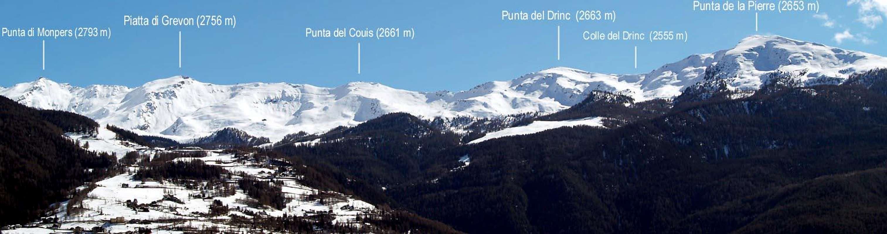
The long crest watershed between Pila Resort and the initial part of Cogne Valley among Gressan/Aymavilles/Cogne Municipalities and from of La Pierre (2.653m) to of the Valletta Points (3.090m)
Via B: dal Centro Turistico del Domaine Skiable di Pila nel Comune di Gressan. Dal Centro Turistico di Pila (raggiungibile dalla Città di Aosta tramite la Strada Regionale che dal Ponte Suaz (567 m) sopra il Fiume Dora Baltea sale all'abitato di Charvensod (746 m) per poi proseguire, attraverso tutta una piccola serie di frazioni di questa Municipalità, raggiungendo dapprima Péroulaz (1.359 m) al confine con Gressan e poi Les Fleurs (1.414 m), già all'interno di questo ultimo. Toccando in progressione i Villaggi della Petite e della Grande Cerise, Eaux-Froides, Charémoz, Bettères e Perchu la stessa raggiunge il centro di Pila (1.800 m~). Oppure, sempre perno di riferimento il Pont Suaz salire fino a Les Fleurs con la strada che, lungo la Dora, raggiunge il Comune di Gressan (600 m~). Dalla rotonda proprio davanti al Comune, tra gli abitati di Taxel e Chez le Ru, risalire dapprima verso Sudest tra una serie di piccole frazioni sparse, ma adiacenti; poi ad un primo tornante a forma di gomito la stessa cambia nettamente direzione in Est e, doppiando la caratteristica Collina del Gargantua * (= Collina del Gigante nella fantasia popolare, ma in realtà morena basale a forma di ferro da stiro residuo dell'antichissimo Ghiacciaio dell'intero Bacino di Pila, ormai da migliaia di anni estinto, che qui si congiungeva con l'immane Ghiacciaio Balteo) la medesima raggiunge il Villaggio di Plan David (745 m) e successivamente con una serie di "tornantoni" quelli di Perriail, Champlan Dessous, Leysettaz, Champlan Dessus, Barrier, Tivet e Gerdaz (1.340 m; stazione intermedia della Funivia Aosta/Pila), che scarta appena sulla sinistra. Con altri due tornanti la stessa raggiunge Les Fleurs alla congiunzione con la precedente Strada Regionale, donde a Pila. Da Pila, tramite il grande tunnel in cemento, raggiungere il largo piazzale-parcheggio superiore (1.870 m), dove si lascia l'automobile, poiché tutte le strade "poderali" in terra battuta a seguire presentano il cartello di divieto. Da questo raggiungere un'incrocio di tre strade poderali, site tra Gorraz e Gorraz Damon, prendendo quella di mezzo, concidente con il sentiero n° 23 e seguirla con direzione Sudovest (abbondante cartellonistica). Passando al di sotto della Funivia Gorraz/Leissé Damon, raggiungere dapprima l'Alpe di Lap ((2.076 m), che si lascia appena sulla sinistra, introducendosi poi nell'omonimo bosco; raggiungendo Grand Grimod Dessous (2.158 m), dove avviene un nuovo triplice incrocio di sentieri (a destra o Nord per il Grimondet (2.105 m) ed a sinistra o Sudest per il Grand Grimod Dessus (2.232 m; arrivo della Funivia)). Continuare invece tra i due con il sentiero n° 23A verso il tornnte 2.294 m,proprio al di sotto della Seggiovia che dall'Alpe Grivel lo raggiunge appena al di sopra; cambiando direzione in Sud raggiungere la piccola stazione di arrivo e proseguire attraverso dossi prativi e piccole conche erboso-detritiche. Raggiungere una valletta sotto il Colletto de la Pierre (2.600 m circa) e, tramite un tratto più ripido ma breve, raggiungere il medesimo lungo il suo Versante Est-nordest. Piegando a destra o Nordovest raggiungere l'omonimo Colle (2.594 m) e facilmente con il sentiero n° 23A/1, lungo la Cresta Sudest, con percorso quasi pianeggiante e superato un piccolo tratto roccioso sulla destra, raggiungere l'alta e scarna Croce in legno posta sulla Sommità E o BSA; 0h'20 dal colle; 3h'00 da Pila).
Difficulties
The rating is easy (hiking or E) or BSA (Ski-Mountaneering) and besides for Expert Trippers (EE), by snowshoes.
Le difficoltà sono da valutare come facile escursione od E oppure gita per Buoni Sciatori Alpinisti (BSA) ed inoltre per EE con racchette da neve.
Equipment
Mountaineering equipment, according to season; by Ski or snow's rackets.
Classico da media montagna, secondo la stagione; da Sci-Alpinismo o con racchette da neve.
Campings
Remember that free camping is forbidden (except for emergency reasons, over 2.500m, from darkness until dawn).
Mountain Condition
Meteo: you can find all the needed informations at the official site of the Valle d'Aosta Region:
"Racchette da Neve a Cogne", di Ezio Savin e Luca Zavatta, l'Escursionista Editore, Novembre 2003.
"Guida del Monte Emilius", di Osvaldo Cardellina, Musumeci Editore, 1978.
"Pelli di Foca in Valle d'Aosta", di Franco Lenzi Editoriale Pedrini Torino, 1988.
"Le Racchette da Neve" di Alessandro Leonardi e Marco Seghezzi, Ed. Takes, 2001.
"Gite in Sci" di Remo Grigliè, Ed. Teca Torino, 1962.
"Guida dei Monti d'Italia, Emilius Rosa dei Banchi Parco del Mont Avic", di Giulio Berutto e Lino Fornelli - Club Alpino Italiano/Touring Club Italiano, Aprile 2005.
"Scialpinismo in Valle d'Aosta", di Pietro Giglio e Emile Noussan. Musumeci Editore, 1993.
"80 itinerari di Escursionismo Alpinismo e Sci Alpinismo in Valle d'Aosta", di Osvaldo Cardellina, Ed. Musumeci, Giugno 1977 (in Italian); seconda Ed. Luglio 1981; terza Ed. Luglio 1984; (in French), prima Ed. Febbraio 1978; seconda Ed. Marzo 1980.
"Diari Alpinistici" di Osvaldo Cardellina e Indice Generale accompagnato da Schedario Relazioni Ascensioni 1964-2019 (inediti).
MAPS:
Kompass "Gran Paradiso Valle d'Aosta Sentieri e Rifugi" Carta turistica 1:50.000.
Hapax Luglio 2000 "Les Sentiers Comunità Montana Monte Emilius" 1:25.000.
L'Escursionista "Conca di Aosta-Pila-Monte Emilius" Carta dei sentieri (n° 4) 1:25.000.
I.G.C. Istituto Geografico Centrale, Torino "Carta delle Passeggiate ed Escursioni in V.D.A. Conca di Pila-Gressan" 1:20.000.
Enrico Editore Ivrea-Aosta "Gruppo del Gran Paradiso" 1:50.000.
A.I.NE.VA. (Associazione Interregionale Neve e Valanghe).
A.IA.T. Cogne Gran Paradis via Bourgeois n° 34 Tel. 0165-74040. E-mail: aiat@cogne.org
Ezio Sport articoli sportivi - via Bourgeois n° 64 Tel. 0165-74204.
Useful phone numbers
Protezione Civile Valdostana località Aeroporto n° 7/A Saint Christophe (Ao) Tel. 0165-238222.
Bollettino Meteo (weather info) Tel. 0165-44113.
Unità Operativa di Soccorso Sanitario Tel. 118.
Acknowledgements
I am greatly indebted to my friend "Osva" for the detailed description of all texts and the translation of Route B. In addition I want to thank Gabriele Roth for the translation of the text from italian.
Parents refers to a larger category under which an object falls. For example, theAconcagua mountain page has the 'Aconcagua Group' and the 'Seven Summits' asparents and is a parent itself to many routes, photos, and Trip Reports.

 10044 Hits
 93.1% Score
 41 Votes