
|
|
Mountain/Rock |
|---|---|
|
|
38.91490°N / 106.437°W |
|
|
13951 ft / 4252 m |
|
|
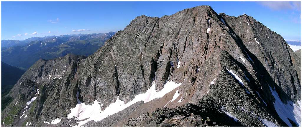
Standing guard over the historic mining town of Winfield Colorado, deep in the heart of the Sawatch Range, Ice Mountain (13,951-ft) and its neighboring North Apostle (13,860-ft) and West Apostle Peak (13,568-ft) form the forbidding, but spectacular Three Apostles massif. Ice Mountain is the central and highest mountain of the group. All three summits are located on Colorado’s Continental Divide. At 13,951-ft, Ice Mountain easily makes the 13,800-ft centennial thirteener category, Colorado’s 100 highest mountains. Its location is central, evidenced by as many as 15 other centennial mountains within 20 miles.
Ice Mountain sure is one beautiful mountain to look at. A view from Winfield or even the summit of the nearby 14er Huron Peak will knock your socks off. Ice Mountain proves that descriptive words like “steep,” “rugged,” and “rotten” can be beautiful to photograph, that’s why a brilliant shot of Ice Mountain graces the cover of the popular centennial thirteener book by author Gerry Roach. Looking beautiful doesn’t necessarily equate to good climbing. Unfortunately, Ice Mountain is currently falling apart faster than the rock misile flying down its east face. This is a rotten, and dangerous mountain.

Ice is not your typical Sawatch Range mountain. Don’t expect gentle slopes and broad ridges leading to a large summit plateau, consistent with nearby, Mount Huron or Mount Hope. Expect tedious bouldering, difficult route finding, and steep class 4 climbing, similar to Pyramid Peak or the Maroon Bells. I would venture to say that Ice Mountain has about 20-ft of climbing that either the Maroon Bells or Pyramid cannot match via their standard routes.
That being said, Colonalpyat and I both agree that Ice Mountain was not as difficult as advertised. Due to the excess of varying trip reports, Ice initially made me apprehensive. Don’t get me wrong, at one point during the crux of the climb I found myself in a precarious position that didn’t feel very comfortable. But, overall the technical difficulties with proper route finding do not exceed dangerous, exposed class 3.
Because of the route finding difficulties in the upper gully, most get involved with exposed, committing class 4 climbing on dangerous rock. Finding the proper route will be the key to a fulfilling and safe day on Ice Mountain. I forgot to mention that the Three Apostles Massif has a reputation for a confusing approach as well as an abundance of poor climbing weather. My route description will address the approach in detail but I can’t do much for the bad weather, you will just have to do a 4:00 a.m. start.
The Three Apostles rest within the backbone of the Colorado Continental Divide, the Sawatch Range. This complex range stretches nearly 100 miles north and south, starting at Tennessee Pass and ending at the Marshall Pass area. The Sawatch is home to 15 fourteeners and 14 centennial thirteeners; no other Colorado mountain range contains as many peaks above 13,800 ft. The Sawatch Range can be split up into three areas; the Southern Sawatch, Central Sawatch-where Ice Mountain resides, and the Northern Sawatch. When hiking the central Sawatch Range, there are a few things you can count on, long approaches, plenty of vertical gain, and endless class 2 hiking.
The Northeast Ridge Route

Photo by Colonelpyat
First, realize that the crux of this climb involves steep class 4 climbing in a north-facing couloir. This couloir retains snow all the way into middle to late July. If you climb Ice before late July come prepared to use your ice axe. This couloir is steep; a slip here on snow or mud could be fatal. Wear a helmet for this climb.
Second, if at all possible, drive to the TH the night prior to your climb. In fact, drive the 4wd road to save you the additional 4 miles of RT. The weather in and around the Three Apostles has a reputation for fast cloud build-up. If you’re climbing Ice during the monsoon season (middle July-late August) get an early start, like 4:00 a.m. I would start by figuring out a time to be on the summit. Jim and I knew we needed to be on the summit no later than 9:00 am, and a 4:00 a.m. start would guarantee that for climbers of our abilities. Knowing your speed and climbing ability will be big factors in determining your success.
Third, if you are using Roach’s excellent thirteener book for the approach to Ice, you may get lost on the approach. This is the only route description that I know of in the book to have incorrect route beta. Both the approach and the route description up the crux gully is incorrect. His description of climbing the right side of the gully works with exposed class 4 climbing, which he describes as class 3. But the easiest route up this gully is on the left side, and this makes it mostly class three scrambling with one or two class 4 moves with minimal exposure. Also, Roach’s topo map (pg 132)is off; it shows the Three Apostles Trail ascending the east (left) side of the South Fork of Clear Creek. The actual approach route, ascends the west (right) side of the creek. This is a big mistake for the creek rushes down a small gorge of sorts and crossing it to get to the other side would be very difficult.
Round Trip-from 4wd parking-7.7 miles & 3,371-ft
Round Trip from South Winfield TH-11.7 & 3,731-ft
Round Trip with an ascent of North Apostle-add 420-ft.
 |
 |
 |
 |
 |
4wd parking past South Winfield TH
Take Chaffee County 390 west from Hwy 24 (15 miles north of Buena Vista, 19.3 miles south of Leadville.) County 390 is an improved dirt road that passenger cars can use. Continue 11.8 miles on 390 until you reach the historic mining town of Winfield. Go left at the intersection (south) in Winfield and drive for .3 miles to the South Winfield Trailhead. There is parking here for about 10 cars. If you have a good 4WD you can drive 2 more miles up the 4WD drive road and cut about 4 RT miles off the climb. This 2-mile section of 4wd is not too technical or difficult but should only be attempted with high clearance vehicles.
Credits
- Colonalpyat-great climbing partner.
- Dave C-Thanks for the approach beta one year ago on 14erworld.
- Bob Dawson-thanks for the route beta one year ago on 14erworld.
- Kurt Traskos-thanks for drawing up a topo for me a year ago on 14erworld that I printed and used the day of my recent climb.
Mountain Conditions
- Colorado Avalanche Information Center (CAIC)
- Mount Elbert Web Cam
Click image to enlarge
Click here to view a 7-day forecast for the area surrounding the historic mining town of Winfield
When To Climb
Realize that the crux of this climb involves steep class 4 climbing in a north facing couloir. This couloir retains snow all the way into middle to late July. If you climb Ice before late July come prepared to use your ice axe. This couloir is steep, a slip here on snow or mud could be fatal. Please wear a helmet for this climb.
San Isabel National Forest
- No permits or fees are required to climb or hike.
- MAPS San Isabel National Forest
USGS 7.5 minute quadrangle: Winfield
Trails Illustrated #129 Buena Vista/Collegiate Peaks - Leadville Ranger District
2015 North Poplar - Leadville, CO - 80461
Phone (719) 486-0749
Fax (719) 486-0928
Chaffee County Road 390-Camping
Free camping is available along County 390 from highway 24 to the 4wd trailhead. There are no formal campgrounds on 390, just primitive campsites, and many of them. Many have fire rings and are near a creek. There are abundant places to car camp along 390 as well as plenty of space at the 4wd trailhead.
Matt Lemke - Feb 8, 2012 6:21 pm - Voted 9/10
Peaks above 13,800 feetYou stated: no other Colorado mountain range contains as many peaks above 13,800 ft However the San Juans definitely have more than the Sawatch