
|
|
Mountain/Rock |
|---|---|
|
|
36.05357°N / 51.55064°E |
|
|
Mountaineering |
|
|
Summer |
|
|
14190 ft / 4325 m |
|
|
Overview
Click for Introduction to the Central Alborz Mountains.Click for Introduction to Kholeno Massif.
Click for a detailed map of the Central Alborz Mountains.
Click for a detailed map of the Kholeno Massif.
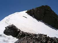
 North slopes of South Peak North slopes of South Peak | 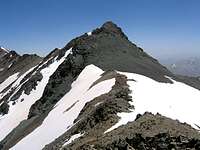 South Slopes of South Peak South Slopes of South Peak |
 North Slopes of North Peak North Slopes of North Peak | 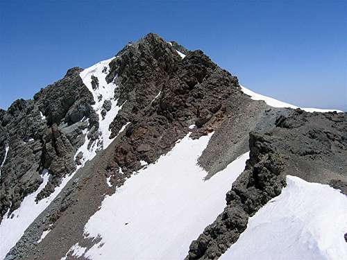 South Slopes of North Peak South Slopes of North Peak |
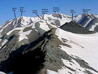
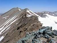
On the crest of the ridgeline south of the Kholeno Peaks (Kholeno the Great & Kholeno the Small) in the Central Alborz Mountains of northern Iran, you will find two rocky peaks. The north peak is known as Borj. The south peak is not mentioned in any source that I am aware of. Even the 1:50 000 map, which is the most accurate map of the area, fails to show the south peak. The elevation of the north peak is 4325 m. The elevation of the south peak is not known but it seems to be slightly lower than the north peak. Due to its sharp appearance from some angles, the south peak is sometimes confused with the nearby Jhandark Needles. In this discussion, I will refer to these peaks as the North Borj and the South Borj Peaks.
In Persian "Borj" means "Tower". These peaks are so called because from certain angles, they appear as rocky towers. This is most notable from the west where the slopes of the Borj Peaks make walls that drop more than 200 m into a fairly large alpine cirque. The cirque sits at an elevation of 3800 to 4100 m and houses a seasonal lake known as Kholeno Lake. To the north, the Borj Peaks connect to the 4350 m Kholeno the Small Peak (via the Jhandark Needles). The eastern slopes of the Borj Peaks are scree covered and go down to a 3970 m saddle that connects to a series of high points known as the Varzab Peaks (4036 m). To the southwest, Borj is connected to the 4268 m Harzeh Kooh Peak.
Borj can be climbed via 3 different routes (Roundtrip for the first two routes is one to one and a half days. The third option is multi-day). Some scrambling might be needed below the summits but no technical skills are required.
- Via the village of Laloon (2400 m) to the southeast. From Laloon you will hike a beaten path to the 3970 m saddle with the Varzab Peaks and then go up the eastern slopes of the Borj Peaks.
- Via the summit of the 4210 m Sarakchal Peak (starting from the 2600 m village of Shemshak). From the summit of Sarakchal you will descend the northern slopes of Sarakchal to a 3910 m saddle, bypass or climb Peak 4018 m, then go up the southern slopes of the 4268 m Harzeh Kooh Peak to reach its summit. From the summit of Harzeh Kooh, you will follow the ridgetop northwest to reach the Borj Peaks.
- Via the Varengeh Rood Village (2450 m) to the northwest. This is the longest, but probably the more scenic route. From Varengeh Rood Village you will hike 21.5 Km (13.3 miles) along the length of the Varengeh Rood River to reach the Kholeno Lake (3830 m) where you will find a perfect spot to set up your base camp (The hike will take you past the remains of monstrously large winter avalanches and provide you with spectacular views of snow-capped peaks and alpine meadows). From your base camp, you will then be able to access many of the local peaks (For more details, see " From Varengeh Rood" route).
Most people who come to the Borj Peaks continue north to reach the 4387 m summit of Mt. Kholeno the Great. Many sources refer to the Borj Peaks as "Borje Kholeno" which translates as "The tower of Mt. Kholeno". The Borj peaks, however, are independent peaks with much prominence and distance from Mt. Kholeno the Great.
 East Slopes East Slopes |  West Slopes West Slopes |
 (L) North & (R) South Borj Peaks from Kholeno Lake
 North (Kholeno) North (Kholeno) |  East (Damavand) East (Damavand) | 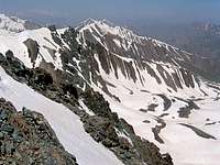 West (Kherschal) West (Kherschal) |
Getting There
| Directions to Varengeh Rood Village | From downtown Tehran drive the Tehran-Karaj Freeway 40 Km west to the town of Karaj and take the Chalus Road exit. Drive the Chalus Road up the mountains roughly 70 Km till the junction of the road that goes to Dizin Ski Area (2250 m). Turn onto this road and follow it a few Km till you see a side road on the left that goes to Varengeh Rood Village (2325 m). Turn onto this road and follow it a few Km till the end of it at the village (2450 m). |
| Directions to Laloon Village | From northeastern Tehran, take the Babai expressway east and then take the Lashgarak expressway north up to Ghoochak Pass (1950 m). Follow the road north down the many switchbacks to the bottom of the Jajrood River Valley (1700 m). Drive 20 Km north to the main square in the village of Fasham (1950 m). Left (west) will take you to the ski resorts of Shemshak and Dizin. Turn right (east) and drive 7 Km to the village of Zaygan (2250 m) and then turn left (north) and drive a side road about 4 Km to the village of Laloon (2400 m). |
| Directions to Shemshak Village | From northeastern Tehran, take the Babai expressway east and then take the Lashgarak expressway north up to Ghoochak Pass (1950 m). Follow the road north down the many switchbacks to the bottom of the Jajrood River Valley (1700 m). Drive 20 Km north to the main square in the village of Fasham (1950 m). Right (east) will take you to Laloon & Garmabdar Villages. Turn left (west) and drive 13 Km past the Meygoon Village to reach the village (and ski resort) of Shemshak (2600 m) |
Red Tape
| The Alborz Mountains are a protected area. Huntimg and fishing are prohibited |
| No fees or permission is required for climbing or camping |
| You can camp anywhere |
When To Climb
| Best | Late spring and early autumn (June, July, September and October) |
| My Favorite Time | Mid to late June when there is still much snow at the higher elevations, the grass in the valleys is green and flowers are in bloom |
 From Kholeno From Kholeno | 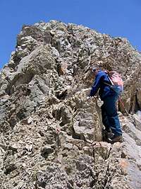 Below Summit Below Summit |  Alpine Cirque Alpine Cirque |
Mountain Conditions
| Summer (June-October) | The weather is generally clear. Isolated thunderstorms do occur. Precipitation at higher elevations can be in the form of snow/sleet. |
| Winter | Cold, heavy snow, unstable snow-banks, danger of avalanche, strong winds . |