
-
 15319 Hits
-
 88.19% Score
-
 26 Votes
|
|
Mountain/Rock |
|---|---|
|
|
44.41330°N / 110.1466°W |
|
|
Park |
|
|
Hiking, Mountaineering, Scrambling |
|
|
Summer, Fall |
|
|
10656 ft / 3248 m |
|
|
Overview
 Mount Doane
Mount Doane is one of Yellowstone Park's grandest and most beautiful mountains; it is rarely climbed due to a lack of trails near the peak and a difficult and long approach through some of the Park's wild backcountry, where meeting grizzlies face-to-face is common and a wide variety of terrain types will test your skills as a hiker and climber. If you want adventure and the experience of going someplace it feels like you are the first person to visit, this would definitely be a mountain to consider.
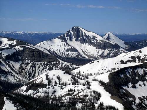
Visible to the vast majority of Yellowstone tourists only on the southeastern horizon across Yellowstone Lake, the peak reveals its impressive stature only to those who climb the popular Avalanche Peak trail, or from the summits of nearby mountains like Hoyt, Top Notch, or Grizzly Peaks. The mountain's distinctive pyramid shape and steep north face will catch the eye of any mountaineer, and to paraphrase Tom Turiano's Select Peaks of Greater Yellowstone, it dominates the eastern skyline of the Park like no other mountain.
At 10,656 feet, Doane is the 793rd-highest peak in Wyoming, and has a prominence of 996 feet. The mountain is named for Gustavus Cheyney Doane, a U.S. cavalry officer who, along with Henry Washburn and Nathaniel Langford, was one of the leaders of the first official exploration in 1870 of what was later to become Yellowstone Park. During that expedition, Doane's name was attached to the peak that later became Mount Schurz, but was transferred to the the peak we know today as Mount Doane by the Hayden Geological Survey in 1871.
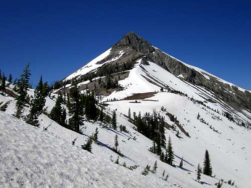
 Mount Doane from Hoyt Peak
Getting There and Climbing Information
 First creek crossing
The approach to this mountain is only five miles long, but it is very difficult and time-consuming due to the fact that even game trails are hard to come by and the terrain is so rough. It took me a good five hours to summit even though I’m a decently fast hiker; while I made some errors in the off-trail route-finding and could probably do it faster if I did it again, plan on getting an early start to avoid thunderstorms. A mountaineering axe is recommended for crossing the snow which may linger in the gullies into August in high snow years.
Begin your climb of Mount Doane from the parking area for the Avalanche Peak Trailhead, which is located about 8 miles inside the East Entrance to Yellowstone Park. There is a sign on the east side of the road, and the parking area is on the other side of the road next to Eleanor Lake. Rock hop or cross the small stream on a log on the parking lot side of the road and head south (left) on a game trail. The primary objective of the first two miles of hiking is to circumvent Top Notch Peak, so be careful not to veer to the right and ascend its northeast ridge; make sure to cross the creek that feeds Eleanor lake first before heading up to the east ridge of Top Notch, which leads to a small saddle overlooking a small bowl on the mountain’s southeast side.
 Grizzly track
 The summit
Cross through the bowl and make for the end of the ridge on the opposite side. From here you will have a good view of Doane as well as your next goal, which is the 9400’ saddle connecting the south ridge of Top Notch to the long ridge leading towards the objective. Getting there is not as easy as it looks, as several drainages block your way. The first one (Middle Creek) is the deepest and hardest to cross; avoid loosing any elevation and consider maybe climbing a bit before you get there, as the scramble across becomes more of an obstacle the lower you go. Another option is to ascend to near the summit of Top Notch and descend the next ridge to the left, which leads directly to the saddle. However, it is a lot of extra elevation gain that you have to give back in a hurry.
This saddle is a crossing point between drainages for a lot of wildlife, and there were at least three different sets of grizzly tracks, ranging in size from seven inches to almost a foot long. While I climbed this peak solo, I had many second thoughts about the wisdom of doing so after seeing all of the footprints, but I was fortunate to avoid the bears during my excursion! From here, there are two options for making the climb; the Class I northwest ridge is slightly shorter and easier, while the Class II/III northeast ridge is harder and has more fun scrambling. I traversed the peak in a loop from east to west on my outing, which added variety and interest to the climb.
 Doane's northeast ridge
Northeast Ridge
 The ramp
 Looking down the northeast ridge
To climb the more challenging northeast ridge, continue up to the top of the ridge leading south from the saddle, and continue along this ridge for a couple of miles until you are able to veer right towards Mount Doane. Crossing the last gully before making the ridge turn can be a little challenging, and you may want to either stay very high on top of the ridge or go low and drop into the basin to your right to avoid it.
Once you are on the northeast ridge, climb scree up to the cliffs which loom ahead. There is a ramp of loose rock that traverses to the left along the bottom of the cliffs, after which you will need to make a few Class 3 moves to make your way around and over a couple of gullies to the south side of the peak. From here, climb the last couple hundred feet of loose rock and talus to reach the summit, which is on the east side of the short summit ridge. There are cairns on both ends of the ridge.
 Summit view south
Northwest Ridge
 Typical terrain through the burned forest
 Doane's northwest ridge
This route involves descending about 600 feet from the saddle down through the bowl that holds the headwaters of Columbine Creek on the north side of Doane; this whole area is burned, and the travel is not difficult for the most part, but in some areas you have to contend with bogs and a lot of downed timber. Stream crossings are easy and shouldn't ever be a problem because of the numerous logs that have fallen across the creeks. Ascend to the gentle ridge on the far side of the bowl, which leads directly to the summit. If you climb the peak early in the summer, getting around the huge corniced bank of snow that lingers into late season may be difficult without an axe, so come prepared.
 The summit
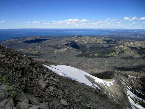
The top offers commanding views of Yellowstone Lake, the Tetons, and the huge sea of Absaroka summits to the east. To the south you can look out over one of America's largest roadless areas, which reaches across over 40 miles of wilderness.
A climb of Mount Doane by the northeast ridge entails 5.0 miles of off-trail travel with about 3000 feet of elevation gain. The northwest ridge route is just over 4.5 miles with 3300 feet of elevation gain.
 Looking over Mount Stevenson and Yellowstone Lake to the Tetons
Red Tape and Camping
Entrance into Yellowstone park will run you $25, or you can buy a year pass for all National Parks for $80. It isn't a bad idea to check with the Park Service before you come for information regarding grizzly activity in the area that you are headed. In addition to both grizzlies and black bears, you will find mountain lions, wolves, and many other types of wildlife, so carry bear spray and know your rules for traveling in bear country. Grizzly bears go everywhere, including very high up; they hunt for moths at high elevations in the late summer months and are expert scramblers on scree and loose terrain.Backcountry camping is not allowed in Yellowstone Park without a permit. See the Yellowstone Park site for rules and information on obtaining permits.
 Looking down the northwest ridge
External Links
Mount Doane on WikipediaGustavus Doane
Mount Doane on listsofjohn
Yellowstone Park
TheMountainRabbit - Dec 27, 2023 7:20 am - Hasn't voted
Name Change: First Peoples MountainOfficial name has been changed to "First Peoples Mountain".