
-
 10513 Hits
-
 89.77% Score
-
 30 Votes
|
|
Mountain/Rock |
|---|---|
|
|
45.68957°N / 7.56426°E |
|
|
Mountaineering |
|
|
9865 ft / 3007 m |
|
|
Overview
|
Smart rocky (Mont Avic or Aü) needle between the Passes of Raye Chevrère (S) and Varotta (N): from SSE it looks like a big dolomitic tower. Though not the highest summit it is the most carachteristic summit of the range, giving its name to the Regional Park. No glaciers around but some small snow-ice spots on its N side. Even if hosting some difficult routes the not fine quality rock doesn't give climbing satisfaction. This secluded mountain overlooking a wild group with its ancient iron mines. Wonderful view to North on the Matterhorn, Monte Rosa and on the whole centre of the Aosta Valley, while to the West rise the opposite Subgroups of Mont Glacier, Punta Tersiva, Range Roèses and higher Emilius. 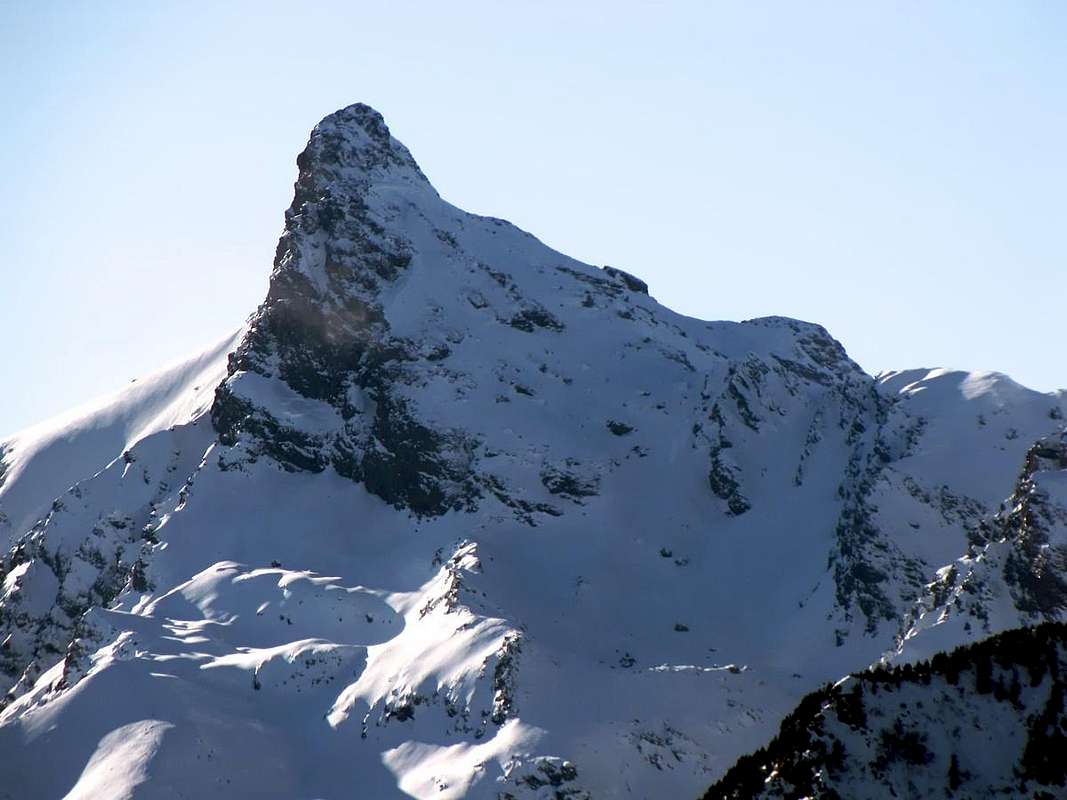 Elegante guglia rocciosa (conosciuta anche come Mont Aü, antica denominazione) a cavallo tra i Colli Raye Chevrère a S e Varotta a N; da S-SE appare più come grosso torrione dolomitico. Dà il nome al Parco Regionale del Mont Avic, pur non essendone la cima più elevata, ma sicuramente la più caratterizzante. Non possiede massa glaciale, tranne qualche glacio-nevato sul versante NE; la roccia di non buona qualità, non permette grandi soddisfazioni in arrampicata, anche se vi sono state tracciate vie impegnative. Questa montagna isolata domina un Gruppo selvaggio con le sue antiche miniere di ferro. Vista a 360° dal Centro Valle; panorami eccezionali sul Cervino e Gruppo del Monte Rosa, mentre verso Occidente dirimpetto si elevano i Sottogruppi del Mont Glacier, della Punta Tersiva, Catena delle Roèses e del più elevato Monte Emilius.
|
First Ascents
- First in the Summit (by NE Slope): Martino Baretti, Bovio, Santelli and three miners of Champdepraz, (Sep 24th, 1875), in ascent.
- In winter (through S Wall): Primo Tatto, Franco Berton Giacchetti, Enrico Rovarey and Antonio Mosso, (Dec 24th, 1972), in ascent.
- E-SE Wall (variant from NE Wall): Lino Binel and Amilcare Crétier, (Apr 08th, 1926), in ascent.
- E-SE Wall: Pietro Bosonetto and Elio Vittaz, (1982 or 1983), in ascent.
- S Wall (central route): Roberto Nicco and Alessandro Jaccod, (1970 years), in ascent.
- S Wall ("Quinto Sigillo" route): Giorgio Bredy and Paolo Marselli, (Feb 24th, 1997), in ascent.
- S Wall (left route): Giovanni Bobba and Casimiro Thérisod, (Aug 27th, 1904), in ascent.
- S Slope and S-SW Arête: Martino Baretti, Bovio, Santelli and three miners of Champdepraz, (Sep 24th, 1875), in descent.
- S Slope and S-SW Arête: Cesare Fiorio, Alfredo Fiorio, Ettore Canzio, Cesare Ratti, Felice Mondini and Nicola Vigna, (Oct 15th, 1893), in ascent.
- S-SW Arête (to Colle Raye Chevrère): Primo Tatto, Franco Berton Giacchetti, Enrico Rovarey and Antonio Mosso, (Dec 24th, 1972), in descent.
- S-SW Arête (integral from Colle Raye Chevrère): Osvaldo Cardellina, lone, (Jun 28th, 1987), in ascent.
- W Face (from Ponton Vallon): Osvaldo Cardellina, lone (May 29th, 2005), in ascent from Lusey.
- NW Edge (to Ponton Vallon): Osvaldo Cardellina, lone, (May 29th, 2005), in descent.
- N-NE Arête (normal from Varotta Pass): Unknown.
- N-NE Arête (integral from Colle Varotta): Osvaldo Cardellina, Emilio Bertona, Nicola Colajanni, Roberto Stella and Gianfranco Vicentini, (Aug 05th, 2001), in ascent.
Getting There
BY CAR:
- From Torino, Milano, etc: Motorway A5. Exit Verrès for then to continue on SS.26 toward Champdepraz.
- From Switzerland: through the Grand Saint Bernard Tunnel or the namesake pass. Drive to Aosta, Verrès and Champdepraz.
- From France: through Mont Blanc Tunnel or Petit Saint Bernard Pass. It isn't necessary to take Motorway A5: you can drive on SS.26, in the direction of Aosta and Verrès.
BY PLANE:
- Aeroporto "Corrado Gex" Saint Christophe (Aosta).
Approaches & Routes
A Route from North: From attainable Champdepraz from Verrès to the Village La Villa-Veulla (1.248m, car parking) along the road toward the "Magazzino" (warrehousing) up to the fork for Praz Orsie (or Pra Oursì), just beyond the Stream of Tréby (1.340m~); start ascending toward West crossing a stream then, near another fork, leaving to the right (North) the path to Pian Tsatsè, get the Praz Orsie Pasture. Following the same direction, crossing 3 small streams, get the ruins of the Fiè Pastures (2.080m) and along small hairpin bends, the upper Pian de Fiè (or Fì). Herefrom a narrow but well marked track toward SW leads to the slopes of the North-northeast side of Mont Avic. Climb them, on big stones and small snow spots: the steepness grows up to the final tower (almost 100m high) made of green-blue rocks. Finding the best way among narrow channels, debris ledges with tracks and some chimney and cracks, climb the summital triangle. Better starting from the left (East) ending to the right (difficulties between I° and III-° UIAA - 5h'00/6h'00 from Voella).
Descend or Route B: Along the West-southwest Ridge for less then 100 meters to the narrow notch 2.930m, bypassing to Northwest some steps enough exposed. From the notch down along a steep but tracked debris channel leading, to the foot of the South Wall, on a very wide debris ledge hosting many small lakes. To Southwest then to Southeast toward the Lago Gelato (Frozen Lake; 2.595m) Mines. Along a muletrack down to La Valey of Lac Gelé a Veulla (3h'00 for the descent; 5h'30/6h'15 in ascent from Voella or Veulla Hamlet).
 |
 |
 |
 |
 |
Via A da Nord: Da Champdepraz, raggiungibile da Verrès, alla Frazione di La Ville-Veulla oppure Voella (1.248 m, parcheggio), per la strada poderale verso il "Magazzino" sino al bivio per Praz Orsie o Pra Oursì, appena oltre il Torrente di Tréby a quota 1.340 m~; salire con direzione Ovest superando un primo torrentello e, nei pressi di un secondo ad un bivio, lasciare a destra (Nord) il sentiero per Pian Tsatsè raggiungendo l'alpeggio. Da Praz Orsie con la stessa direzione raggiungere, superando tre torrentelli, i ruderi dell'Alpe Fiè (2.080 m) e con piccoli tornanti (sorgente) il soprastante Pian de Fiè o Plan de Fì (da feyes o pecore); qui un'esile, ma ben in vista, traccia verso Sudovest porta alle pendici del versante Nord-nordest del Mont Avic. Per grossi blocchi e qualche nevato residuo, risalirlo con pendenze progressivamente in aumento sino alla torre finale di rocce verdi-bluastre, alta 100 m~; cercando il miglior passaggio tra muretti, canalini, cenge detritiche con tracce e qualche camino o spaccatura risalire il triangolo sommitale, abbastanza ripido, senza percorso obbligato. Conviene però tenersi dapprima a sinistra (Est) concludendo a destra (dal I° al III°- a seconda dei passaggi prescelti; 5h'00/6h'00 dal Villaggio di Voella).
Discesa nonché Via B: Scendere la cresta Ovest-sudovest per meno di 100 metri sino alla stretta forcella 2.930 m~ aggirando alcuni passi abbastanza esposti a Nordovest; da questa un canalino terroso-detritico ripido e con tracce porta verso la base della Parete Sud sino ad un enorme cengione detritico con numerosi laghetti. Percorrerlo verso Sudovest e poi Sudest in direzione delle Miniere del Lago Gelato (2.595 m); da questo per la mulattiera de La Valey du Lac Gelé a Veulla (3h'00 in discesa; 5h'30/6h'15 in salita dal Villaggio di Voella).
Difficulty
The route can be classified as PD- or PD.Corda e casco.
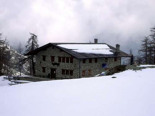
Huts
 |
Campings
Remember that free camping is forbidden (except for emergency reasons, over 2.500m, from darkness until dawn).Climbing Shots
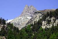
Southern Route B from Gelato Lake, generally regarded as Standard Route.
 |
 |
 |
 |
 |
Via Meridionale dal Lago Gelato, in genere frequentata come Via Normale.
Mountain Conditions
- You can get meteo information at the official site of the Regione Valle d'Aosta:
- Valle d'Aosta Meteo
Webcam
- WEBCAM on Aosta Valley:
- Webcam
Books and Maps
BOOKS:- "Guida delle Alpi Occidentali" di Giovanni Bobba e Luigi Vaccarone C.A.I. Sezione di Torino Volume II (parte II), 25 Maggio 1896.
- "Guida dei Monti d'Italia–Emilius Rosa dei Banchi Parco del Mont Avic" di Giulio Berutto e Lino Fornelli-Club Alpino Italiano/Touring Club Italiano, Marzo 2005 (in Italian).
- "A piedi in Valle d'Aosta" (Vol. 2), di Stefano Ardito, Ed. Guide iter, Giugno 2004.
- "I Rifugi della Valle d'Aosta" di Stefano Ardito, Ed. Guide iter, Febbraio 2003.
- "Rifugi e bivacchi in Valle d'Aosta", di Cosimo Zappelli aggiornata da Pietro Giglio, Musumeci Editore, Luglio 2002.
- "G. Klotz "Gran Paradiso" Ed. Bergverlag GmbH Rother, Monaco 2005 (in tedesco).
- "Guida della Regione Autonoma Valle d'Aosta" di Mario Aldrovandi; Ed. S.P.E. di Carlo Fanton, Torino 1964.
- "Diari Alpinistici" di Osvaldo Cardellina e Indice Generale accompagnato da Schedario Relazioni Ascensioni 1964-2019 (inediti).
- "Parco Naturale Mont Avic" di Naldo Finco e Luca Zavatta, l'Escursionista Ed., Giugno 2006.
- "Ascensioni in Valle d'Aosta 1921-1933" Diario Alpinistico di Amilcare Crétier; Edizione Sezione di Verres del C.A.I. e Biblioteca di Vèrres, stampa Arti Grafiche Tamari Bologna, Luglio 1993 (in Italian).
 |
 |
 |
 |
 |
 |
 |
 |
- Kompass "Gran Paradiso Valle d'Aosta Sentieri e Rifugi" Carta Turistica 1:50.000.
- L'Escursionista "Parco Naturale del Mont Avic" Carta dei Sentieri 1:25.000.
- Enrico Editore Ivrea-Aosta "Gruppo del Gran Paradiso" 1:50.000.
- I.G.C. Istituto Geografico Centrale Torino "Ivrea Biella Bassa Valle d’Aosta" (n° 9), 1:50.000.
- I.G.C. Istituto Geografico Centrale Torino "Il Parco Nazionale del Gran Paradiso" (n° 3), 1:50.000.
- Ingenia "Parco Naturale del Mont Avic" Carta dei Sentieri 1:25.000.
- Hapax "Les Sentiers Comunità Montana Monte Emilius", Luglio 2000 1:25.000.
- Hapax "Les Sentiers de Champorcher" Comune di Champorcher, Agosto 2001, 1:25.000.
Important Information
- REGIONE AUTONOMA VALLE D'AOSTA the official site.
- FONDAZIONE MONTAGNA SICURA Villa Cameron, località Villard de la Palud n° 1 Courmayeur (AO) Tel: 39 0165 897602 - Fax: 39 0165 897647.
- A.I.NE.VA. (Associazione Interregionale Neve e Valanghe).
External Links
Useful numbers
- Protezione Civile Valdostana località Aeroporto n° 7/A Saint Christophe (Ao) Tel. 0165-238222.
- Bollettino Meteo (weather info) Tel. 0165-44113.
- Unità Operativa di Soccorso Sanitario Tel. 118.
Acknowledgements
I am greatly indebted to my friend "Osva" for texts and the detailed description of the route. In addition i want to thank Gabriele Roth for the translation of the text from italian.