Page Type Page Type: Area/Range
Location Lat/Lon: 45.51840°N / 7.26709°E
Activities Activities: Hiking, Mountaineering, Sport Climbing, Ice Climbing, Big Wall, Skiing
Additional Information Elevation: 13324 ft / 4061 m
Sign the Climber's Log

NOTICE

- Gran Paradiso GROUP -

I HAVE BEEN ASKED BY THE SP STAFF TO SPLIT THE PAGE UP IN ORDER TO MAKE EASIER THE ACCESS TO IT

Gran Paradiso GROUP: Head of Valnontey <br />seen from Vallone di Grauson

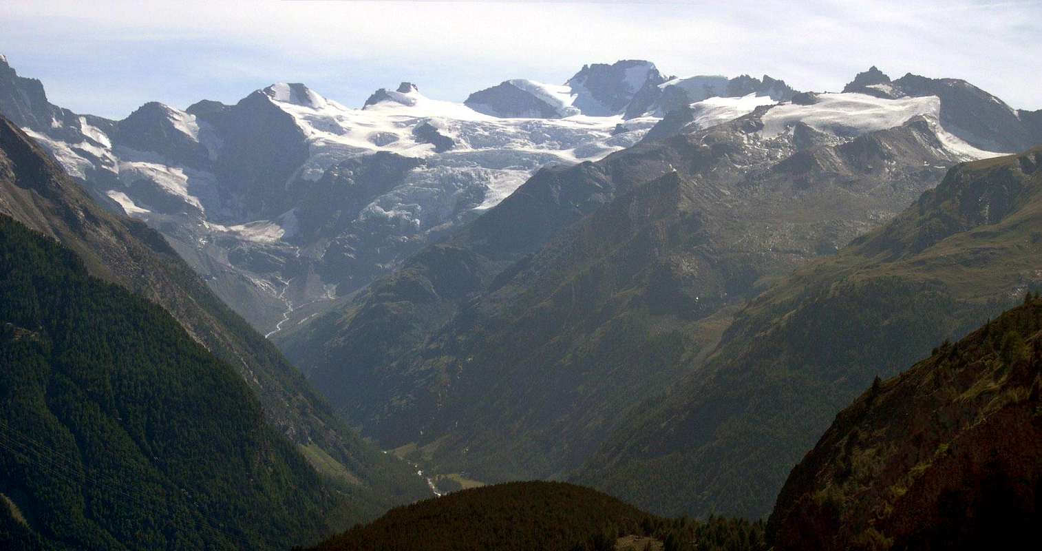
Gran Paradiso GROUP: Head of Valnontey seen from Vallone di Grauson


Further general information concerning Gran Paradiso GROUP can be obtained in the following pages:

Gran Paradiso Group - Northern Sector
Gran Paradiso Group - WE Main Ridge
Gran Paradiso Group - Southern Sector
Gran Paradiso GROUP - Features

What's New

  • Nov 19th, 2004: Added new photos and posted a first list of summits of a ridge
  • Nov 22th, 2004: Filled the sections of the ridges; something still to adjust. In particular the tables tentatively used to describe the ridge Valsavarenche - Valle di Cogne
  • Nov 30th, 2004: Added other photos and tables to be completed with thumbnails and further comments
  • Dec 14th, 2004: Added a table with refuges and bivouacs
  • Dec 20th, 2004: Added all the tables of the West East Ridge, at the moment without thumbnails
  • Jan 03th, 2005: Continued to add thumbnails to the tables
  • Jan 07th, 2005: Reordered the tables, shifted some thumbnails in the third column, added some photos in the table headings
  • Jan 16th, 2005: Added 20years-old images of the glaciers, compared with the present state
  • Jan 26th, 2005: Added the 200th photo: many of them have been used in the tables to identify summits, passes and the main features of the ridges
  • Feb 01th, 2005: Lost five tables because of a connection problem during the saving after an editing of the page; then the initial situation has been restored
  • Feb 15th, 2005: Added an interactive table of contents at the beginning of the page: in such a way it is possible to go directly to the section of interest
  • Feb 17th, 2005: unfortunately I realized only now that html commands don't work in the same manner using Opera as browser: can anybody mail me in the case of problems with other browsers? Thanks!
  • Feb 23th, 2005: made some minor corrections so that the page works in a acceptable way also with Opera7
  • Mar 01th, 2005: thanks to a team game, attached all the "stamps" to the table regarding the Val di Rhêmes head
  • Mar 22th, 2005: provided by many fonts lacking images of some bivouacs; inserted also an overranged image at the beginning of the Overview section
  • Jul 08th, 2005: during the last months, I added further sections, both concerning lakes, waterfalls and, at the end of the page, sections containing the photos of the many contributors
  • Sep 20th, 2005: added the links to the pages of other single summits belonging to the Group and some informative photos of the southern sector
  • Feb 06th, 2006: in occasion of the migration to SPv2 splitted the page in subgroups to make easier the access for every SPer
  • Jun 05th, 2006: updated the map showing location, name and height of the summits posted on SP.


Present Status of Posting on SP of the Gran Paradiso GROUP Summits


Partial interactive list, in chronologic order according to the submission date, of the summits belonging to the Gran Paradiso Group posted on SP

A) Gran Paradiso (4.061m)
B) la Grivola (3.969m)
C) Tresenta (3.609m)
D) Gran Serra (3.552m)
E) Ciarforon (3.642m)
F) Punta Rossa della Grivola (3.630m)
G) Becca di Moncorvè (3.875m)
H) Becco Meridionale della Tribolazione (3.360m)
I) Becca di Montandayné (3.838m)
J) Bioula, Punta di (3.414m)
K) Roccia Viva (3.650m)
L) Taou Blanc, Mont (3.438m)
M) Mont Paillasse (2.414m)
N) Torre del Gran San Pietro (3.692m)
O) Herbetet, Punta (3.778m)
P) Becca di Monciair (3.544m)
Q) Torre di Sant'Orso (3.618m)
R) Testa di Entrelor (2.580m)
S) Punta di Ceresole (3.777m)
T) Cresta Gastaldi (3.894m)
U) Becca di Gay (3.621m)
V) Torre di Lavina (3.308m)
W) Punta Basei (3.338m)
X) Il Roc (4.026m)


Moving SLOWLY the pointer of your mouse over each labelled summit, its name and height are shown.
Clicking on it, you will go the SP related page

A= Gran Paradiso (4.061m) B= la Grivola (3.969m) C= la Tresenta (3.609m) D= Gran Serra (3.552m) E= Ciarforon (3.642m) F= Punta Rossa della Grivola (3.630m) G= Becca di Moncorvè (3.875m) H= Becco Meridionale della Tribolazione (3.360m) I= Becca di Montandaynè (3.838m) J= Bioula, Punta di (3.414m) K= Roccia Viva (3.650m) L= Taou Blanc, Mont (3.438m) M= Mont Paillasse (2.414m) N= Torre del Gran San Pietro (3.692m) O= Herbetet (3.778m) P= Becca di Monciair (3.544m) Q= Torre di Sant'Orso (3.618m) R= Testa di Entrelor (2.580m) S= Punta di Ceresole (3.777m) T= Cresta Gastaldi (3.894m) U= Becca di Gay (3.621m) V= Torre di Lavina (3.308m) W= Punta Basei (3.338m) Interactive map showing location, name and height of the summits posted on SP.


Overview


Moving the cursor you can see the overall view

West side of the main Gran Paradiso range, starting from La Grivola, on the left, including Gran Serz, Herbetet, Becca di Montandaynè, Piccolo Paradiso, Gran Paradiso, Becca di Moncorvè, Tresenta, Ciarforon, Becca di Monciair and ending with Denti del Broglio, on the right. Also Punta Fourà, Taou Blanc in the foreground (and Levanne in the background) are recognizable. (photo by besucher01)


The Gran Paradiso group includes the only 4.000 meter summit entirely in Italian territory, that is the namesake summit that reaches 4.061 meters. According to an unlikely theory, also la Grivola (sung by the Italian poet Giosuè Carducci, winner of the 1906 Nobel prize for literature) formerly touched the height of 4.000m, before shrinking to the present 3.969 meters, due to a collapse of its summit spire.
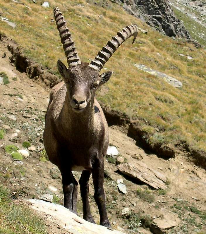
Gran Paradiso is one of the most important groups of the Western Alps; in particular it belongs to Alpi Graie (Graian Alps). Its western and eastern boundaries are not exactly identified: the geological limits are generally placed W at Col del Nivolet (2.612m) and E at Col dell'Arietta (2.939m), whereas the debated geographical limits are placed W at Col di Rhemes or Punta Basei (3.338m), E at Rosa dei Banchi (3.164m) or Bec Pragelas (2.908m). In the latter case, the borders coincide with the ones of Parco Nazionale del Gran Paradiso, the first Italian National Park instituted in the year 1922, approximately on the area that had been the Royal Hunting Preserve. King Vittorio Emanuele II had wanted the hunting preserve, in order to prevent the extinction of steinbock (Capra ibex) and chamois (Rupicapra rupicapra), of which he was an inveterate hunter.
photo_id=119208
Handmade map of the Gran Paradiso National Park. In red the limits of the Park, in black the border between the northern sector (Valle d'Aosta) and the southern one (Piemonte)
Both group and park extend over Valle d'Aosta and Piemonte, whose border is just the ridge, belonging to the Gran Paradiso group and running from west to east. In Valle d'Aosta, a series of ranges developing in the south-north direction separates the different valleys; from the west the three principal valleys: val di Rhemes, Valsavarenche and valle di Cogne, which in turn originates Valnontey (that is the heart of the Group), Valeille, and the secondary valleys of Bardoney and Acque Rosse.
In the Piemontese sector, starting from Valle dell'Orco, the main valley of Ceresole Reale that runs from east to west, a series of secondary valleys originates, directed approximately northwards: the "valloni" of Soana, Campiglia, Forzo, Eugio, Piantonetto, Noaschetta, Gias della Losa, Goi, Ciamousseretto, Roc, all divided by ridges less imposing than the ones in the Valle d'Aosta sector.
Valle dell'Orco played a fairly important role in the history of rock climbing in Italy in the 1970s. Besides, in the Vallone del Piantonetto one can find fantastic gneiss on the Becco di Valsoera, Becco della Tribolazione and many other local summits, drops up to 700 m and all kinds of difficulties.
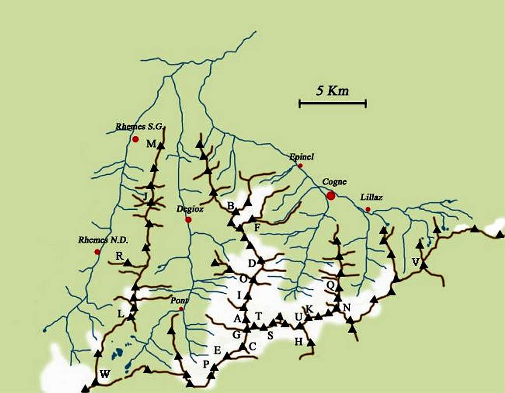
Gran Paradiso GROUP  photo_id=128479 Gran Paradiso GROUP  photo_id=130668 Gran Paradiso GROUP  photo_id=132285 Gran Paradiso GROUP  photo_id=133501 Gran Paradiso GROUP  photo_id=124682
Gran Paradiso GROUP  photo_id=130662 Gran Paradiso GROUP  photo_id=132284 Gran Paradiso GROUP  photo_id=134573 Gran Paradiso GROUP  photo_id=132286 Gran Paradiso GROUP  photo_id=133714

Getting There


Valle di Cogne
  • From Torino, Milano, etc: motorway A5. Exit at Aosta Ovest. Drive to the near Aymavilles. Follow the directions for Valle di Cogne.
  • From Switzerland: through the Grand Saint Bernard Tunnel or the namesake Pass. Drive to Aosta, then follow the direction for Courmayeur on SS.26. Just after Sarre, turn to the left, in the direction of Valle di Cogne.
  • From France: through Mont Blanc Tunnel or Petit St. Bernard Pass. It isn't necessary to take Motorway A5: you can drive on SS.26, in the direction of Aosta. Before arriving at the village of Sarre, turn right following the sign for Valle di Cogne.
After Aymavilles, the Regional Road n° 47 crosses the villages of Vieyes, Epinel and Cretaz and after about 25 Km arrives at Cogne (1.534m). From Cogne you can get the villages of Lillaz (1.617m) or Valnontey (1.666m).
Val di Rhêmes and Valsavarenche
  • From France, through the Mont Blanc Tunnel or the Col du Petit Saint Bernard: you can drive on SS.26, following the direction for Aosta and, before arriving in Villeneuve, turn right towards Introd. Alternatively, you can take motorway A5 (at Courmayeur or Morgex) and exit at Aosta Ovest.
  • From all other directions: get to the Aosta Ovest exit of motorway A5. Then drive along SS.26 Aosta, direction Courmayeur, and just after Villeneuve turn left towards Introd.
Shortly after Introd, you arrive at a junction:
  • you can go straight following the sign "Val di Rhêmes"and then drive through Rhêmes Saint Georges as far as Rhêmes Notre Dames; after the main village, Bruil (1.723m), the road reaches the hamlet of Pellaud, then becomes narrower and may be followed as far as the vast parking in view of Thumel (1.880m). From here the road follows but the transit is forbidden.
  • or you can turn left, entering in Valsavarenche, and after many villages (Degioz, Eaux Rousses, etc) you will arrive at Pont (1.978m) where the road ends.
Southern valleys of the Gran Paradiso Group
  • Coming from Torino: motorway A5 towards Aosta - take exit "S. Giorgio Canavese" or follow the road SS n°460 towards Ceresole Reale as far as Pont Canavese (461m)
  • Going North along Val Soana, after Ronco Canavese (956m) get to Valprato Soana (1.113m): at a fork, going NE takes you to Campiglia Soana (1.350m), while going NW takes you to the upper valley (Pianetto-Pamprato)
  • Before Pont Canavese, turn left and go into the Valle di Forzo as far as the homonymous village (1.180m )
  • after Pont Canavese, continue along the SS n° 460 until Locana (613m): from here you can walk, entering Valle d'Eugio.
  • After Locana, when you arrive at the village of Rosone (715m), 16 km after Pont Canavese, take a small road on the right, following the sign "Piantonetto Valley": the road ends near Teleccio Lake (1.870m).
  • Following along the Valle dell'Orco, 10 km after Rosone you get to Noasca (1.062m): from here you can reach the Noaschetta valley that, after Alpe la Bruna (2.473m), divides into Vallone di Goi and Vallone del Gias della Luna, or Vallone di Ciamousseretto, where you can arrive more laboriously from the following Vallone del Roc.
  • After Noasca, the road climbs along a gorge (Caporal and Sergent walls) and then arrives at the upper wide basin where, on the shore of an artificial lake, you meet Ceresole Reale (1.613m), 33 km after Pont Canavese. From Ceresole starts a controversial road that enter Gran Paradiso National Park and, after Serrù Lake and Agnel Lake, climbs up to Colle del Nivolet (2.612m). Luckily the original absurd project to continue the road on the other side, in order to connect with Pont (Valsavarenche) through the Piani del Nivolet, was stopped in time.


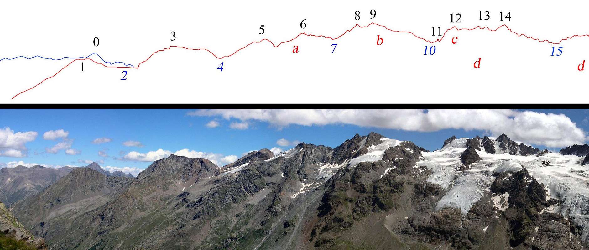
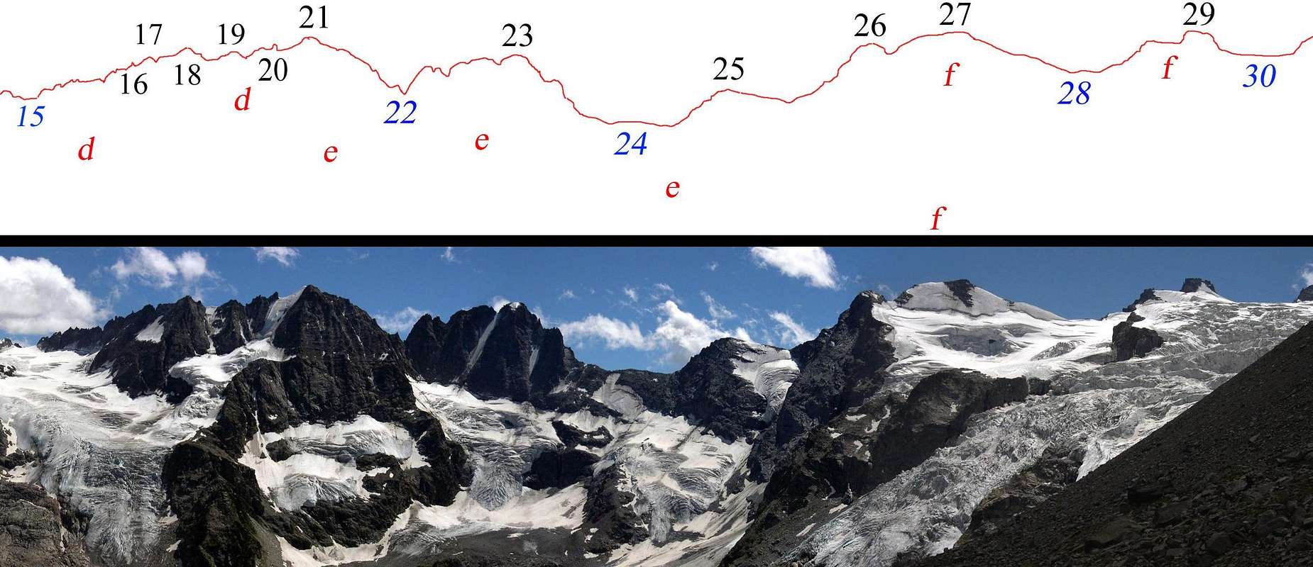
Pano with annotated summits


Identification of summits, passes and glaciers belonging to the watershed Valnontey-Valeille.
In the far background, on the left, Punta Tersiva (view from Bivacco Leonessa 2910m)

Profile of the Watershed Valnontey -Valeille
  SUMMITS and   PASSES
GLACIERS
  0 – Punta Tersiva 3513 m

 aGhiacciaio di Valletta

  1 – Punta Fenilia 3053 m  b -  Ghiacciaio di Patrì
  2 – Colle della Granzetta 2933 m  c - Ghiacciaio del Coupè di Money
  3 – Punta di Valmiana 3244 m  d Ghiacciaio di Money
  4 – Colle di Valmiana 3093 m  
  5 – Punta Valletta N. 3318 m / S. 3356 m
  6 – Punta Tsissetta 3419 m
  7 – Colle Patrì 3361 m
  8 – Punta Patrì N. 3561 m
  9 – Punta Patrì S. 3581 m
10 – Colle Coupè di Money 3393 m
11 – Dito degli Apostoli 3439 m
12 – Torre di S. Orso 3618 m
13 – Torre di S. Andrea 3651 m
14 – Torre del Gran San Pietro 3692 m
15 – Colle di Money 3443 m


Identification of summits, passes and glaciers belonging to part of the watershed Valnontey-Valle dell'Orco.
View from Lucio and Lionello Leonessa fixed bivouac 2910m
</div
Profile of the head of VALNONTEY
SUMMITS and PASSES
GLACIERS
15 - Colle di Money 3443m d - Ghiacciaio di Money
16 - Campanile di Money 3540m e - Ghiacciaio del Gran Crou
17 - Testa di Money 3572m f - Ghiacciaio della Tribolazione
18 - Becco della Pazienza 3606m  
19 - Punta Elter 3603m  
20 - I Gemelli 3610m / 3618m  
21 - Roccia Viva 3650m  
22 - Colle Baretti 3432m  
23 - Becca di Gay 3621m  
24 - Colle di Gran Crou 3315m  
25 - Gran Crou 3437m  
26 - Testa di Valnontey 3562m  
27 - Testa della Tribolazione 3642m  
28 - Colle della Luna 3542m  
29 - Punta di Ceresole 3777m  
30 - Colle Chamonin 3698m  


Southern side of Gran Paradiso Range seen from La Cialma 2.193m
 SUMMITS  PASSES
1 - Ciarforon 3.642m 1 - Colle del Ciarforon 3.317m
2 – Tresenta 3.609m 2 - Colle di Moncorvè 3.294m
3 - Becca di Moncorvè 3.875m 3 - Colle del Gran Paradiso 3.345m
4 - Gran Paradiso 4.061m 4 - Colle della Becca di Moncorvè 3.851m
5 - Cresta Gastaldi 3.894m 5 - Colle dell’Ape (Col de l’Abeille) 3.873m
6- Punta di Ceresole 3.777m 6 - Colle Chamonin 3.698m
7 – Testa della Tribolazione 3.642m 7 - Colle della Luna 3.542m
8 - Testa di Valnontey 3.562m 8 - Colle Baretti 3.432m
9 - Becca di Gay 3.621m  
10 - Roccia Viva 3.650m  
11 - I Gemelli 3.610/3.618m  
12 - Punta Elter 3.603m  
13 - Becco della Pazienza 3.606m  


Panoramic view of Gran Paradiso Group from South (Monte Soglio): moving the cursor you can see the overall view

When to Climb

During the summer, usually; during the other seasons one must evaluate the characteristics of the destination summit.

Red Tape

Within the borders of the P.N.G.P. (Parco Nazionale del Gran Paradiso), at the moment (summer 2005), dogs generally are not allowed, except on a pair of trails, and camping is forbidden (except above 2.500m from sunset till dawn).No fees are due.

Mountain Conditions

You can get meteo information at the official site of the Regione Valle d'AostaValle d'Aosta Meteo Weather forecasting concerning both Piemonte and Valle d'Aosta can be found at nimbus.it

Camping

There are plenty of camping sites along the Gran Paradiso valleys. Remember that free camping is forbidden (except for emergency reasons, over 2.500 m, from darkness until dawn).


Books and Maps


BOOKS
  • E. Andreis, R. Chabod, M.C. Santis "Guida dei Monti d'Italia - Gran Paradiso Parco Nazionale" Club Alpino Italiano / Touring Club Italiano, 1980 (in Italian)
  • L. Zavatta Le valli del Gran Paradiso e la Valgrisenche, guide dell'Escursionista, 2003 (in Italian)
  • Giulio Berruto "Il Parco Nazionale del Gran Paradiso (Valli Soana-Orco-Rhêmes-Valgrisenche)” N°3/volume 1°, IGC, Torino 1981, 2a edizione 2000. (in Italian)
  • Giulio Berruto "Il Parco Nazionale del Gran Paradiso (Valli di Champorcher-Clavalitè-Saint Marcel-Laures-Cogne-Valsavarenche-Conca di Pila)” N°3/volume 2°, IGC, Torino 1981, 2a edizione 2000. (in Italian)
  • M. Oviglia Rock Paradise Arrampicate classiche, moderne e sportive nelle valli del Gran Paradiso, Collana Luoghi Verticali, Edizioni Versante Sud, 2000 (in italian) suggested by Gasgenova
  • A. Gogna, G. P. Motti, "Escursioni ed arrampicate nel Canavese",Tamari Editori (in Italian) suggested by Brenta

MAPS
  • KompassGran Paradiso Valle d'AostaSentieri e rifugi-Carta turistica 1:50000
  • IGC-Istituto Geografico CentraleValsavarenche Val di Rhêmes ValgrisencheCarta dei sentieri e dei rifugi 1:25000
  • IGC-Istituto Geografico CentraleGran Paradiso La Grivola CogneCarta 1:25000
  • I.G.M. -Istituto Geografico MilitareFoglio 41 1:25000I NO La Grivola - I SO Gran Paradiso - I NE Cogne - I SE Torre del Gran San Pietro - II NO Fornolosa - II NE Ceresole Reale - III NE Colle del Nivolet - IV NE Rhêmes Saint George - IV SE Rhêmes Notre Dame
Gran Paradiso GROUP  photo_id=124681 Gran Paradiso GROUP  photo_id=124776 Gran Paradiso GROUP  photo_id=124777

Acknowledgements

Many thanks are due to all the friends who supported me in different ways. Besides Maria Grazia, Beppe, Gabriele, Paolo, Sergio, Diego, Mathias and Marco, my thanks go in particular to:
  • Antonio for all his "stamps" used to illustrate the tables of the watersheds
  • Fabio for the supervision of my otherwise shaky English language
  • Gangolf for his continuous and precious suggestions

Miscellaneous Info

If you have information about this mountain that doesn't pertain to any of the other sections, please add it here.

Important Information

Useful Numbers

  • Soccorso Alpino Cogne (SAR) Tel. 3482685406.
  • Protezione Civile Valdostana località aeroporto 7/A Saint Christophe (Ao) Tel. 0165-238222.
  • Bollettino Meteo (weather info) Tel. 0165-44113.
  • Unità Operativa di Soccorso Sanitario Tel. 118.

External Links


Children

Children

Children refers to the set of objects that logically fall under a given object. For example, the Aconcagua mountain page is a child of the 'Aconcagua Group' and the 'Seven Summits.' The Aconcagua mountain itself has many routes, photos, and trip reports as children.