
-
 8443 Hits
-
 86.85% Score
-
 23 Votes
|
|
Mountain/Rock |
|---|---|
|
|
45.63510°N / 7.55774°E |
|
|
Mountaineering |
|
|
9403 ft / 2866 m |
|
|
Overview
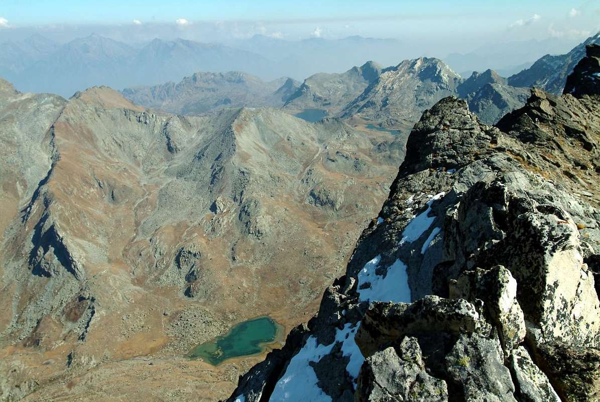
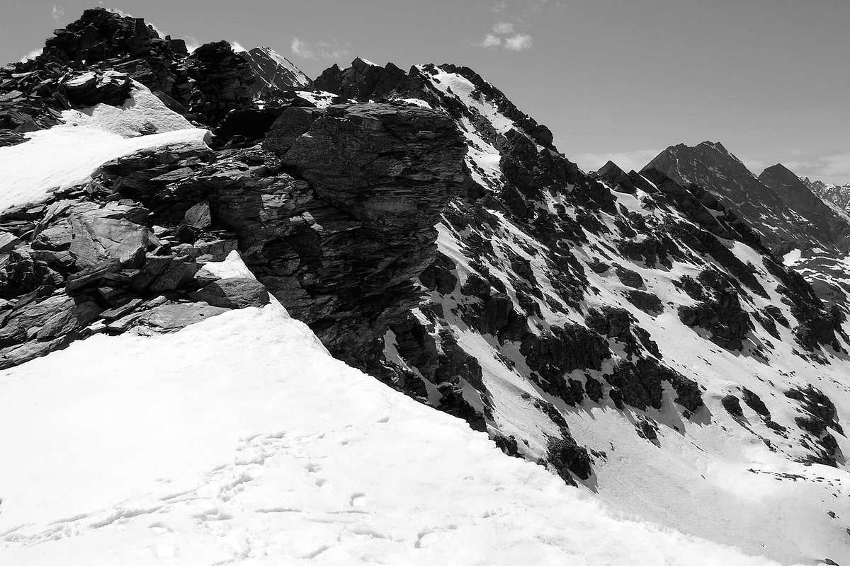
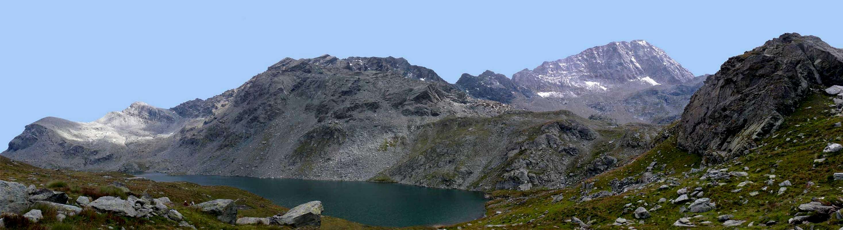
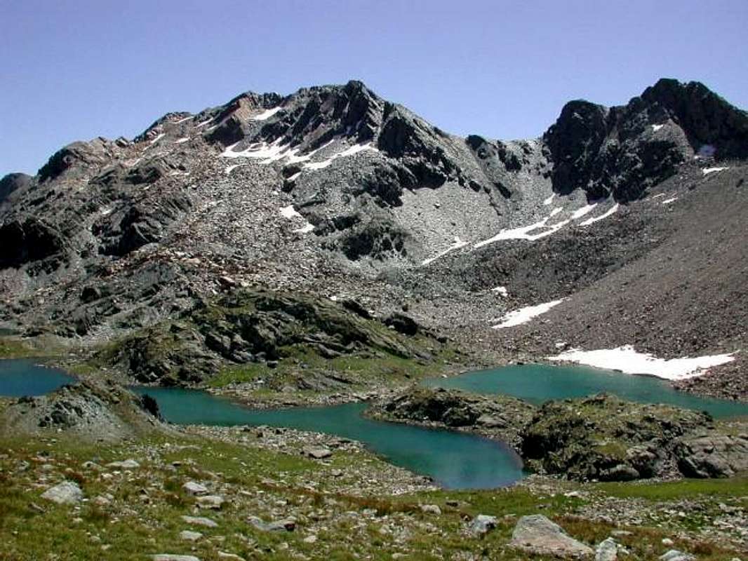
Mountain of the particular shape and prepared on the axle Ovest/Est along the crest watershed among the Mont Glacier (3.186m) and the Bocon Damon or Quota 2.792 meters, fit to separate the Valleys of Champorcher to South and of Champdepraz or "of the Lakes" to North and entirely inside the Natural Park of the Mont Avic (3.006m). It acts from great enlarged slope, inclusive among the two homonyms of his East (2.766m) and West (2.786m) Western Necks and the Pisonet Hill 2.734m in East on the long crest that goes down then toward the Tête des Hommes (2.614m), Torretta (2.539m) and Passes of the Lago Bianco (2.308m) and della Croce (of the Cross; (2.298m), impending the Gran Lago (2.500m), the greatest of the whole Valley of Aosta. Introduces three crests and three slopes: the West-southwest Crest that exactly, after being come down to the two homonym passes, it goes up again to the Mount Glacier, greater peak of the whole small subgroup; always on the watershed the Crest East-northeast that descends gradually to the small foretold hill also called of Pisonet, while toward South a longer such ridge-buttress goes down to separate, inside the Valley of Champorcher, the two Walloons of the West Giasset and of the East Raty, with theirs two homonym lakes. The faces in reality are two of which one turned to North toward the Gran Lake and the other to South in two direction small "valloni" of which above; really, the last quoted crest divides this last in two faces, of which the first, revolt to South-southwest, introduces a wall of enough good rock, even if of modest height, long which an interesting itinerary of climb has been traced. The second, turns Southeast, it is composed from rocks mostly routs and you shatter alternate to small rocky channels or snowy slopes and it doesn't denote particular interest for the climb. Atypical top to form of pyramid cut and flat and lengthened, introduces two Antesummits contrasted to East and to West; more interesting this last, since in case of great and dangerous frames in the final line that separates from the great little fellow in stone or, and better, the great stony cairn of the maximum Top, he can constitute point of arrival of the whole trip, or as such we recommend it. It doesn't result to have been climbed in winter and however it is trip that a lot of excursions are lent good of ski-mountaineering and also in snow rackets or snowshoes, in cause of good snow presence; with the beautiful season you can be considered trip of training, such to also allow some small climb wanting to look for the particular passages along and through its ridges or its rocky faces. From his Peak the sight spaces to North and East on the GROUP of the Mont Avic/Ruvic (2.922m) and in hemicircular distance on all the Pennine Alps, while to West it is limited from the mass of the Mounts Delà (3.139m)/Glacier; toward South beautiful sight on the Rosa dei Banchi in the Southeastern Graian Alps and to the beginning of the Chain of the Gran Paradiso (from Lavina Tower, Arolla Group, Gran San Pietro with Apostles up to the Summit), that is unfolded in the shape of radial arrangement toward Southwest. Notable, besides, the sight on all the lakes that surround it around three sides to her exposed; in fact, except the turned side to East toward the Bocon Damon or Quota 2.792 meters, a widens team of lakes and small lochs it ogles to his slopes, both on the slope of Champdepraz and on the opposite one of Champorcher, delineating to form of breadth fan a whole series of colors that they go from the greyish green to the deep blue, according to the surrounding rocky composition, surely very ancient.
 |
Montagna atipica e di forma particolare nonché disposta sull'asse Ovest/Est lungo la frastagliata cresta spartiacque tra il Mont Glacier (3.186 m) ed il Bocon Damon o Quota 2.792 m, atta a separare le Valli di Champorcher a Meridione e di Champdepraz o "dei Laghi" a Settentrione ed interamente all'interno del Parco Naturale del Monte Avic (3.006 m). Funge da grande spalto allungato, compreso tra i due suoi omonimi Colli Est (2.766 m) ed Ovest (2.786 m) ad Occidente ed il Colle Pisonet 2.734 metri ad Oriente sulla lunga cresta discendente in seguito verso la Tête des Hommes (2.614 m), la Torretta ed i Colli del Lago Bianco (2.308 m) e della Croce (2.298 m), soprastante il Gran Lago (2.500 m), il più grande dell'intera Valle d'Aosta. Presenta tre creste e tre versanti: la Cresta Ovest-sudovest che appunto, dopo essere "calata" ai due omonimi colli, risale al Mont Glacier, vetta maggiore dell'intero piccolo sottogruppo; sempre sullo spartiacque la Cresta E-NE che digrada al piccolo colle predetto o del Pisonet, mentre verso Meridione scende una più lunga cresta-contrafforte, tale da separare, all'interno della Valle di Champorcher, i due Valloni del Giasset ad Ovest e del Raty ad Est con i loro due omonimi laghi. I versanti, in realtà, sono due dei quali uno rivolto a Nord verso il Gran Lago e l'altro a Sud in direzione dei due piccoli valloni di cui sopra; proprio l'ultima cresta-contrafforte citata divide questo ultimo in due facce, delle quali la prima, rivolta a Sud-sudovest, presenta una parete di roccia abbastanza buona, anche se di modesta altezza, lungo la quale è stato tracciato un itinerario interessante di arrampicata. La seconda, rivolta a Sudest, è composta da rocce maggiormente rotte e frantumate alternate a canaletti rocciosi o pendii innevati non denotando particolare interesse per l'arrampicata. Cima atipica a forma di piramide monca ed allungata, presenta due Antecime contrapposte ad Oriente ed ad Occidente; più interessante questa ultima, poiché in caso di grandi e pericolose cornici nel tratto finale, che separa dal grande ometto in pietra della Cima massima, può costituire punto di arrivo dell'intera gita, o come tale lo consigliamo. Non risulta esser mai stata salita in inverno e, comunque, è gita che si presta molto bene ad escursioni di sci-alpinismo ed anche in racchette da neve, con un buon innevamento e relativa preparazione; con la bella stagione può esser considerate gita d'allenamento, tale da acconsentire anche qualche breve arrampicata, volendo ricercarne i passaggi un pò particolari da scovare lungo ed attraverso le sue creste od i suoi versanti rocciosi, peraltro non sempre troppo solidi. Dalla sua Vetta la vista spazia a Settentrione ed a Oriente sul Gruppo del Monte Avic/Ruvic (2.922 m) ed in lontananza semicircolarmente su tutte le Alpi Pennine, mentre ad Ovest è limitata dalle masse dei Mont Delà (3.139 m) e Glacier; verso Sud bella vista sulla Rosa dei Banchi nelle Alpi Graie Sudorientali ed all'inizio della Catena del Gran Paradiso, che si dispiega a raggiera verso Sudovest. Notevole, inoltre, la vista su tutti i laghi che la circondano sui tre lati a lei esposti; infatti, tranne il lato rivolto ad Oriente verso il Bocon Damon o Quota 2.792 metri, un'amplia schiera di laghi e laghetti occhieggia alle sue pendici, sia sul versante di Champdepraz che sull'opposto di Champorcher, delineando a guisa di largo ventaglio tutta una serie di sfumature con colori dal verde grigiastro al blù profondo, a seconda della composizione rocciosa circostante di certo alquanto antica.
 |
First Ascents
- First on the Summit: Unknown.
- In Winter: Unknown or Diego Gaioni, Sandro Dallou and Fabrizio Lateltin, Jan 19th, 2002. through S Wall? (see under).
- Integral crossing of S Spur, from three Becs Raty (2.382m, 2.399m, 2.417m)-Giasset Pass, Quota, 2.504m, 2.502m-East Antesummit-Gran Rossa and traverse to Pisonet Pass and Bocon Damon: Emilio Bertona, Osvaldo Cardellina, Nicola Colajanni and Gianfranco Vicentini, Aug 13th, 2002, in day from Royal Road.
- S Wall Central Spur of the West Antesummit: Diego Gaioni, solo, May 23th, 1999.
- First in Winter S Wall Central E'peron of the West Antesummit: Diego Gaioni, Sandro Dallou and Fabrizio Lateltin, Jan 19th, 2002.
- N-NW Spur (to Western Leità Loch): Osvaldo Cardellina, lone, Nov 25th, 2007, in descent.
- N-NE Face (directly from Gran Lago): Osvaldo Cardellina, lone, Nov 25th, 2007, in ascent.
- North Edge (to Eastern Antesummit and traverse): Osvaldo Cardellina, lone, Nov 25th, 2007, in ascent.
- Integral Traverse from Medzove Pass: Quota 2.848m of M. Glacier-Quotas 3.110m, 3.003m, 2.917m, Gr. Rossa W and E Passes, Antesummit West 2.860m around, Gr. Rossa-Quotas 2.804m, 2.734m, 2.792m, 2.746m, 2.708m and descent, by North Slope, to Great Lake: Osvaldo Cardellina, lone, Aug 28th, 1975, in day from Petit Mont Blanc.
 |
Getting There
BY CAR:- From Torino, Milano, etc: Motorway A5. Exit Pont Saint Martin for then to continue on SS.26 toward Hone Bard.
- From Switzerland: through the Grand Saint Bernard Tunnel or the namesake pass. Drive to Aosta, Fénis Village or Verrès and Hone Bard.
- From France: through Mont Blanc Tunnel or Petit Saint Bernard Pass. It isn't necessary to take Motorway A5: you can drive on SS.26, in the direction of Aosta and Fénis Village or Verrès and Hone Bard.
- Aeroporto "Corrado Gex" Saint Christophe (Aosta).
Approaches of base
A) - Through the Dondena Royal Road (Champorcher) From the exit of Motorway to Pont Saint Martin reach, through a Main Road, Donnas Commune: immediately after the village (interesting view on the adjoining road to console adorned by a beautiful Roman arc). Some hundred meters, to the of near of I approach Dora Baltea Stream, bridge of the to cross they govern the indication Champorcher; to follow the Regional Road for this place. Of to go beyond the of Commune Pont Bozet the to reach the Village-Chief town called "Le Château" (The Castle; immediately is found the indication to Fraction Petit Mont Blanc. Road of this to follow, not too much great, for different km; the first part of the same one is in asphalt for then to continue in beaten earth. Usually the conditions of this second are enough good and however it are worthwhile to ask for information in the zone, considering that lately works of government maintenance are performed. Road of this to continue, the ancient one of they govern of coincident Real Road by the Italy King Vittorio Emanuele II° in '800, octave flute than to the of until and underlying the Dondena little Village, near the Torrent Ayasse (2.100 meters; at the end a signal it prevents the traffic, immediately in the narrow as well as limited parking lot; poster signallers in cover of bench of an in wood; great crowd confusion of relative of and; a feet 1h'30/2h'00 from the term of the asphalted road).A) - Dalla Strada Reale di Dondena (Champorcher) Dall'uscita dell'autostrada in Pont San Martin raggiungerre Donnas: immediatamente dopo il villaggio (interessante veduta sull'attigua strada consolare ornata da un bel arco romano. Alcune centinaia di metri, appresso vicino alla Dora Baltea, attraversare il ponte con l'indicazione Champorcher; seguire la strada regionale per questa località. Oltrepassare il Comune di Pont Bozet e raggiungere il Villaggio del Capoluogo di Chateau; subito a monte della strada si trova l'indicazione per la Frazione del Petit Mont Blanc. Seguire questa strada, non troppo grande, per diversi km; la prima parte della stessa è in asfalto per poi proseguire in terra battuta. Di solito le condizioni di questa seconda sono abbastanza buone e comunque conviene richiedere informazioni in zona, visto che ultimamente sono state eseguite opere di manutenzione. Seguire questa strada, coincidente con l'Antica Strada Reale, fino al piccolo e sottostante Villaggio di Dondena, presso il Torrente Ayasse (2.100 m; al termine un segnale impedisce il traffico, subito dopo il ristretto nonché limitato parcheggio; cartelli segnalatori in una panchina coperta in legno; grande folla e relativa confusione; a piedi 1h'30/2h'00 dal termine dell'asfalto).
 |
 |
 |
 |
 |
B) - Through the Lakes Vallon (Upper Champdepraz Valley) From the small Village of La Cort, to continue verse West-northwest on the Real Road in earth for Dondena Village reaching not very after a small parking lot near and along the same one (1.830/40m around; noumerous signalings and entry "official" in the Park of the Avic Mountain). To begin awry immediately with the path n° 10 that part (North) and it goes up again with a steep zigzag bringing itself, with direction Northeast, at first toward a small secondary torrent and subsequently placing side by side that more important descendant from the impending Loch Muffé. To go up again along the bank right hydrographic of the same one with the path-muletrack, that unties him with a series of hairpin bends flanking the wood, alternate to rectilinear lines in diagonal. To go out, leaving on the right (East) the deviation for the "Alpage" of La Grand Cort (1.944m, that from he is quietly seen here "abandoned" among green pastures) so in the superior plateau in her "wide narrow passage" among the appendixes of the Mont Ros (2.289m) to West and you it terminal of the Southwest Crest that it climbs to the Top Perche (2.396m; also with the toponym of Perché, or Perforated), or Southern shoulder of the Cima Piana (Plain Top also called, for the Issogne Commune inhabitants, Mont de Panaz 2.512m). Continue on the walloon floor through less steep slope with run mostly "open" and, abandoning on the left (West) the deviations for the Lake Vernouille (2.145m) with the paths n° 9C/10B and, momentarily, also the n° 10, to climb with the n° 10C reaching the ruin of the old Alp Muffé (2.076m), close to the homonym Lake suffered just neighbor to the East (2.119m; 0h'30). From this to ascend up with direction Northwest in a zone even more disclosed among small backs with lawns and moraines (small sources that gush out a little everywhere) again meeting the path "of base" n° 10, that it originates "of return" from the Vernouille Loch, few more than hundred meters more aloft. To go therefore the aforesaid variation goes with, that continues in opposite direction (Northeast) toward the nearby Lago Bianco Hill (White Loch; 2.308m), and to proceed with this last I pour the neighbour Col de la Croix (Hill of the Cross; 2.287m), reaching it with a final line, always through a good path of a little steep (E; 1h'15/1h'30). A short descent leads quickly and comfortably to the Refuge Barbustel (2.209m), located between Bianco and Vallette Lochs (2.132m, 2.170m; 0h'15). From this go up into wild and spledid Walloon of the Lakes on the Upper Valley Champdepraz and, with the trail n° 6/102, passing in succession the Lake Bianco (2.132m) via a short descent, Nero (2.166m) and Cornuto (2.168m), passing just above their banks and reaching to the North Pisonet Alpage (2.301m), located on pleasant basin at the end of this first part of the walloon and below a rocky promontory with gorge. From this path, which gradually turns into beautiful muletrack, turned decidedly from the West to the South and the steep back with a dozen hairpin bends standing at Grand Lake (2.485m; 1h'45/2h'00). The same is the largest in Aosta Valley and at the beginning of the second and upper part of the walloon. Flanking its Northern shore is reached at a small waterfall, and its tributary immediately below the Bivouac Verthuy of the Forest (2.535m; private and closed), amid a swarm of small lakes called of Leità (E; 1h'30/2h'00 from the Barbustel Shelter).
B) - Tramite il Vallone dei Laghi (Valle Superiore di Champdepraz) Dal piccolo Villaggio di La Cort, continuare verso Ovest-nordovest sulla sterrata della Strada Reale per Dondena raggiungendo non molto dopo un piccolo parcheggio in terra battuta presso e lungo la medesima (1.840/50 m~; nunerose segnalazioni ed ingresso "ufficiale" nel Parco del Monte Avic). Iniziare con il sentiero n° 10 che parte subito a monte (Nord) e risale con un ripido zig-zag portandosi, con direzione Nordest, dapprima verso un torrentello secondario e successivamente affiancando quello più importante, discendente dal soprastante Lac Muffé. Risalire lungo la sponda idrografica destra del medesimo con il sentiero-mulattiera, snodantesi con una serie di tornantini affiancando il bosco, alternati a tratti rettilinei in diagonale. Uscire, lasciando sulla destra (Est) la deviazione per l'Alpe La Grand Cort (1.944 m), che da qui si vede tranquillamente "adagiata" tra verdi pascoli così nell'altipiano superiore nella "larga strettoia" tra le appendici del Mont Ros (2.289 m) ad Occidente e la propaggini terminali della Cresta Sudovest che risale alla Cima Perche (2.396 m; anche con il toponimo di Perché, ovvero Forata), o spallone Sud della Cima Piana od anche, per gli abitanti del Comune di Issogne Mont de Panaz (2.512 m). Continuare sul fondovalle con percorso alquanto meno ripido e maggiormente dischiuso e, abbandonando sulla sinistra (Ovest) le deviazioni per il Lac Vernouille (2.145 m) con i sentieri n° 9C/10B nonché, momentaneamente, anche il n° 10, salire con il n° 10C raggiungendo il rudere dell'Alpe Muffé (2.076 m), accanto all'omonimo Lago, subito viciniore ad Est (2.119 m; 0h'30). Da questo proseguire con direzione Nordovest in una zona ancora più aperta tra piccoli dossi con prati e morene (sorgentelle sgorganti un pò ovunque) incontrando nuovamente il sentiero "di base" n° 10, che proviene "di ritorno" dal Lac Vernouille, poco più di un centinaio di metri più in alto. Continuare quindi tramite la variante seguita, che procede in opposta direzione (Nordest) verso il Col de la Croix (2.387 m), e risalire con quest'ultimo verso il Colle del Lago Bianco (2.308 m), raggiungendolo con un tratto finale sempre con buon sentiero, appena più ripido (E; 1h'15/1h'30). Una breve discesa conduce comodamente nonché rapidamente al Rifugio Barbustel di recente costruzione (2.209 m), sito a mezza strada tra il Lac Blanc ed il Lac Vallette (2.132 m, 2.170 m; 0h'15). Da questo risalire lo splendido e selvaggio Vallone dei Laghi, nell'Alta Valle di Champdepraz e, con il sentiero n° 6/102, sorpassare in successione i Laghi Bianco (2.132 m), tramite una breve discesa, Nero (2166 m) e Cornuto (2.168 m), transitando poco al di sopra delle loro sponde Settentrionali e raggiungendo l'Alpe Pisonet (2.301 m), posta in una bella spianata al termine di questa prima parte del vallone e sottostante ad un caratteristico promontorio roccioso. Da questa il medesimo, che progressivamente si trasforma in bella mulattiera, da Ovest volge decisamente dapprima a Sud e risale quindi nuovamente verso Occidente l'erta con una dozzina di stretti tornanti portandosi al Gran Lago (2.485 m; 1h'45/2h'00). Il medesimorisulta come il più esteso di tutta la Val d'Aosta ed all'inizio della seconda e superiore parte del vallone. Fiancheggiando la sua sponda Settentrionale si raggiunge, presso una cascatella (ottimo posto di ristoro), il suo immissario e subito appresso il Bivacco Verthuy della Forestale (2535 m; privato e chiuso), sito tra un nugolo di laghetti detti della Leità (E; 1h'30/2h'00 dal Barbustel).
 |
Routes
A) - Through the E-NE Crest from Valley of Raty and the small Pisonet Collar 2734m: From the Real Road/High route n° 2, after the rectilinear long coming from the Alp-Village La Cort (1.880m around), to reach a first alternative with the descriptive poster "Raty"; abandoned the Real Road, to continue first toward Northeast and then Northwest through the road in earth, here coincident with the path-mule-track n° 9C, that salt through the wood. To reach so the Alp Sapy (1.979m), where the in soil road "poderale" it has end; to continue with the same path, but more moved toward North (beautiful small fountain gushed out from the rock; splendid sights, little by little that it rises us, on the East Wall of the Great Shoulder of the Oriental Bec Raty), going beyond on the left (West) a short rocky band, at the base of Southerner Slope of Bec Barmasse. You enters therefore the impending and mostly level Vallon of the real Raty, crossing the homonym Torrent, really under the reddish and rocky Wall I Know about the Bec Barmasse (2.296m); forded few over another branch of the same stream, the Pasture it is reached Raty Dèsot (= Lower; 2.241m) and, I immediately approach, the intersection with the path coming from the Lago Vernouille (2.145m) and from the Alps Raty de Fort (2.229m) and Raty (2.274m). Immediately later, easily with the same, the beautiful Lake is reached to Raty (2.283m) with its vast banks, really proper to good person "siesta" gastronomy (1h'00); from the lake, revolved to the left (South) its Southern bank, with to half dozen of hairpin bends and an enough long diagonal toward West the is reached "Collar of the Giasset", from where it is crossed toward the small walloon understood among the two Southern buttresses of the Bocon Damon and the Gran Rossa. To go up again it long stony ground completely contemplating Pisonet's Pass to the impending among the two mountains; reached it, to easily follow the crest watershed or East and medium easy reddish plates on the Slope North to reach at first the Oriental Antesummit and immediately after the Peak (F+; 0h'30/0h'40 from the hill; 2h'30/3h'00 from the earth Real Road).A)- Per la Cresta E-NE dal Vallone del Raty ed il Colletto del Pisonet 2.734 m: Dalla Strada Reale/Alta Via n° 2, dopo il lungo rettilineo proveniente dall'Alpe La Cort (1880 m~), raggiungere un primo bivio con il cartello segnaletico "Raty"; abbandonata la Strada Reale, continuare prima verso Nordest e poi Nordovest tramite la strada in terra, qui coincidente con il sentiero-mulattiera n° 9C, che sale attraversando il bosco. Raggiungere così l'Alpe Sapy (1.979 m), dove la strada "poderale" ha fine. Proseguire con il medesimo sentiero, ma più spostati verso Nord (bella piccola fontana sgorgante dalla roccia; splendide viste, a poco a poco che ci si innalza, sulla Parete Est dello Spallone del Bec Raty Orientale e sulle Alpi Graie del Sudest stagliantisi dirimpetto), oltrepassando sulla sinistra (Ovest) una corta fascia rocciosa, alla base Meridionale del Bec Barmasse. Si entra dunque nel soprastante e maggiormente pianeggiante Vallone del Raty vero e proprio, attraversando l'omonimo Torrent, proprio sotto la rossiccia e rocciosa Parete Sudovest del Bec Barmasse (2.296 m); guadato poco oltre un altro ramo dello stesso torrente, si raggiunge l'Alpe Raty Dèsot (2.241 m) e, subito appresso, l'incrocio con il sentiero proveniente dal Lac Vernouille (2.145 m) e dalle Alpi Raty de Fort (2.229 m) e Raty (2.274 m). Subito dopo, facilmente con lo stesso, si perviene al bel Lago Raty (2.283 m) con le sue vaste sponde, proprio adatte ad una buona "siesta" culinaria (1h'00); dal lago, aggirata a sinistra (Sud) la sua sponda Meridionale, con una mezza dozzina di tornanti ed un abbastanza lungo diagonale verso Ovest si raggiunge il "Colletto del Giasset", donde si attraversa verso il piccolo vallone compreso tra i due contrafforti Meridionali del Bocon Damon e della Gran Rossa. Risalirlo completamente lungo pietraie mirando al soprastante Col du Pisonet tra le due montagne; raggiuntolo, seguire facilmente la frastagliata cresta spartiacque o Est-nordest e, con piccolo aggiramento tramite facili placche rossastre sul Versante Nord, raggiungere dapprima l'Antecima Orientale e subito dopo lometto di Vetta (F+; 0h'30/0h'40 dal colle; 2h'30/3h'00 dalla Strada Reale).
 |
 |
 |
 |
 |
B) - With the Grand Rossa Pass and the West Crest, from Giassets Valley: Continuous toward North reaching the Alp of the Giasset, where it finishes (2.057m); to continue with the path n° 9c more toward Northeast reaching the homonym and small lake (2.308m; T; 0h'30). From this, taking to the left (North) a slender trace along the frontally floor Vallon that is addressed toward the two Necks of the Gran Rossa. From this, taking to the left (North) a slender trace that is addressed on the fund of the before vallone toward the two Necks of the Gran Rossa (SW 2.786m; NE 2.763/66m around), and to reach the lowest to the beginning of the West Crest; to easily follow it edging to the left now to the right now some footsteps (North; brief lines of II°-/II°) reaching the West Antesummit (2.860m around), from which with brief and easy crossing (to pay attention in beginning of season to the great frames, generally revolts to South; he can be that in case of excessive dangerousness is worthwhile to stay himself to this point) the peak is reached (F+/PD-; 0h'30/0h'45 from the NE Hill; 2h'30/3h'00 from Dondena).
B) - Dai due Colli della Gran Rossa tramite la Cresta Ovest, partendo dal Vallone del Giasset: Dal parcheggio con varie segnalazioni appena prima della discesa a Dondena continuare invece sulla destra per breve tratto con la strada in terra battuta che, oltrepassato un secondo più piccolo parcheggio, invita a portarsi verso Nord raggiungendo l'Alpeggio del Giasset, ove termina (2.057 m); proseguire invece con il sentiero n° 9c più verso Nordest raggiungendo l'omonimo laghetto (2.308 m; T; 0h'30). Lasciando a destra (Est) il sentierino per il Colletto Giasset (2.400 m~) che conduce al viciniore Lago del Raty nell'omonimo Vallone, prendere a sinistra (Nord) un'esile traccia, indirizzantesi tra pietraie e campi erbosi sul fondo dell'antistante valloncello alle pendici Orientali del Mont Glacier, verso i due Colli della Gran Rossa (SO 2.786 m; NE 2.763/66 m). Raggiungerne il più basso posito subito all'inizio della Cresta Ovest della Gran Rossa; seguirla facilmente contornando alcuni passi ora a destra (Sud) ora a sinistra (Nord; brevi tratti di II°-/II°) raggiungendo, dopo alcune asperità, l'Antecima Ovest (2.860 m~). Da qui con breve e facile traversata (prestare molta attenzione in inizio di stagione alle grandi cornici, in genere rivolte a Mezzogiorno; può essere che in caso d'eccessiva pericolosità convenga fermarsi a questo punto rientrando tramite la medesima via) si raggiunge il grande tumulo della vetta (F+/PD-; 0h'30/0h'45 dal Colle; 2h'30/3h'00 da Dondena).
 |
C) - Along the Buttress or South Crest from the Collar of the Giasset, indifferently departing from the Vallone of the Raty or from that of the Giasset: through the precedents approaches to reach the Collar of the Giasset, where the run of the long South Buttress begins that, old at first the rocky Quota 2.504 meters with some difficult but such passages not to ask for attention because of the presence of grass, salt progressively actually to arrive to the right immediately (East) of the East Antesummit and, through the precedent itinerary A) - to reach the Peak (2h'30/3h'00 from Dondena; 3h'00/3h'30 from the alternative for the Walloon of the Raty on the Real Road).
C) - Lungo il Contrafforte o Cresta Sud dal Colletto del Giasset, partendo indifferentemente dal Vallone del Raty o da quello del Giasset: tramite i precedenti avvicinamenti raggiungere il Colletto del Giasset, dove inizia il percorso del lungo Contrafforte Sud che, superata dapprima la rocciosa Quota 2.504 m con alcuni passaggi non difficili ma tali da richiedere attenzione, causa l'erba su tratti abbastanza ripidi, sale progressivamente sino ad arrivare subito a destra (Est) dell'Antecima Orientale e, per mezzo del precedente itinerario A)- raggiungere la Vetta (2h'30/3h'00 dal Villaggio di Dondena; 3h'00/3h'30 dal bivio pel Vallone del Raty sulla Strada Reale).
 |
D) - From the North (Great Lake) along the North-northwest Spur, directly through the North-northeast Face or through the previous Crests West and East: in this long and wide area, addressed to the High Walloon of the Lakes, over the Municipality of Champdepraz, is possible to hold distinct and well-differentiated ways:
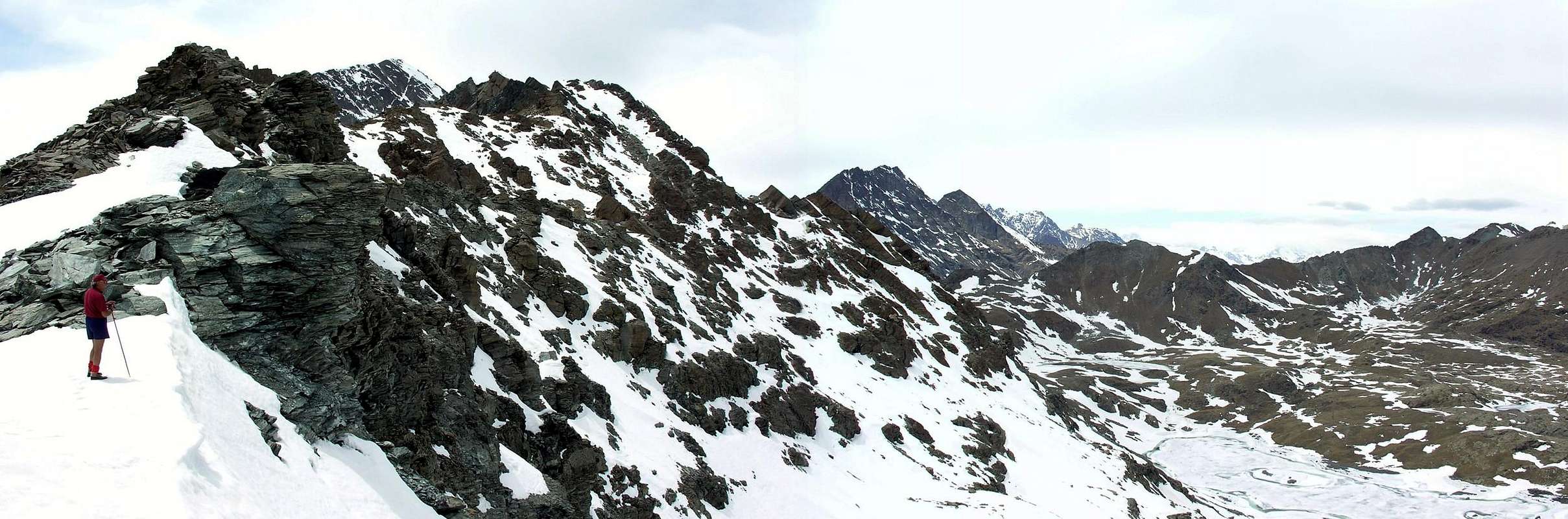
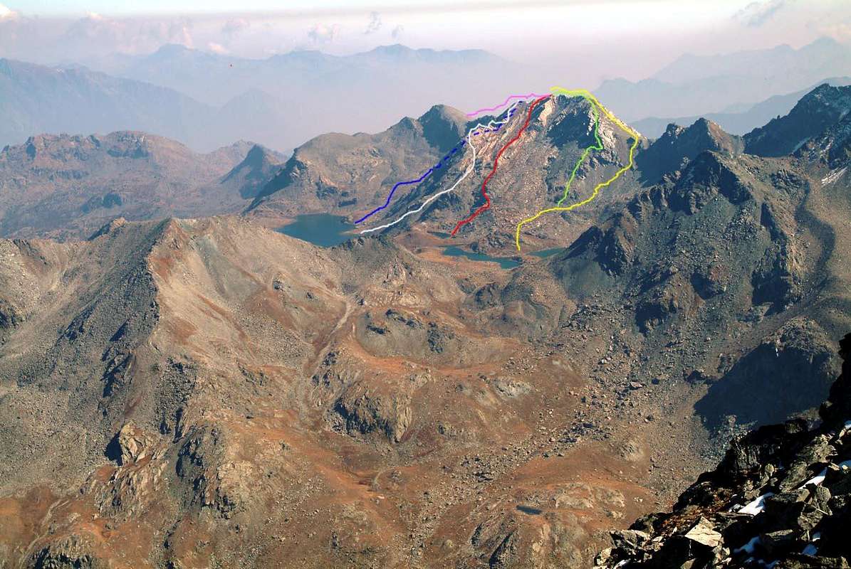
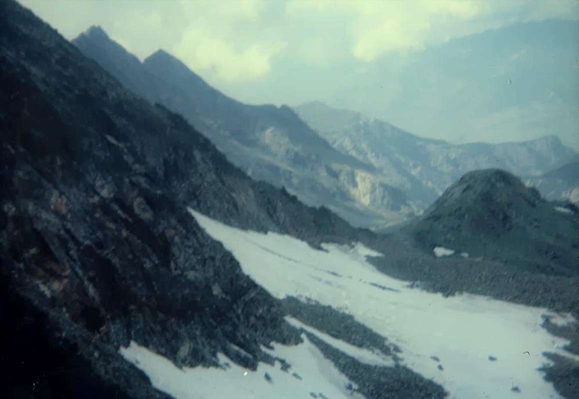
1) - From the Great Lake (2.485m) through moraines, immediately after rounding to the right (North) a small rocky promontory above the tributary, reach three tiny Leità Lakes (2.564m); from higher among these continue to the South in a narrow valley and increasingly steep scree or through snowfields reach with a small dirt track in the final part of the Northeast Pass of Gran Rossa (2.763/6m), whence the Summit with the B previous Route through the Western Ridge (3h'00/3h'15 from the shelter; see photo below).
2) - Or, starting almost from the same spot at the Grand Lake or by most Western of Lake Leità (2.564m), climb through a sinuous small spur, heading North-northwest, down from the Summit at this last ending above a stony that divides it from the same. Crossing this, get two small rocky promontories taking on the wire of the same and to climb with broken and rotten rocks that offer some fun pass (from I° to II°/II°+), which was avoidable bypassed before on the East side, then West. Easily surpassed the first, continue with a more challenging stretch above the smooth plates and inclined slabs to Northwest (F+/PD-; 1h'15/1h'30 from Leità Lake; 1h'20/1h'40 from Gran Lago).
3) - It is also possible to climb via the slope which ends with a small and triangular wall facing more to North-Northeast to Gran Lago; starting from the preceding routes to the East nearby Leità East, also about half of the Southern shore of the Great Lake, get in a true morainic narrowing, bounded by the previous North-northwest Spur and a small buttress that descends parallel between the Eastern Antesummit of Gran Rossa and Bocon Damon or Quota 2.792 meters, this last more in East. Achieved through the moraines base altitude of about 2.600/20 meters, climb in the middle of the wall through reddish rocks for very broken, often covered with debris, the overhanging slope holding no fixed course on the edge of a rocky rib that just emerges from the fairly steep scree. The same gradually increases in steepness, reaching, after passing the final part that splits "forked" down (better on his rib pointed to the left), the stone great Summit cairn (F+/PD+; 1h'30/1h'45. Starting from the most Eastern of Leità Loch calculate 0h'20 in less).
4) - And still, move through a vast stone at the base of the North Spur of the East Antesummit 2.804 meters; this goes with before reddish after brownish and compact enough for about 300 meters to Great Lake (2.485m). Starting from West or from the most Eastern Leità Lake (2.564 m) make the crossing to the Southeast, rounding the Buttress that directly descends from the Gran Rossa, to enter the next walloon as in the previous way, but more to the East, reaching a narrower morainic amphitheater, as well as at the base of the second part (the highest) of the Spur North in the direction of a small triangular wall with blackish rocks attaining the level of about 2.700/10 meters. Or are you leaving from Grand Lake to climb directly up to this point beyond a broad band of dark rocks, accompanied on both sides by debris flows, which is the natural continuation of the spur. In the first ascent of this starting point of the climb was reached with a traverse parallel higher order not to lose altitude, after the descent of West-northwest Spur of Gran Rossa. Get around to the right (West) to reach the same rocky band number of quite steep and smoothed down slabs by the ridge; pass through the four pointed elevations with little difference in the level reaching a small saddle in the form of like a half moon. From this a small crest pear-shaped leads quickly to a rounded shoulder preceding the East Antesummit of the ridge that comes from Pisonet Pass and with this the Top (PD/PD+; 0h'50/1h'00 from the base; 1h'45/2h'00 from Great; from Leità 0h'15 in less).
5) - Lastly, it is possible to reach through the North Slope of the various Quotas of the Eastern Ridge (2.804/5m, 2.734m, 2.792m, 2.746m, 2.708m), which rises from the Pisonet Col (2.734m) to East Antesummit and Summit; generally there is directed towards the first or to the last of it (even downhill). This broad side unfolds from West to East until Bocon Damon (2.792m) and the underlying Punta Jean Marquis (2.706m), which "closes" this small amphitheater above the Great Lake, so semicircular varying its exposure to Est-northeast to the North and then West-northwest. To avoid confusion we will call this off recess Slope East-northeast to distinguish it from the previous one, but mainly because the climbs are performed with greater exposure to its Western Side, logically turned more to the East. In this case, it is preferable to start climbing from the Eastern shore of the Great Lake, avoiding the long circumnavigation of the same; reached the wide enough stony upper basin, directed towards sharp rocks in the middle of the residues in the snowfields quite long summit ridge. Paying attention to the danger of falling rocks, climb quite easily the various points of the slope, if with hard snow, may require the use of ice ax and crampons but that involves a climb easier and certainly more rewarding, and somewhat less boring (F/F+; 2h'30/2h'45 from Barbustel Shelter).
 |
1) - Dal Gran Lago (2.485 m) tramite morene, subito dopo aver doppiato a destra (Nord) un piccolo promontorio roccioso soprastante l'immissario, raggiungere i tre piccoli Laghi Leità (2.564 m); dal superiore tra questi continuare verso Mezzogiorno in uno stretto vallone e per pietraie sempre più ripide o per mezzo di nevai raggiungere con una piccola traccia in terriccio nella parte finale il Colle Nordest della Gran Rossa (2.763/6 m), donde alla Sommità con la precedente Via B tramite la Cresta Ovest (3h'00/3h'15 dal rifugio).
2) - Oppure, partendo quasi dal medesimo punto presso il Gran Lago o dal Lago più Occidentale della Leità, salire per mezzo d'un piccolo sperone sinuoso che, diretto verso Nord-nordovest, scende dalla Sommità verso quest'ultimo terminando al di sopra d'una pietraia che lo divide dal medesimo. Attraversatala, raggiungere due piccoli promontori rocciosi portandosi sul filo ed arrampicare tramite rocce rotte che offrono qualche divertente passaggio (dal I° al II°/II°+), peraltro evitabile prima ad Est (meglio), poi Ovest. Superate agevolmente le prime, continuare con un tratto più impegnativo sopra placche e lastre levigate (F+/PD-; 1h'00/1h'15 dal Lago Leità; 1h'20/1h'40 dal Gran Lago).
3) - Inoltre é possibile salire tramite il versante che termina con la piccola e triangolare Parete Nord-nordest rivolta maggiormente verso il Gran Lago; partendo più verso Oriente dai precedenti due itinerari presso il Lago Leità Est oppure a circa la metà della sponda Meridionale dello stesso, entrare in un angusto valloncello morenico, delimitato dal precedente Sperone Nord-nordovest e da un contrafforte parallelo che scende tra l'Antecima Orientale della Gran Rossa ed il Bocon Damon o Quota 2.792 m. Pervenire tramite morene alla base a quota 2.600/20 m~ scalando nel mezzo per rocce rossicce ed alquanto rotte, spesso ricoperte da detriti, il versante tenendosi senza percorso obbligato sul filo d'una costola rocciosa appena emergente dalle abbastanza ripide pietraie. Lo stesso progressivamente aumenta in inclinazione, raggiungendo, dopo aver superato la parte finale che si sdoppia "biforcuta" verso il basso (meglio sulla sua costola appuntita a sinistra), direttamente la Cima (F+/PD+; 1h'30/1h'45. Dal Lago Orientale della Leità 0h'20 in meno).
4) - Ed ancora, portarsi tramite una vasta pietraia alla base del Contrafforte Nord dell'Anticima Orientale 2.804 metri; questo scende dapprima con rocce rossicce e nel tratto finale, il meno interessante, brunastre ed abbastanza compatte per circa 300 metri in direzione del Gran Lago (2.485 m). Partendo da Occidente ovvero dal più Orientale dei Laghi della Leità (2.564 m) effettuare la traversata verso Sudest, doppiando lo sperone che scende direttamente dalla Gran Rossa, per entrare nel successivo valloncello come nella precedente via ma più ad Est raggiungendo un anfiteatro morenico più ristretto, nonché alla base della seconda parte (la più elevata) dello Sperone Nord in direzione di una parete triangolare con rocce nerastre raggiungendo la quota di 2.700/10 m~. Oppure con partenza dal Gran Lago salire direttamente fino a questo punto superando una grossa fascia di rocce scure, accompagnata sui due lati da colate detritiche, costituente la naturale prosecuzione dello sperone medesimo. Nella prima ascensione questo punto di inizio della salita venne raggiunto con traversata parallela più in alto onde non perdere dislivello, dopo la discesa dello Sperone Ovest-nordovest della Gran Rossa. Aggirare a destra (Ovest) la medesima fascia rocciosa raggiungendo, tramite placche abbastanza lisce e levigate verso dabbasso, il filo di cresta; oltrepassare in successione quattro aguzze elevazioni con modesta differenza di livello raggiungendo una selletta a mezzaluna. Una crestina a forma di pera conduce in breve ad un arrotondato spallone, precedente di poco l'Antecima Est, sulla cresta che proviene dal Col Pisonet e con questa con facile traversata alla Sommità (PD/PD+; 1h'45/2h'00 dal Gran Lago; 0h'15 in meno dal Lago Leità più Orientale).
5) - Infine, é possibile raggiungere tramite il Versante Nord le varie Quote della Cresta Orientale (2.804/5 m, 2.734 m, 2.792 m, 2.746 m, 2.708 m), che sale dal Colle del Pisonet (2.734 m); in genere ci s'indirizza verso la prima o l'ultima delle stesse (pur in discesa). Questo largo versante si dispiega da Ovest verso Est fino al Bocon Damon (2.792 m) ed alla sottostante Punta Jean Marquis (2.706 m), che "racchiude" questo piccolo anfiteatro sopra il Gran Lago, in modo semicircolare variando la sua esposizione da Est-nordest a Settentrione ed infine ad Ovest-nordovest. Onde evitar confusioni chiameremo questo largo incavo Versante Est-nordest per distinguerlo dal precedente, ma soprattutto perché le salite vengono effettuate con maggiore esposizione verso il suo lato Occidentale, quindi logicamente rivolto maggiormente ad Est. In questo caso é preferibile iniziare a salire dalla sponda Orientale del Gran Lago evitando la lunga circumnavigazione del medesimo; raggiunto il discretamente ampio bacino pietroso superiore, indirizzarsi in mezzo a pietraie taglienti verso gli scarsi residui di nevati sotto l'abbastanza lunga cresta sommitale. Facendo attenzione al pericolo di caduta di pietre, piuttosto presente in mancanza di neve tal da operare da collagene vista la frantumazione della roccia, salire abbastanza facilmente i vari punti del pendio che, se in neve dura, potrebbe richiedere l'uso di piccozza e ramponi, fattore comportante certamente una salita più agevole e gratificante, nonché alquanto meno noiosa (F/F+; 2h'30/2h'45 dal Rifugio Barbustel).
 |
Difficulties
For the Normal this route can be considered EE/A; F+/PD-. For all other refer to its specification at the bottom. For a complete traverse of the Medzove Pass: A/PD/PD+.Per la Via Normale l'itinerario è classificato EE/A; F+/PD-. Per tutte le altre vedere la relativa specificazione in calce. Per la traversata integrale dal Col Medzove A/PD/PD+.
Da escursionismo.
 |
Campings
Remember that free camping is forbidden (except for emergency reasons, over 2.500m, from darkness until dawn).Mountain Conditions
- You can get meteo information at the official site of the Regione Valle d'Aosta:
- Valle d'Aosta Meteo
Webcam
- WEBCAM on Aosta Valley:
- Webcam
Books and Maps
BOOKS:- "Guida delle Alpi Occidentali" di Giovanni Bobba e Luigi Vaccarone C.A.I. Sezione di Torino Volume II (parte II), 25 Maggio 1896.
- "Guida dei Monti d'Italia – Emilius Rosa dei Banchi-Parco del Mont Avic" di Giulio Berutto e Lino Fornelli - Club Alpino Italiano/Touring Club Italiano, Marzo 2005.
- "Diari Alpinistici" di Osvaldo Cardellina e Indice Generale accompagnato da Schedario Relazioni Ascensioni 1964-2019 (inediti).
 |
 |
 |
MAPS:
- Ingenia "Parco Naturale del Mont Avic" Carta dei sentieri 1:25.000.
- Enrico Editori Ivrea "Carta turistica del Canavese" 1:100.000
- Enrico Editore Ivrea-Aosta "Gruppo del Gran Paradiso" 1:50.000.
- L'Escursionista editore "Valle di Champorcher Parco Mont Avic" Carta dei Sentieri (11) 1:25.000.
- L'Escursionista "Valle di Cogne" Carta dei Sentieri 1:25.000.
 |
 |
 |
Important Information
- REGIONE AUTONOMA VALLE D'AOSTA the official site.
- FONDAZIONE MONTAGNA SICURA Villa Cameron, località Villard de la Palud n° 1 Courmayeur (AO) Tel: 39 0165 897602 - Fax: 39 0165 897647.
- A.I.NE.VA. (Associazione Interregionale Neve e Valanghe).
Useful Numbers
- Protezione Civile Valdostana località Aeroporto n° 7/A Saint Christophe (Ao) Tel. 0165-238222.
- Bollettino Meteo (weather info) Tel. 0165-44113.
- Unità Operativa di Soccorso Sanitario Tel. 118.