
-
 9460 Hits
-
 84.27% Score
-
 18 Votes
|
|
Mountain/Rock |
|---|---|
|
|
45.67710°N / 7.55482°E |
|
|
9587 ft / 2922 m |
|
|
Overview
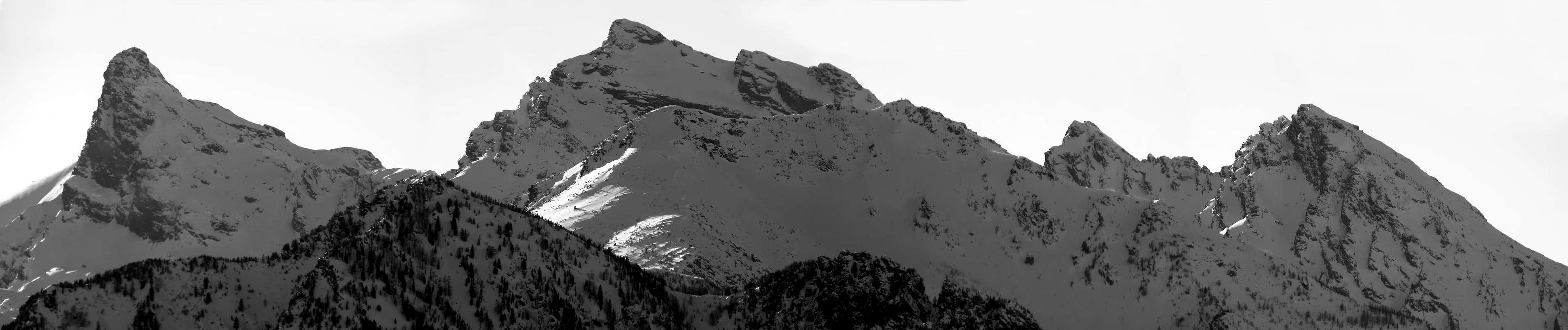
From the steeple of the Mont Avic the crest watershed among the Ponton Valley (West) and Champdepraz (East), after the Varotta Pass (2.589m), it raises again him with the Mont Ruvic (also called Mont Ruvì or through the versions with o or Rouvic and Rouvi; otherwise with e and from which therefore Revic and Revi), twin mountain of the Avic, of which it is less elegant and tall, but surely thicker. From his top it sends two great crests: the first one to North-northeast toward the Giron Pass, the Mont Giron and the Cima Nera (= Black Top), above the inhabited area of Pontey; the second crest goes down verse East-northeast in direction of the Valmeriana Pass, the Barbeston Mountain and the Lyan Mountain, above the Country of Montjovet. This last crest, also said de "Les Fourchettes", it goes down I pour the Pass of Valmeriana with a series of small towers, said also "Jags of the Ruvic", composed by discreet rock that introduces passages in climbed by the II° to the IV°-; the offered climb results however discontinuous in the difficulties. A little popular mountain and poorly frequented, especially because of the long and fatiguing approaches, grants unusual sights on the average and low Valley of Aosta.
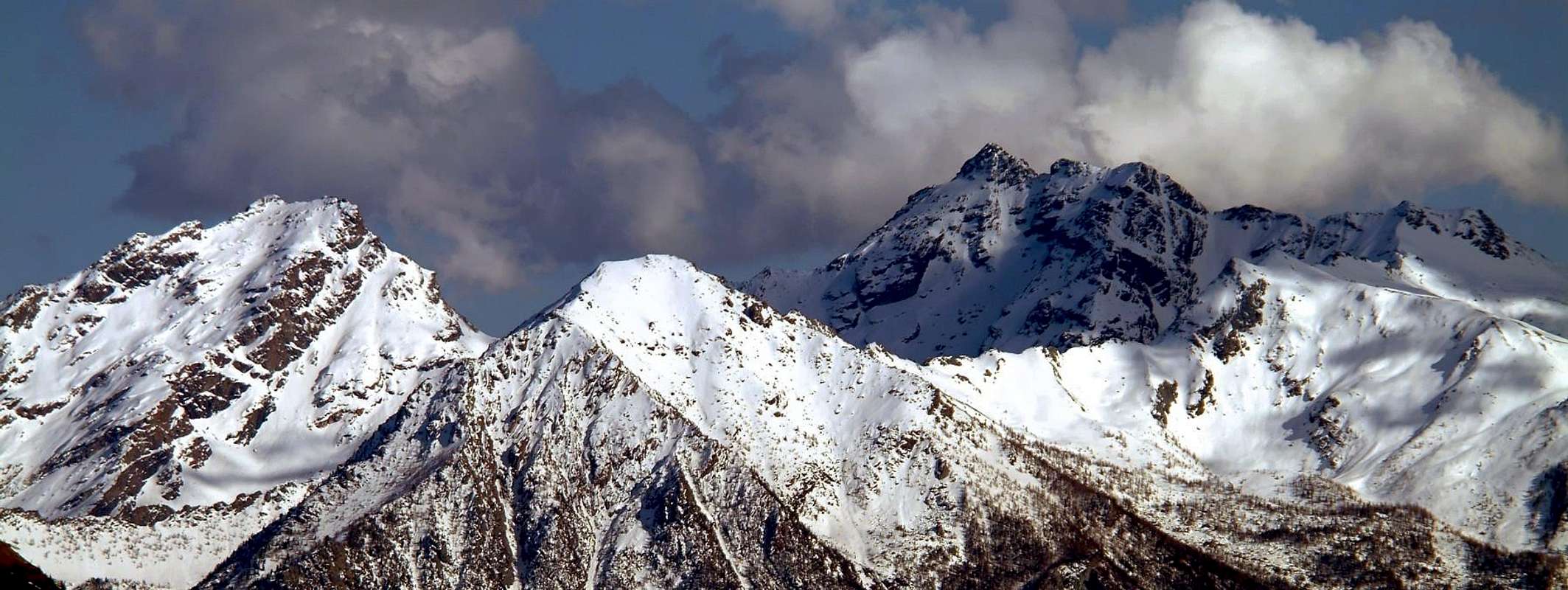
Dalla Guglia del Mont Avic la cresta spartiacque tra I Valloni Ponton (W) e Champdepraz (E), dopo il Colle Varotta (2.589 m), si rialza con il Mont Ruvic (chiamato anche Mont Ruvì, oppure con le versioni con la o e quindi Rouvic o Rouvi, altrimenti tramite la e, donde Revic e Revi), montagna gemella dell'Avic, del quale è meno elegante ed alta, ma sicuramente più massiccia. Dalla sua cima invia due grandi creste: la prima a N-NE verso il Col Giron, il Mont Giron e la Cima Nera, sopra l'abitato di Pontey; la seconda cresta scende verso E-NE in direzione del Colle di Valmeriana, il Monte Barbeston ed il Monte Lyan, sopra il Paese di Montjovet. Questa ultima cresta, anche detta de "Les Fourchettes", scende verso il Colle di Valmeriana con una serie di piccoli torrioni, detti anche "Denti del Ruvic", composti da roccia discreta che presenta passaggi in arrampicata dal II° al IV°-; l'arrampicata offerta risulta però discontinua nelle difficoltà. Montagna poco popolare e scarsamente frequentata, soprattutto a causa dei lunghi e faticosi avvicinamenti, concede viste inconsuete sulla media e bassa Valle d'Aosta.
First Ascents
- First on the summit: Unknown.
- In winter: Unknown.
- E-NE Ridge (Arete des Fourchettes): G. Actis and Amilcare Crétier; in Twenties. * First Replay: Diego Gaioni, Gigi Nordera and a group of rope climbers of the C.A.I. Verrès, (Apr 28th, 1997); ** Second Replay: Erik Bellotto, Diego Gaioni, Gigi Nordera and twentyone of rope climbers of the C.A.I. Verrès, (Jun 28th, 1998).
- W-SW Wall of the Third Jag and E-NE Ridge (Arete des Fourchettes): Michel Mottini and Paolo Zappa, (Jul 14th, 2002).
- N-NE Face (Right Side): Osvaldo Cardellina, lone, (Aug 29th, 2003), in ascent from Lusey or Luxe Village, Plan Coca, Valmeriana Pasture with descent through NO Face, Orsière Vallon to Lusey.
- N-NE Face (Left Side): Osvaldo Cardellina, lone, (Jul 04th, 2005), in ascent from Verthuy Hamlet, Forgnon Alp, Plan Coca, Valmeriana Pasture and same descent.
- N-NE Face (Central Sector): Osvaldo Cardellina, Alessandro Cardellina and Roy Cardellina, (Oct 24th, 2011), in ascent from Luxe Hamlet, Forest Bivouac, Col Varotta, W-NW Slope and S-SW Ridge, descent on N-NE Crest to Giron Collar and crossing to the base; in descent through always N-NE Crest to Giron Pass and Orsière Vallon.
- N-NE Crest (Standard Route, from Giron Pass): Unknown.
- N-NE Crest (Standard Route, from Giron Pass Integral Route): Osvaldo Cardellina, lone, (Jul 04th, 2005), in descent.
- NW Slope: Osvaldo Cardellina, lone, (Aug 29th, 2003), in descent.
- S-SW Arete (from Varotta Pass): Unknown.
![]()
Getting There
BY CAR:- From Torino, Milano, etc: Motorway A5. Exit Verrès for then to continue on SS.26 toward Champdepraz or Châtillon.
- From Switzerland: through the Grand Saint Bernard Tunnel or the namesake pass. Drive to Aosta, Châtillon or Verrès and Champdepraz.
- From France: through Mont Blanc Tunnel or Petit Saint Bernard Pass. It isn't necessary to take Motorway A5: you can drive on SS.26, in the direction of Aosta, Châtillon or Verrès.
- Aeroporto "Corrado Gex" Saint Christophe (Aosta).
Routes
* NOTE: the described routes are listed clockwise departing from the Crest N-NE or by Normal Route of ascent.* NOTA: le vie descritte vengono elencate in senso orario partendo dalla Cresta N-NE o Via Normale di salita.
Itinerary
|
Itinerary A) - from Verthuy in Valmeriana through the N-NE Ridge From Verthuy (1.050m), attainable from Chambave-Fraction Margnier (607m), to go down of at first the of of Village Cloutra (1.028m), then to follow the earth road for following of the Forgnon and Morgeron (various shortcuts), underlying a Plan Coca (1.675m; = Coca Tableland) governments toward of run wood than in the Southeast, later they affirm crossed the path coming from the the of Country Pontey (550m) and from her the of of Fraction Ussert (991m). To cross toward South the "Vallone" Molinaz to West of the homonym stream and to cross him on a bridge to quota 1.700m around; through the road "poderale" (= ground road amongst the private pastures), to go up again shortly time to the Valmeriana Alp (1.791m). Or through the path n° 1 to go up again the fund of the "Vallone" Molinaz (of Molinaz great Valley), in the mean of the splitting of the stream, thin to meet the path n° 3/4, that it originates from the Valmeriana Pasture to quota 1.910m around; shortly time to reach the alternative 1.984m that it is addressed toward the Pass of Valmeriana (2.280m; path n° 1) and Giron (2.686m; path n° 3), near the iron mine abandoned in the place of Pian of Lovo (= Lovo Tableland). To continue through the path n° 3 verse Southwest, crossing well the whole fund of the tall "Vallone" of the Valmeriana with the Mont Ruvic in sight and contained among the two Crests N and E-NE, said also Crest "des Fourchettes". Through the path (tracing in yellow color) to go up again a first prominence to quota 2.400m around; then, turning from Southwest to West-northwest, to overcome a zone characterized by great rocks rosy color (draws of very beautiful run and with a certain charm) and, through a debris little gully as well as steep interposed from some brief rocky line, to reach the small Giron or Geron Pass (2.686m). To begin along the Crest N-NE avoiding on the right (West) some small rocky jumps reaching the quota 2.731m; to easily continue toward the following quota 2.834m and, after having crossed a vast plateau of great stony ground to reach the quota 2.863m. Before a plate with almost vertical jump to South, to go down on the Slope N-NW (II°; different signalings with various little fellow in stone) and, continuing below not very under the thread of crest, easily to reach the peak for great "clapeys" (= great boulders in language of the Aosta Valley) or some snowfields residual (6h'00).
Itinerario A) - da Verthuy in Valmeriana per la Cresta N-NE Da Verthuy (1.050 m), raggiungibile da Chambave-Frazione Margnier (607 m), dapprima scendere al Villaggio di Cloutra (1.028 m), poi seguire la poderale per i successivi di Forgnon e Morgeron (scorciatoie varie), sottostante a Plan Coca (1.675 m) con percorso verso SE nel bosco, dopo aver incrociato il sentiero proveniente dal Paese di Pontey (550 m) e dalla Frazione di Ussert (991 m). Percorrere verso S il Vallone Molinaz ad O dell'omonimo torrente ed attraversarlo su di un ponte a quota 1700 metri circa; tramite la strada poderale, rimontare in breve tempo all'Alpe Valmeriana (1.791 m). Oppure per mezzo del sentiero n° 1 risalire il fondo del Vallone Molinaz, nel mezzo dello sdoppiamento del torrente, fino ad incontrare il sentiero n° 3/4, che proviene dall'Alpe Valmeriana a quota 1.910 m~; in breve tempo pervenire al bivio 1.984 m, che si indirizza verso i Colli di Valmeriana (2.280 m; sentiero n° 1) e Giron (2.686 m; sentiero n° 3), presso la miniera di ferro abbandonata, in località di Pian di Lovo. Proseguirere tramite il sentiero n° 3 verso SO, percorrendo tutto il fondo dell'Alto Vallone della Valmeriana con il Mont Ruvic ben in vista e racchiuso tra le due Creste N ed E-NE, detta anche Cresta "des Fourchettes". Per mezzo del sentiero (tracciatura in colore giallo) risalire un primo risalto a quota 2.400 m~; poi, volgendo da SO a O-NO, superare una zona caratterizzata da grandi massi color rosato (tratto di percorso molto bello e con un certo fascino) e, tramite un canalino detritico, nonché ripido, inframezzato da qualche breve tratto roccioso, raggiungere il piccolo Colle Giron o Geron (2.686 m). Iniziare lungo la Cresta N-NE evitando sulla destra (O) alcuni piccoli salti rocciosi e raggiungendo la quota 2.731 m; proseguire facilmente verso la successiva quota 2.834 m e, dopo aver attraversato un vasto plateau di grosso pietrame, raggiungere la quota 2.863 m. Prima di una placca con salto quasi verticale verso S, scendere sul Versante N-NW (II°; diverse segnalazioni con varii ometti in pietra) e, proseguendo non molto al di sotto del filo di cresta, facilmente raggiungere la vetta per grandi "clapeys" o qualche nevaio residuo (6h'00).
|


|
Itinerary B) - from Verthuy small Village in Valmeriana by the N-NE Face (West or of Right Side) With the precedent itinerary A) - up to above the first prominence to quota 2.400m around; to abandon on the right (West-southwest) the street for the Giron Pass and from the small basin of stony ground to go up again more and more her steep moraine in direction South toward the E-NE Wall (draws of slope boring and fatiguing) reaching so the base of the real wall to quota 2.770m around. To overcome the characteristic and oblong rocky band of basic on his extreme right, where this goes dark thinning dark and herself allowing the access the superior slant formed by broken rocks or, in beginning of season, from to snowcapped breadth; to easily climb this part (33°/38°; if with snow necessary ice-axe and crampons) reaching the triangular final part under the Peak. The he wins through an oblique ledge from right toward left that brings really under the peak until almost against the Crest N-NE (I°+/II° -; 38° in case of snow); a last brief passage on broken and enough steep rocks (I°/II° -) it alleges to the Summit (F+/PD -; 5h'30/6h'30, according to the state of covered with snow).
Itinerario B) - da Verthuy piccolo Villaggio in Valmeriana per la Parete N-NE (Lato Ovest o di destra) Con il precedente itinerario A)- fino a sopra il primo risalto a quota 2.400 m~; abbandonare sulla destra (O-SO) la via per il Colle Giron e dal piccolo bacino di pietrame risalire la sempre più ripida morena in direzione S, verso la Faccia E-NE (tratto di salita noioso e faticoso), raggiungendo così la base della vera e propria parete a quota 2.770 m~. Superare la caratteristica e oblunga fascia rocciosa di base sulla sua estrema destra, dove questa va sempre più assottigliandosi permettendo l'accesso al pendio superiore formato da rocce rotte oppure, in inizio di stagione, da un largo nevato; salire facilmente questa parte (33°/38°; se con neve necessari piccozza e ramponi) pervenendo alla triangolare parte finale sottostante la Vetta. La si vince tramite una cengetta obliqua da destra verso sinistra, che porta proprio sotto la vetta fino quasi contro la Cresta N-NE (I°+/II°-; 38° in caso di neve); un ultimo breve passaggio su rocce rotte ed abbastanza ripide (I°/II°-) adduce alla Sommità (F+/PD-; 5h'30/6h'30, secondo le conizioni di innevamento).
** DIRECT VARIATION (of left or East Side) From the aforesaid basin to mostly fold up toward left (Southeast) in direction of the NE Crest, where this goes to melt herself with the same wall; to go up again the slant of stony ground studded from great scattered rocks or on snowfields of moderate inclination (30°/35°). To reach so her above quoted rocky oblong band in her more oriental point; to directly go up again toward the peak overcoming a small series of five cenges in succession as well as the slant of shattered rocks overhanging rejoining himsel for the final part to the preceding itinerary or of right (from F+ to PD+; same time).
*** DIRECT CENTRAL VARIATION (Central Sector) From the aforementioned basin, bend more to the left (SE) in the direction of the NE Crest, but not reach it instead go directly up the stone slope studded with large scattered boulders, or on moderately sloping snowfields (30°/35°). Thus reaching the aforementioned oblong rocky band in its median or central point at an altitude of about 2.720 meters; overcome it via a diagonal ramp with a pitch (III°/III° + with a passage of IV°-); then, having reached the upper plateau (snowfields at the beginning of the season) , head directly towards the summit by crossing the slope of crushed rocks above (from I ° + to II ° +) from the altitude of 2.905 meters about rejoining the final part of the previous or right itinerary (from PD to PD+ and in the basal band from AD to AD+; more or less the same time). During the first ascension different approach and most long and unusual (see First Ascents).
** VARIANTE DIRETTA (di sinistra o Lato Est) Dal bacino predetto piegare maggiormente verso sinistra (SE) in direzione della Cresta NE, dove questa va a fondersi con la parete stessa; risalire il pendio di pietrame costellato da grandi massi sparsi, oppure su nevai di moderata pendenza (30°/35°). Raggiungere così la sopra citata fascia oblunga rocciosa nel suo punto più orientale; indirizzarsi direttamente verso la vetta superando una piccola serie di cinque cenge in successione, nonché il pendio di rocce frantumate soprastante ricongiungendosi per la parte finale all'itinerario precedente o di destra (da F+ a PD+; stesso tempo).
*** VARIANTE DIRETTA CENTRALE (Settore Centrale) Dal bacino predetto piegare maggiormente verso sinistra (SE) in direzione della Cresta NE, ma non raggiugere la stessa; risalire invece direttamente il pendio di pietrame costellato da grandi massi sparsi, oppure su nevai di moderata pendenza (30°/35°). Raggiungere così la sopra citata fascia oblunga rocciosa nel suo punto mediano o centrale a quota 2720 metri circa; superare la medesima tramite una rampa in diagonale con un tiro di corda (III°/III°+ con un passaggio di IV°-); quindi, raggiunto il plateau superiore (d'inizio stagione nevati), indirizzarsi direttamente verso la vetta superando il pendio di rocce frantumate soprastante (dal I°+ al II°+) da quota 2905 metri circa nonché ricongiungendosi per la parte finale all'itinerario precedente o di destra (da PD a PD+ e nella fascia basale da AD ad AD+; più o meno stesso tempo).Durante la prima ascensione approccio molto differente oltreché molto più lungo ed inusuale (vedi First Ascents).
|
|
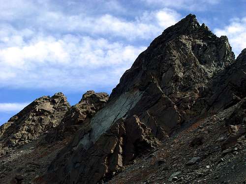
Itinerary C) - from Verthuy in Valmeriana by the W-SW Face of the Third Jag (2459m around, by altimeter) and through the NE Ridge. From the original Report of Doctor Michel Mottini: "Quota 2.459m around (altimeter) APPROACH. Along the road excavated that it brings to the pasture and from here to continue along the path that brings to the Barbeston on the in general Valmeriana. From the bifurcation under the pass x traces of path he arrives under the well evident wall. Descent. Arrived on the top to go down to sx x traces of path up to the pass among 2° and the 3° jag; from here to go down in the gully up to the base. I° PITCH or Draught of rope: For easy plates fessurate up to the great ledge, to stop 25m under the cracks of the 2° T. (5c) II° PITCH: The parallel cracks follow you using those of middle greatness 45m not the scene to SX and not the great to DX, thin to arrive (5c/6a) some meter under the roof on a small terrace of 10cm (nail). III° PITCH: Middle crack that enters and it cuts the roof, continues then toward first dx 45m + easy then more it flares and on smooth plate for the feet small terrace (6a+/6b+): ledge of 10cm, to continue to thin dx on the edge, to go out to sx in great crack on 1° antesummit. IV° PITCH: To go down collar between antesummit and final wall 2° (eye!!) vertical thin to reach a big rock under the top (5c) real. Here to stop. Meriana Valley (Third Jag of the Mount Ruvi) 160m max 6bB+ Everything climbed cleen (= without other artificial means) - the standstill of S2 where a nail there is."
Itinerario C) - dal Villaggio di Verthuy in Valmeriana per la Parete O-SO del Terzo Dente (2.459m circa, tramite altimetro) e la Cresta NE Dalla Relazione originale del Dottor Michel Mottini: "Quota 2459 m~ (altimetro) AVVICINAMENTO. Lungo la strada sterrata che porta all'alpeggio e da qui proseguire lungo il sentiero che porta al Barbeston sul lato Valmeriana. Dalla biforcazione sotto il colle x tracce di sentiero si arriva sotto la parete ben evidente. Discesa. Arrivati sulla cima scendere a sx x tracce di sentiero fino al colle tra il 2° ed il 3° dente; da qui scendere nel canalone fino alla base. I° T: Per facili placche fessurate fino alla cengia grande, sostare 25m sotto le fessure del 2° T. (5C) II° T: Si seguono le fessure parallele utilizzando quelle di grandezza media 45 metri non la quinta a SX e non la grande a DX, fino ad arrivare (5c/6a) qualche metro sotto il tetto su un terrazzino di 10cm (chiodo). III° T: Fessura di mezzo che entra e taglia il tetto, poi prosegue verso dx prima 45 m + facile poi più svasa e su placca liscia per i piedi terrazzino (6a+/6b+): cengia di 10 cm, proseguire a dx fino sullo spigolo, uscire a sx in fessurona su 1° anticima. IV° T: Scendere colletto tra anticima e muro finale 2° (occhio!!) verticale fino ad arrivare a un grosso masso sotto la cima (5C) vera e propria. Qui sostare. V. Meriana (3 d. M. Ruvi) 160m max 6b+ Tutto salito cleen (= senza altri mezzi artificiali) – la sosta di S2 dove c'è un chiodo."
|


|
Itinerary D) - from Verthuy in Valmeriana by the Valmeriana's Pass and through the NE Ridge Through the precedents itineraries up to the alternative among the paths n° 1/3 near a small stream with signalings on a flat rock positioned to level of the ground; to abandon on the right (West-southwest) the path n° 3 for the Giron Pass, continuing instead toward right (Southeast) through the path n° 1 in direction of the Valmeriana Pass (2.261m), sets to horse among the Barbeston Mountain (2.482m) and the NE Ridge or "des Fourchettes" of the Mount Ruvic. To go up again the Slope N-NW of the pass with a series of narrow hairpin bends along the beautiful path restructured by the Foresters (E; 3h'30/4h'00 from Verthuy; 1h'30 from the Valmeriana Pasture). From the hill to gradually follow then the long first crest with direction Northeast up to the Quota 2.459m or Third Jag from East-northeast to East in the terminal part meeting difficulty from the II° to the IV°, a lot of of which besides avoidable with avoidances along the two Slopes E and W (from PD to AD+, with integral run on the thread of crest; 7h'00/8h'00 from Verthuy; 3h'30/5h'00 from the Pass of Valmeriana, according to the select passages).
Itinerario D) - dal Villaggio di Verthuy in Valmeriana per il Colle di Valmeriana ed attraverso la Cresta NE Tramite i precedenti itinerari fino al bivio tra i sentieri n° 1/3 presso un piccolo torrente con segnalazioni su di un masso piatto posizionato a livello del terreno; abbandonare sulla destra (O-SO) il sentiero n° 3 per il Colle Giron, proseguendo invece verso destra (SE) per mezzo del sentiero n° 1 in direzione del Colle di Valmeriana (2.261 m), posto a cavallo tra il Monte Barbeston (2.482 m) e la Cresta NE o "des Fourchettes" del Mont Ruvic. Risalire il Versante N-NO del colle con una serie di stretti tornanti lungo il bel sentiero ristrutturato dalla Guardie Forestali (E; 3h'30/4h'00 da Verthuy; 1h'30 dall'Alpe Valmeriana). Dal colle seguire la lunga cresta prima con direzione NE fino alla Quota 2.459 m o Terzo Dente poi gradualmente da E-NE ad E nella parte terminale, incontrando difficoltà dal II° al IV°, molte delle quali peraltro evitabili con aggiramenti lungo i due Versanti E ed O (da PD ad AD+, con percorso integrale sul filo di cresta; 7h'00/8h'00 da Verthuy; 3h'30/5h'00 dal Colle di Valmeriana, a seconda dei passaggi scelti).
|
|
Itinerary E) - from Champdepraz Village through the Valmeriana Pass and by the NE Ridge From Veulla (1.248m) with the following itinerary F) - up to the alternative 1.340m around, before the Alp Pra Oursi or Praz Orsie Pasture; abandoning the path n° 7 near a small bridge on a brook, that continuous verse West in direction of the Varotta Pass, to turn instead I pour right and to climb verse N-NE with the path n° 7b for the Valmeriana’s Pass (2.261m). The same medium to long diagonal through the wood, leaving in low to East the You Nouva Alp, and over past to ruin, reaches the Alpe of Pian Castello, better known on the spot as Pian Tsate Pastures (1.996m; And; 1h'30/2h'00 from Veulla Village); the same continuous in direction of the Slope S of the Mountain first Barbeston with traces not always well evident, dark then marked and you mark in yellow color up to rates 2.100m around, where with to last turned hairpin bend to West and to brief diagonal toward left it deposits to the pass (And; 2h'00/2h'30 from Veulla Village). From the Pass of Valmeriana, turning to Southwest at first for easy meadow backs and therefore with the itinerary D) - precedent through the NE Crest the Peak is earned (from PD to AD+, with integral run on the thread of crest; 5h'30/6h'30 from Veulla; 3h'30/5h'00 from the Valmeriana's Pass, according to the select passages).
Itinerario E) - dal Paese di Champdepraz per il Colle di Valmeriana e per la Cresta NE Da Veulla (1.248 m) con il successivo itinerario F)- fino al bivio 1.340 metri circa, prima dell'Alpe Pra Oursi o Praz Orsie; abbandonando il sentiero n° 7 presso un piccolo ponte su di un ruscello, che continua verso O in direzione del Colle Varotta, girare invece verso destra e salire verso N-NE con il sentiero n° 7b per il Colle di Valmeriana (2.261 m). Lo stesso tramite un lungo diagonale attraverso il bosco, lasciando in basso ad E l'Alpe La Nouva, e oltre passato un rudere, raggiunge l'Alpe di Pian Castello, meglio conosciuta in loco come Pian Tsate (1.996 m; E; 1h'30/2h'00 dal Villaggio di Veulla); lo stesso continua in direzione del Versante S del Monte Barbeston prima con tracce non sempre ben evidenti, poi più marcate e segnate in colore giallo fino a quota 2.100 metri circa, dove con un ultimo tornante rivolto ad O ed un breve diagonale verso sinistra deposita al colle (E; 2h'00/2h'30 da Veulla). Dal Colle di Valmeriana, volgendo a SO dapprima per facili dossi prativi e quindi con l'itinerario D)- precedente tramite la Cresta NE si guadagna la Vetta (da PD ad AD+, con percorso integrale sul filo di cresta; 5h'30/6h'30 da Veulla; 3h'30/5h'00 dal Colle di Valmeriana, a seconda dei passaggi scelti).
|
|
Itinerary F) - from Champdepraz through the Varotta Pass and by the S-SW Crest From Champdepraz Village (attainable in 2 Km from the alternative of Verrès Town) to climb with the carriage one to the Fraction of You Villas or Veulla or Volla (1.248m; P); for the carrareccia (= earth road) toward the "Store" to actually go up again to the fork to quota 1.340m around that it brings to Praz Orsie or Pra Oursi Pasture. To continue verse West and, gone beyond two brooklets, to reach a second of it; to leave the branch of right (North) for Pian Tsatsé reaching Praz Orsie Alp (1.794m) end the following ruins of the Alpe Fié (2.080m), a source as well as the superior Pian de Fié or Plan de Fì (= Fié Tableland). To cross him in direction W-NW since almost against the alert Wall South of the Mount Ruvic and, through a morainic crest with trace of path, to aim in direction of a well distinguishable boulder; therefore, diverting to the left slightly (Southwest), shortly the Varotta Pass is reached (2.591m; 3h'30/4h'00). To climb for the easy Crest SW (from the pass the same one appears more difficulty than it results in reality) in direction of the Peak SW (2.906m), the only visible from this point, with the form of great tower; supporting to the left herself (West) through wrecks and deposits, to arrive, after having overcome two rocky bands "broken", to a rocky rib. With run not forced, to cross her in direction of a great jump that he leaves on the right; staying to Northwest to reach through debris of it terrestrial a second, always revolt toward the Ponton great Valley, and through little rocks to reach the Antesummit 2.906m. From this point the ridge decidedly changes direction from Northeast to East-northeast (watershed on the Comba of Orsière; = Orsière Basin) and it easily concludes to the maximum Peak (From F+ up to PD -; 4h'45/5h'30, especially in consideration of the knowledge of the route).
Itinerario F) - da Champdepraz per il Colle Varotta e per la Cresta S-SO Dal Paese di Champdepraz (raggiungibile in 2 Km dal bivio di Verrès) salire con la carrozzabile alla Frazione di La Ville o Veulla o Volla (1.248 m; P); per la carrareccia verso il "Magazzino" risalire sino al bivio a quota 1.340 m~ che porta a Praz Orsie o Pra Oursi. Proseguire verso O e, oltrepassati due torrentelli, raggiungerne un secondo; lasciare il ramo di destra (N) per Pian Tsatsé raggiungendo Praz Orsie (1.794 m) ed i successivi ruderi dell'Alpe Fié (2.080 m), una sorgente nonché il soprastante Pian de Fié o Plan de Fì. Percorrerlo in direzione O-NO sin quasi contro l'erta Parete Sud del Mont Ruvic e, per mezzo di una cresta morenica con traccia di sentiero, puntare in direzione di un macigno ben distinguibile; quindi, deviando leggermente a sinistra (SO), in breve si raggiunge il Colle Varotta (2.591 m; 3h'30/4h'00). Salire per la facile Cresta SO (dal colle la stessa appare più difficile di quanto risulta in realtà) in direzione della Vetta SO (2.906 m), l'unica visibile da questo punto, con la forma di grande torre; appoggiandosi a sinistra (O) tramite rottami e detriti, arrivare, dopo aver superato due fasce rocciose "spezzate", ad una costola rocciosa. Con percorso non obbligato, percorrerla in direzione di un grande salto che si lascia sulla destra; restando a NO raggiungerne per mezzo di terreno detritico una seconda, sempre rivolta verso il Vallone del Ponton, e per mezzo di roccette arrivare all'Anticima 2.906 m. Da questo punto la cresta cambia decisamente direzione da NE a E-NE (spartiacque sulla Comba di Orsière) e conclude facilmente alla Vetta massima (Da F+ a PD-; 4h'45/5h'30, soprattutto in considerazione della conoscenza del percorso).
|
|
Itinerary G) - from Lusey and through the Valley of Ponton Arete and the N-NW Slope From Lusey or Luxe Damon (you see the itinerary H)- following) to address him toward Southeast I cross the wood with the path of connection n° 3 with Verthuy Village, reaching the stream coming from the great Valley understood among the Arete de Ponton to West and the triptych Mount Ruvic/Mount Giron/Cima Nera to East to quota 1.650m around; to go up again on the fund of the small and narrow "vallone" and along the same stream bringing himself in direction of the moraine overlooking reaching her to quota 1.950/2.000m around. Without forced run, to rather go up again her in wild environment first toward South, then gradually folding up toward Southeast, leaving on the left (East) a small and steep secondary valley that directly brings Giron to the Pass, and coming so at the base of the imposing N-NW Slope of the Mount Ruvic. To go up again him with a gradient of over 900 meters, passing a first inclusive rocky band among a descending rocky ribbing from the Crest N-NE and a second coming from the Antesummit W-SW about the Mount Ruvic; almost climbing on-line vertical in direction of the maximum Peak, to easily overcome a second rocky band to around half crossed. To penetrate him so in the superior part composed by slant debris, "clapeys" (= great blocks in language of the Aosta Valley) alternated to small rocks; doubling on the right a minuscule rocky promontory the final part is overcome again for great blocks and splinters. They avoids the terminal rocks supporting to the right slightly on the small saddle between the Peak and the Antesummit W-SW and, through the small rocks of the little and summital crest watershed, easily the Top is reached (EE/A; 6h'00/7h'00 from Lusey little Village).
Itinerario G) - da Lusey lungo il Vallone dell'Arete de Ponton ed il Versante N-NW Dal Villaggio di Lusey o Luxe Damon (vedi l'itinerario H)- successivo) indirizzarsi verso SE attraverso il bosco con il sentiero di collegamento n° 3 con il Villaggio di Verthuy, raggiungendo il torrente proveniente dal Vallone compreso, tra l'Arete de Ponton ad O ed il trittico Mont Ruvic/Mont Giron/Cima Nera ad E a quota 1.650 m~; risalire sul fondo del piccolo e ristretto vallone e lungo il torrente stesso, portandosi in direzione della morena soprastante raggiungendola a quota 1.950/2.000 m~. Senza percorso obbligato, risalirla in ambiente alquanto selvaggio prima verso meridione, poi piegando gradualmente verso SE, lasciando sulla sinistra (E) un piccolo e ripido valloncello secondario che porta direttamente al Colle Giron, e giungendo così alla base dell'imponente Versante N-NO del Mont Ruvic. Risalirlo con un dislivello di oltre 900 metri, passando una prima fascia rocciosa compresa tra una nervatura rocciosa discendente dalla Cresta N-NE ed una seconda proveniente dall'Antecima O-SO del Mont Ruvic; salendo in linea pressocché verticale in direzione della Vetta massima, superare agevolmente una seconda fascia rocciosa a circa metà percorso. Addentrarsi così nella parte superiore composta da pendii detrici, grandi blocchi, detti in patois valdostano "clapeys", alternati a roccette; doppiando sulla destra un minuscolo promontorio roccioso, si supera la parte finale ancora per grandi blocchi e frantumi. Si evitano le rocce terminali appoggiando leggermente sulla destra sopra la appena accentuata sella tra la Vetta e l'Antecima O-SO e, tramite le roccette della crestina sommitale spartiacque, facilmente si raggiunge la Cima (EE/A; 6h'00/7h'00 da Lusey).
|
|
Itinerary H) - from Lusey and through the Ponton Valley, the Varotta Pass and the S-SW Crest From Lusey or Luxe Damon little Village (1.160m), attainable from Chambave-Fraction Arlier or Arly (582m) through the earth road "interpoderale" (dam to the traffic to quota 936m) or through the path n° 4, address us verse Sout-southwest through the Wood of Bon, meeting, road doing, first a source, then a small valley/mountain range/promontory in the Bois de Ponton (= Ponton Forest). They follow two small descents and subsequently the crossing of a short stony ground, follows I immediately approach from a landslide (protected from fence), a tilted plan, as well as a second landslide, also this protected from enclosure in wood. Always revolving on the side West Ponton Ridge, to leave on the right the alternative for the Ponton Pasture and to reach the alternative instead 2.140m around; the same is addressed I pour the Varotta Pass to Southeastf and I pour the I Camp out of the Forest one in direction South. Through a brief detour to reach him (2.169m) in the proximities of a gigantic boulder (cave for possible shelter, since the I camp out youe is deprived and therefore closed, on the southern side of the same); to find some water however it is necessary to go himself thin against the rocky and blackish banconates of the Crest W of the Avic Mountain, through an little valley debris in direction Southeast. Or from the alternative 2.140m around to continue pour the Varotta Pass with system of signs in more abundant yellow color and surely exaggerated, so much to be bothered. To abandon verse Southeast to deviation with lower houses letter trace that is addressed toward the Avic Mountain and to overcome to first steep and fatiguing ramp, to following casting debris coming from the same pass, to second ramp similar to the preceding one up to lick up the Crest W of the Mont Ruvic; turning to east to pass near to great reddish rock and, through to less steep diagonal from the left toward the right or Southeast, to easily reach the pass. To conclude along the Crest SW, as for the itinerary A. (From F+ to PD -; 5h'30/6h'00).
Itinerario H) - da Lusey lungo il Vallone del Ponton, il Colle Varotta e la Cresta S-SW Dal piccolo Villaggio di Lusey o Luxe Damon (1.160 m), raggiungibile da Chambave-Frazione Arlier o Arly (582 m), tramite la strada interpoderale (chiusa al traffico a quota 936 m), oppure per mezzo del sentiero n° 4, ci si indirizza verso S-SO attraverso il Bosco di Bon, incontrando, strada facendo, prima una sorgente, poi una valletta/giogaia/promontorio nel Bois de Ponton. Seguono due piccole discese e successivamente l'attraversamento di una corta pietraia, seguito subito appresso da una frana (protetta da staccionata), un piano inclinato, nonché una seconda frana, anche questa protetta da recinzione in legno. Sempre aggirando sul lato O l'Arete de Ponton, lasciare sulla destra il bivio per l'Alpe Ponton e raggiungere invece il bivio 2.140 m~; lo stesso si indirizza verso il Colle Varotta a SE e verso il Bivacco della Forestale in direzione S. Tramite una breve digressione raggiungerlo (2.169 m) nelle vicinanze di un macigno gigantesco (grotta per eventuale riparo, poiché il bivacco è privato e quindi chiuso, sul lato meridionale dello stesso); per trovare dell'acqua però è necessario portarsi fino contro le banconate rocciose e nerastre della Cresta O del Monte Avic, per mezzo di una valletta detritica in direzione SE. Oppure dal bivio 2.140 m~ proseguire verso il Colle Varotta con segnaletica in colore giallo più che abbondante e sicuramente esagerata, tanto da dare fastidio. Abbandonare verso SE una deviazione con minuscola traccia, che si indirizza verso il Monte Avic, e superare una prima rampa ripida e faticosa, una successiva colata detritica proveniente dal colle stesso, una seconda rampa simile alla precedente fino a lambire la Cresta O del Mont Ruvic; volgendo ad oriente, passare presso una grande roccia rossastra e, tramite un diagonale meno ripida dalla sinistra verso la destra ovvero SE, raggiungere facilmente il colle. Concludere lungo la Cresta SO, come per l'itinerario A (Da F+ a PD-; 5h'30/6h'00).
|
 |
 |
Difficulty
The routes are considered to be F+ up to AD+.Gli itinerari sono da considerarsi da F+ a AD+.
Equipment
Standard mountaineering equipment and rope; carabiners and nails for the NE Ridge and for the Route of the Third Jag.Da alpinismo con la corda; moschettoni e chiodi da roccia per gli itinerari della Cresta NE e per la Via alla Parete Ovest del Terzo Dente.
Campings
Remember that free camping is forbidden (except for emergency reasons, over 2.500m, from darkness until dawn).Mountain Conditions
- You can get meteo information at the official site of the Regione Valle d'Aosta:
- Valle d'Aosta Meteo
Webcam
- WEBCAM on Aosta Valley:
- Webcam
Books and Maps
BOOKS:- "Guida delle Alpi Occidentali" di Giovanni Bobba e Luigi Vaccarone C.A.I. Sezione di Torino Volume II (parte II), 25 Maggio 1896.
- "Guida dei Monti d'Italia–Emilius Rosa dei Banchi Parco del Mont Avic" di Giulio Berutto e Lino Fornelli-Club Alpino Italiano/Touring Club Italiano, Marzo 2005 (in Italian).
- "A piedi in Valle d'Aosta" (Vol. 2), di Stefano Ardito, Ed. Guide iter, Giugno 2004.
- "I Rifugi della Valle d'Aosta" di Stefano Ardito, Ed. Guide iter, Febbraio 2003.
- "Rifugi e bivacchi in Valle d'Aosta", di Cosimo Zappelli aggiornata da Pietro Giglio, Musumeci Editore, Luglio 2002.
- "G. Klotz "Gran Paradiso" Ed. Bergverlag GmbH Rother, Monaco 2005 (in tedesco).
- "Guida della Regione Autonoma Valle d'Aosta" di Mario Aldrovandi; Ed. S.P.E. di Carlo Fanton, Torino 1964.
- "Diari Alpinistici" di Osvaldo Cardellina e Indice Generale accompagnato da Schedario Relazioni Ascensioni 1964-2019 (inediti).
- "Parco Naturale Mont Avic" di Naldo Finco e Luca Zavatta, l'Escursionista Ed., Giugno 2006.
- "Ascensioni in Valle d'Aosta 1921-1933" Diario Alpinistico di Amilcare Crétier; Edizione Sezione di Verres del C.A.I. e Biblioteca di Vèrres, stampa Arti Grafiche Tamari Bologna, Luglio 1993 (in Italian).
 |
 |
 |
 |
 |
 |
 |
 |
MAPS:
- Kompass "Gran Paradiso Valle d'Aosta Sentieri e Rifugi" Carta Turistica 1:50.000.
- L'Escursionista "Parco Naturale del Mont Avic" Carta dei Sentieri 1:25.000.
- Enrico Editore Ivrea-Aosta "Gruppo del Gran Paradiso" 1:50.000.
- I.G.C. Istituto Geografico Centrale Torino "Ivrea Biella Bassa Valle d’Aosta" (n° 9), 1:50.000.
- I.G.C. Istituto Geografico Centrale Torino "Il Parco Nazionale del Gran Paradiso" (n° 3), 1:50.000.
- Ingenia "Parco Naturale del Mont Avic" Carta dei Sentieri 1:25.000.
- Hapax "Les Sentiers Comunità Montana Monte Emilius", Luglio 2000 1:25.000.
- Hapax "Les Sentiers de Champorcher" Comune di Champorcher, Agosto 2001, 1:25.000.
Important Information
- REGIONE AUTONOMA VALLE D'AOSTA the official site.
- FONDAZIONE MONTAGNA SICURA Villa Cameron, località Villard de la Palud n° 1 Courmayeur (AO) Tel: 39 0165 897602 - Fax: 39 0165 897647.
- A.I.NE.VA. (Associazione Interregionale Neve e Valanghe).
External Links
Useful Numbers
- Protezione Civile Valdostana località Aeroporto n° 7/A Saint Christophe (Ao) Tel. 0165-238222.
- Bollettino Meteo (weather info) Tel. 0165-44113.
- Unità Operativa di Soccorso Sanitario Tel. 118.
Acknowledgements
I am greatly indebted to my friends "Osva" and Michel Mottini for the detailed description of the route and to Osvaldo for the translation into English.