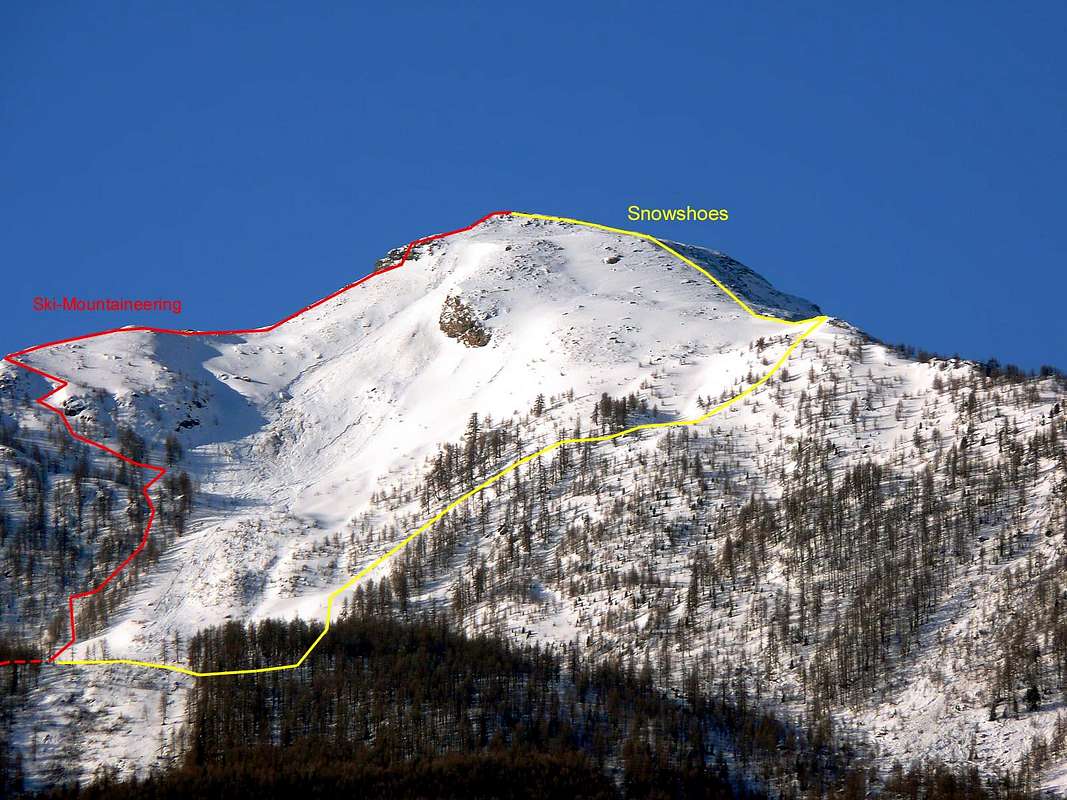
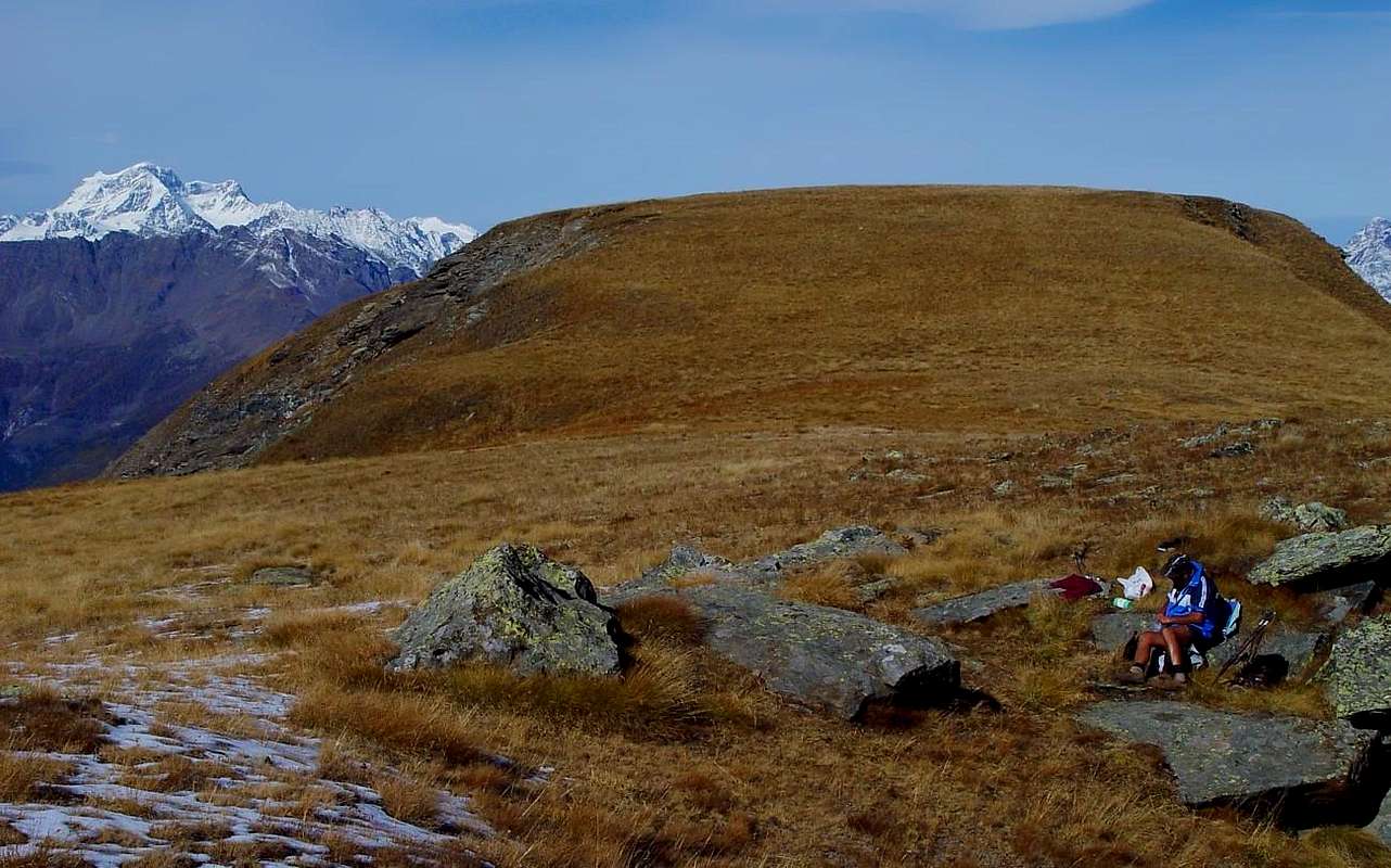
Mountain looking as a big grassy and rocky cake, positioned to the beginning, immediately afterwards the N-NW Crest to Mount Roux (2.277m; iron and coppermines, by now closed from over half century) and the N-NE Ridge through the Torrasse or Touriasse (1.895m) and the Mount Saint Julien (1.384m; beautiful Sanctuary of Saint Grat near the Summit and Hermitage of Saint Julien below and characteristically "perched" into East Wall, with nearby a splendid Rocky Gym), of the crest long watershed dividing the Valleys of Saint west Marcel and of Fénis-Clavalitè to East, immediately to South of the two Villages of the Les Druges Basse (= Lower) and the Les Druges Alte (= Higher), just to entrance of the Nature Reserve by Marquis Turati, ex Reserve Peck Peck(c)oz Baron, KINGDOM of the STEINBOCK and the EAGLE. Very popular for ski-mountaneering and hiking. It has three ridges, the North-northwest toward the Mont Roux (2.277m) and to South-southeast toward the Col de Crotey (2.486m) on the long Southern ridge going, progressively after the elevations of Plan Rué Point, the Arete of the Devil also Great Crest, the Great and Little Averts, the Lavodilec Pass and the Tessonet Point, to the Punta Tersiva (3.515m) and the Northeast ending above the ruins of Prapremier (2.011m; by this time to ruins) Pastures. The third crest, as already previously reported in the initial preamble, from the "alpage" it goes down toward North-northeast, true and logic prosecution of watershed Saint Marcel/Fénis Municipalities, in direction of San Giuliano, for then to fall, rocky, on the inhabited area of the Commune of Fénis. All the ridges are good for an easy hiking, while the last one, joined to the debris N side is good for ski-mountaneering. To such intention, from to underline as the run, however simple and not difficult, asks for prudence and to good evaluation of the time and the degree of transformation of the snow, being already occurred accidents, also deadly, causes the separation of the avalanche on the median and underlying line the Northern Slope (as he underlines well in the various photos); it is worthwhile to mostly lean on himself on the left (East) holding himself against, if not even to the inside, of the first line of larchs. Also the opposite is practicable also the Crest, or N-NW, with the same shrewdness of the preceding one and therefore exploiting that small gully space curdled among the two parts of the forest. The same is really recommended in case of strong snow presence and alternative slope by the snow rackets or snowshoes. You dissuades instead, under these conditions, the run through the With the Crotey for his dangerousness, at least as it regards the Slope Fénis; surer and approachable instead the itinerary appears through the same, but reaching it from the Walloon of Saint Marcel and transiting for the homonym alps (2.348m Dèsot or Lower and 2.358m Damon also Superior). Ample views on the in general Northern orographic of the Dora Baltea Stream and on the Range of the neighbour Great Roise that is risen opposite, while in distance the Cervino also Matterhorn towers, that dominates the Valley, with to his shoulders the colossuses of the Vallese from this point. To Southeast great quick glimpse on neighbour Mount Raf(f)rey (3.146m) at the end of Clavalité-Val Fénis Valley.
Montagna dalla forma di grande panettone roccioso-erboso, posizionata all'inizio, subito appresso le due creste che discendono al Mont Roux verso N-NO (2.277 m; miniere di ferro e rame, ormai chiuse da oltre mezzo secolo) ed alla Torrasse oppure Touriasse (1.895 m) ed al Mont Saint Julien a N-NE (1.384 m; bel Santuario di San Grato presso la Sommità ed Eremo di Saint Julien caratteristicamente "appollaiato" appena sotto ed all'interno della Parete Est, con vicino ottima Palestra di Roccia), della lunga cresta spartiacque divisoria le Valli di Saint Marcel ad Occidente e di Fénis-Clavalité ad Oriente, subito a S dei due Villaggi di Les Druges Basse ed Alte, all'ingresso del bel Vallone di Saint Marcel con la Riserva Naturale del Marchese Turati, ex Riserva del Barone Beck Peck(c)oz, REGNO dello STAMBECCO e dell'AQUILA. Molto frequentata per l'escursionismo e lo sci-alpinismo. Presenta tre creste rivolte a N-N-W verso il Mont Roux (2.277 m) e nel senso opposto, dopo la vasta spianata erbosa della cima, a S-S-E verso il Col de Crotey (2.486 m), nella lunga dorsale Meridionale che, dopo aver formato in progressione la Punta di Plan Rué, la Cresta del Diavolo o Gran Cresta, il Grand'Avert ed il Piccolo, il Colle di Lavodilec e la Punta del Tessonet, giunge sino alla Punta Tersiva (3.515 m), ed a N-E terminante sopra l'Alpeggio diroccato di Prapremier (2.011 m). La terza cresta, come già precedentemente riferito nel preambolo iniziale, scende, vera e logica prosecuzione dello spartiacque tra i Comuni di Saint Marcel/Fénis, verso N-NE in direzione di San Giuliano, per poi precipitare, rocciosa, sull'abitato del Comune di Fénis. Tutte le tre creste sono di facile percorso escursionistico, mentre l'ultima citata, nel tratto finale associata alla prima parte sul detritico versante Nord, costituisce una classica dello sci-alpinismo. A tal proposito, da sottolineare come il percorso, per quanto semplice e non difficile, richieda prudenza ed una buona valutazione del tempo e del grado di trasformazione della neve, essendosi già verificati incidenti, anche mortali, causa il distacco della valanga sul tratto mediano e sottostante il Versante Settentrionale (come si evidenzia bene nelle varie fotografie); all'uopo conviene appoggiarsi maggiormente sulla sinistra (E) tenendosi contro, se non addirittura all'interno, della prima fila di larici. Altresì é percorribile in sci-alpinismo anche la cresta dirimpettaia, o N-NO, con i medesimi accorgimenti della precedente e quindi sfruttando quel piccolo canalone-spazio rappreso tra le due parti della foresta. La stessa é proprio, da parte nostra, consigliata in caso di forte innevamento e quindi tramite salita alternativa per mezzo delle racchette da neve. Si sconsiglia invece, in queste condizioni, il percorso tramite il Col Crotey per la sua pericolosità, almeno per quanto concerne il Versante Fénis; più sicuro ed abbordabile invece appare l'itineraio tramite lo stesso, ma raggiungendolo dal Vallone di Saint Marcel e transitando per le omonime alpi (2.348 m Dèsot e 2.358 m Damon). Ampie vedute sul lato orografico Settentrionale della Dora Baltea e sulla Catena della Grande Roise che si erge dirimpetto, mentre in lontananza troneggia il Cervino, che da questo punto domina la Valle, con alle sue spalle i colossi del Vallese. Verso il Sudest splendido colpo d'occhio sul viciniore Mont Raf(f)rey (3.146 m), al termine della Vallata di Clavalité-Fénis.
First Ascents
First on the summit: Unknown.
In Winter: Unknown.
Getting There
BY CAR:
From Torino, Milano, etc: Motorway A5. Exit Aosta est For Grand Brissogne and Saint Marcel.
From Switzerland: through the Grand St. Bernard Tunnel or the homonym Pass. Drive to Aosta, For Grand Brissogne and Saint Marcel. From France: through Mont Blanc Tunnel or Petit St. Bernard Pass. It isn't necessary to enter in Motorway A5, you can drive through SS.26 Aosta direction. Exit Aosta est For Grand Brissogne and Saint Marcel.
BY PLANE:
Aeroporto "Corrado Gex" Saint Christophe (Aosta).
Routes
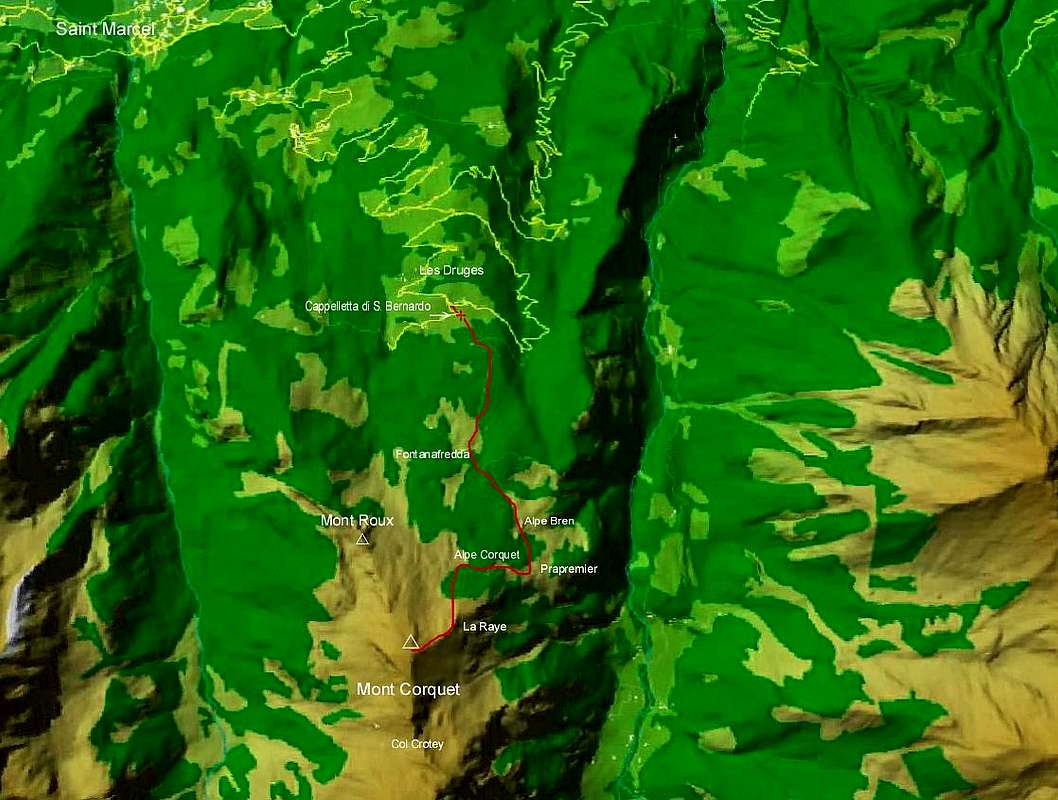
A) - From Les Druges (1.567m) through the North Slope and N-E Crest also called of "Raye", in terminal part: walk up by the path n° 14 behind a small fountain, near a splendid squared wooden rascard, toward a Chapel dedicated to San Bernardo getting the dirt road that trough Fontana Fredda (1.823m) and Alpe Bren (1.961m) Pastures leads to Prapremier (2.011m), the last one. Just behind the house, (stakes) leave on the left side the path to the Col de Crotey following toward W (path not always easy to find) toward the ruins of Alpe Corquet (2.124m). Herefrom turn toward S along the path that starts with two large hairpins, avoidind the remains of a landslide, and with many further hairpins go along the Northern slope that become steeper getting the NE ridge above "La Raye" (2.425m) near a small boosteer station. Climbeng easy rocks and passing to the left the last part in a short time you get the wide summit (sign; E; 0h'45; in all 2h'30/2h'45; rather varying in case of ski-mountaineering or snow rackets: in the first case to increase of around the half the time of route, while in the second to double it and also over ).
A) - Da Les Druges (1.567 m) per il Versante Nord e la Cresta NE detta della "Raye", nella parte terminale: indirizzarsi con il sentiero n° 14 dietro ad un caratteristico piccolo rascard squadrato ed in legno (fontana subito a lato), verso una Cappelletta dedicata a San Bernardo raggiungendo la poderale che, per gli Alpeggi di Fontana Fredda (1.823 m) e l'Alpe Bren (1.961 m), conduce all'ultima di Prapremier (2.011 m). Appena dietro la stessa (paline di segnalazione) lasciare a sinistra il bivio per il Col de Crotey dirigendosi invece a ovest (sentiero non sempre evidente) verso l'Alpe Corquet (2.124 m), oramai ridotta a rudere. Da questa su sentiero volgere decisamente a sud con due tornanti larghi; superare a sinistra i resti di una frana e, con tornanti più frequenti, risalire il facile versante Nord che aumenta di ripidità sbucando sulla cresta Nord-Est sopra "La Raye" (2.425 m), presso un piccolo ripetitore. Su roccette in breve si raggiunge, aggirando l'ultimo tratto a sinistra l'ampia vetta dove è posto un segnale (E; 0h'45; complessivamente 2h'30/2h'45; alquanto variabile in caso di sci-alpinismo o di racchette da neve: nel primo caso aumentare di circa la metà il tempo di percorrenza, mentre nel secondo raddoppiarlo ed anche oltre).
B) - From the Alpe Corquet Désot (= Of Under; 2.146m), the little Saddle 2.260m and the N-NW Ridge, in final part: to continue verse West-northwest through a small path not always evident that crosses lawns and bushes reaching the base of the small saddle 2.260m, sets among the Mont North Roux (2.277m; abandoned mines of copper) and the Mont Corquet in South, to which he arrives with a last slope as soon as steep (0h'30); from this, holding the last direction and medium a small path, it is climbed over first the quota 2.305m and after, with easy very panoramic run on the GROUP of the Great neighbor Roise in foreground, the following quota is reached 2.401m. Revolving to the right some rocky bands or to the left he continues on the superior meadow back reaching in little time the peak (E; 0h'45; altogether 2h'45/3h'00 with same remarks of A)-).
B) - Dall'Alpe Corquet Désot (= Di Sotto; 2.146 m), la Selletta 2.260 m e tramite la Cresta O-NO, nella parte finale: proseguire verso W-NW tramite un piccolo sentiero non sempre evidente che attraversa prati e cespugli raggiungendo la base della piccola sella 2.260 m, posta tra il Mont Roux a Settentrione (2.277 m; miniere abbandonate di rame) ed il Mont Corquet a Meridione, alla quale si arriva con un ultima salita appena più ripida (0h'30); da questa, tenendo l'ultima direzione e tramite un appena accennato sentiero, si scavalca prima la quota 2.305 m e poi, con facile percorso molto panoramico sul Gruppo della vicina e frontale Grande Roise, si raggiunge la successiva quota 2.401 m. Aggirando alcune fasce rocciose a destra o a sinistra si prosegue sul soprastante dosso prativo raggiungendo in poco tempo la vetta (E; 0h'45; complessivamente 2h'45/03h'00; stesse note di A)-).
C) - From the Alpe of Prapremier (= First Meadow; 2.010m; poster of signaling) through the Crotey Pass and South Crest: immediately in the last log cabin, where the path is undoubled, to leave on the right (Northwest) the ramification for the Alpe Corquet Désot (= Lower) to the preceding itineraries, continuing instead through the path n° 8 verse South-southwest and crossing two small rocky groins descending from the grat Crest NE (of the "Raye") of the Mont Corquet; immediately later to reach the alternative 2.149m where it is undoubled the small stream that goes down toward Chez Boche/Robbio little Villages in Clavalité Valley, inside Fénis Valley. Changing direction in South-southeast the path reaches the following alternative 2.186m, where continuous toward the Alpe Rossa Damon (= Red Higher Alp; 2.295m); to abandon him and gradually and with signaling n° 8A to turn first to West and then to Northwest reaching a bystander of it to quota 2.259m, again near the small stream; again varying and finally direction toward Southwest the same, left on the right (North) a deviation that with an a little marked small path it directs him toward the Alpe Corquet Damon (= Above Pasture; 2.429m) on the NE Crest (eventuality of connection with the itinerary A.), it reaches with easy and gradual slope diagonal the carving of the Crotey Pass (2.486m). From this last to decidedly climb toward North with a small path that overcomes a first rocky elevation (2.517m) on the right and it doubles the following quota 2.503m on the left, reaching the ample and wide grassland summital to around 320/30 meters from the Peak; to easily cross easily her without forced passage and with undulated run to conclude on Summit (E; 1h'15/1h'30; same notes and considerations).
C) - Dall'Alpe di Prapremier (= Primo Prato; 2.010 m; cartelli di segnalazione) per mezzo del Col Crotey e della Cresta Sud: subito dopo l'ultima baita, dove il sentiero si sdoppia, lasciare sulla destra (NO) la ramificazione per l'Alpe Corquet Désot verso i precedenti itinerari, continuando invece tramite il sentiero n° 8 verso S-SO ed attraversando due piccoli costoloni rocciosi provenienienti dalla Cresta NE del Mont Corquet (della "Raye"); subito dopo raggiungere il bivio 2.149 m, dove si sdoppia il piccolo torrente che scende verso Chez Boche/Robbio in Val Clavalité, all'interno della Val di Fénis. Cambiando direzione in S-SE il sentiero raggiunge il successivo bivio 2.186 m, dove continua verso l'Alpe Rossa Damon (2.295 m); abbandonarlo e gradualmente e con segnalazione n° 8A svoltare prima ad O e poi a NO raggiungendone un terzo a quota 2.259 m, nuovamente presso il piccolo torrente; variando nuovamente e finalmente direzione verso SO lo stesso, lasciata sulla destra (N) una deviazione che con un poco marcato piccolo sentiero si dirige verso l'Alpe Corquet Damon (= Di Sopra; 2.429 m) sulla Cresta NE (eventualità di collegamento con l'itinerario A), raggiunge con facile e graduale salita diagonale l'intaglio del Col de Crotey (2.486 m). Da questo ultimo salire decisamente verso N con un piccolo sentiero che supera una prima elevazione rocciosa (2.517 m) sulla destra e doppia la successiva quota 2.503 m sulla sinistra, raggiungendo l'ampia ed estesa prateria sommitale a circa 320/30 metri dalla Vetta; attraversarla facilmente senza passaggio obbligato e con percorso ondulatorio facilmente concludere (E; 1h'15/1h'30 con medesime considerazioni della Via A).
Difficulty
These itineraries are to be placed themselves: Route A. for BSA (= Good Skiers Mountain climber, according to cataloguing U.I.A.A.); from intra to take place themselves exclusively with good conditions of transformed snow, being already occurred accidents deadly cause avalanche; Itineraries B and C for Excursionists.
Questi itinerari sono da classificarsi: Itinerario A per BSA (= Buoni Sciatori Alpinisti, secondo catalogazione U.I.A.A.); da intrapprendersi esclusivamente con buone condizioni di neve trasformata, essendosi già verificati incidenti mortali causa valanga; Itinerari B e C per Escursionisti.
Equipment
Comprehensive Ski-mountaineering equipment of the ARVA (coadjutant tool the search in case of slavine or avalanches) for the Itinerary A.; Standard mountaineering equipment for Routes B and C.
Attrezzatura da Sci-Alpinismo comprensiva dell'ARVA (strumento coadiuvante la ricerca in caso di slavine o valanghe) per l'Itinerario A; Normale attrezzatura da Escursionismo per gli Itinerari B e C.
Campings
Remember that free camping is forbidden (except for emergency reasons, over 2.500m, from darkness until dawn).
Mountain Condition
You can get meteo information at the official site of the Regione Valle d'Aosta:
"Guida delle Alpi Occidentali" di Giovanni Bobba e Luigi Vaccarone C.A.I. Sezione di Torino Volume II (parte II), 25 Maggio 1896.
"Guida dei Monti d'Italia – Emilius Rosa dei Banchi-Parco del Mont Avic" di Giulio Berutto e Lino Fornelli - Club Alpino Italiano/Touring Club Italiano, Marzo 2005.
"Guida della Regione Autonoma Valle d'Aosta" di Mario Aldrovandi; Ed. S.P.E. di Carlo Fanton, Torino 1964.
"Diari Alpinistici" di Osvaldo Cardellina e Indice Generale accompagnato da Schedario Relazioni Ascensioni 1964-2019 (inediti).
MAPS:
Kompass "Gran Paradiso Valle d'Aosta Sentieri e Rifugi" Carta Turistica 1:50.000.
L'Escursionista "Tour de la Vallée de Cogne Grand Paradis" Carta dei sentieri 1:25.000.
Hapax "Les Sentiers" Comunità Montana Monte Emilius, Luglio 2000 1:25.000.
Enrico Editore Ivrea-Aosta "Gruppo del Gran Paradiso" 1:50.000.
L'Escursionista "Valle di Cogne" Carta dei Sentieri 1:25.000.
Parents refers to a larger category under which an object falls. For example, theAconcagua mountain page has the 'Aconcagua Group' and the 'Seven Summits' asparents and is a parent itself to many routes, photos, and Trip Reports.

 28938 Hits
 86.85% Score
 23 Votes